
The term “Artesian Well” is named for the former province of
Artois, France, where many such wells were drilled by Carthusian
monks since 1126. This technique was also known much earlier in
ancient Syria and Egypt. It is unknown whether the monks of Artois
learned of this technique from outside sources or developed it
independently on their own. This particular Artesian well,
according to local tradition, was found flowing from the trunk of a
Bay tree, hence the name of the town, Bay Springs.
Artesian wells sit atop recharging aquifers that can be very
large in size, spanning many miles across. Rainwater that is not
channeled as runoff (creeks, streams, rivers) slowly seeps through
porous materials and through cracks in otherwise impervious
material, moving downhill until its movement is blocked by a
completely impervious strata, where it pools and saturates the
surrounding porous strata. This happens underground in much the
same way as surface runoff flows downhill until its movement is
blocked and it pools to form ponds or lakes. This underground
pooling of water is what we sometimes refer to as the “water
table”.

Sometimes this underground water is not under pressure, and so
must be hauled up by bucket (think back to the “wishing wells” of
your childhood) or pumped up to the surface for use. In a
recharging aquifer such as this, the water table at the recharge
zone is at a higher elevation than the head of the well. Also,
saturated, porous strata such as limestone or sandstone may be
trapped between layers of impermeable rocks and clay and slowly
crushed. This constant pressure squeezes the water, so that when it
finds an escape hole (Artesian well) it defies gravity and flows up
out of the ground without pumping. This can be modeled by filling a
plastic baggie with water, placing a straw though the opening into
the water, and taping the opening closed around the straw. Squeeze
the baggie to force water up through the straw.
Artesian wells have been very important to man as he settled and
developed this country, as they offered a reliable source of clean
water for drinking and irrigation. The water is filtered after
traveling through many miles of porous sand and rock, in a process
that probably took many, many years to complete. This filtering
removes most of the pollutants that plague most surface runoff
waters today. The readily available clean drinking water not only
helps give birth to towns and cities, but also to entire
industries. Witness the wide variety of bottled spring water
available at your local grocery store. The water of this spring
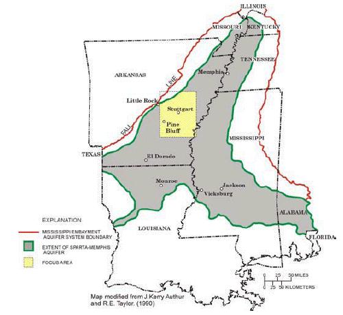
comes from the Sparta Sand Aquifer. It consists of varying amounts
of unconsolidated sand, inter-mixed with belts of silt and clay
within the Sparta Sand of the Claiborne Group. It extends from
south Texas, north into Louisiana, Arkansas, and Tennessee, and
eastward into Mississippi and Alabama. This strata is exposed on
the surface along the outside edges, and buried deeply beneath the
surface along its southern edge and central axis, which roughly
follows the Mississippi River.
To take credit and log this find, you must do the following: 1.
Take a photo of yourself with your GPSr, with the well in the
background. Post the photo with your log. 2. Estimate the flow of
the well in gallons per minute. Do this by filling a container of a
known size, recording the time it took to fill the container, then
calculating the flow in gallons per minute. E-mail the flow to me
via my contact link above.
Logs without the required information will be deleted. Please do
not post your answer to #2 with your log. I hope you learned
something about Artesian wells today, and enjoyed this
earthcache.
_
Congratulations to Rsarich and Camo Lady of FTF
Honors!