Narrow Hills Push Moraine EarthCache
Narrow Hills Push Moraine
Please note Use of geocaching.com services is subject to the terms and conditions
in our disclaimer.
Narrow Hills "Esker" Push Moraine
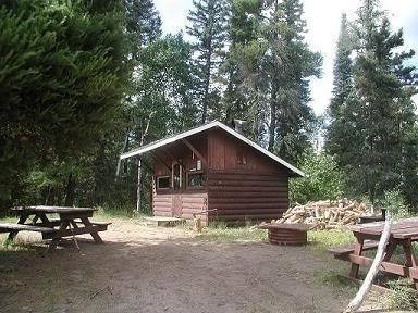
The posted coordinates will take you to the parking lot overlooking Grace Lakes. There are washrooms, a warmup shack, and a firepit with firewood at the posted coordinates.
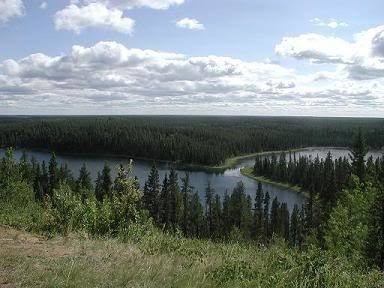
Esker Road begins at trailhead N54 01.835 W104 36.381 which leads east, then south along the top of the Push Moraine. As you drive the trail pay close attention to signage and lookout points along the trail as the information on the signs is required to answer the questions below. Some waypoints have been provided for your convenience. The altitude will slowly climb and when you reach the posted coordinates N53 58.544 W104 31.163, a great view of Grace Lakes to the south-west can be seen.
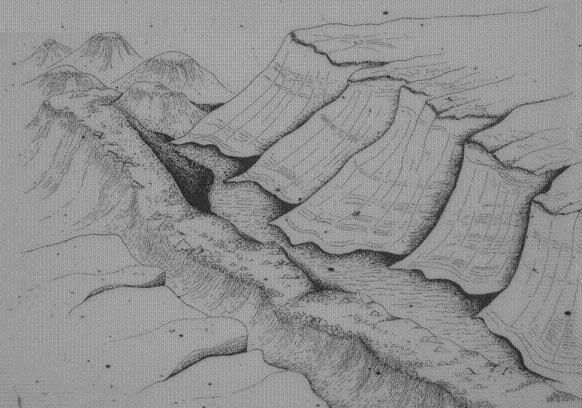
How the Push Moraine was Formed:
The "Narrow Hills Esker", as it was commonly called, was not a true esker. It was in fact a large Push Moraine. 10,000 years ago, a continental ice sheet was receding from this area, leaving behind it an outwash of sand and gravel. For a short period, the climate cooled and the ice reversed its flow, surging forward. The sand and gravel was caught up in its path and bulldozed into an array of hills and ridges called a push moraine.
The ridge that this road follows is particularly high and narrow because a massive ice block filled the basin where the Fishing Lakes lie today. It blocked the ice sheet’s advance, forcing the till straight up into a long, sinuous ridge.
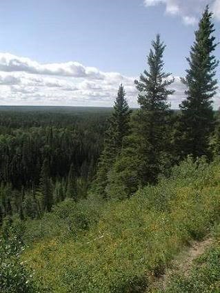
Vegetation at the Push Moraine:
To the East of this ridge is lowland that is home to a variety of trees including Black Spruce, Tamarack, and Willow. To the West of the ridge is mostly Jack Pine. Among some of the other vegetation that blanketed these hills were White Spruce, Balsam Poplar, and Trembling Aspen, along with an under covering of many varieties of wild fruits and shrubs. The ground cover is mosses typical of low growing plants.
On May 7th, 1977 a devastating fire caused by a lightning strike burned 66% of Narrow Hills Provincial Park forest. Since then the forest has regrown. A second fire in 1995 burned the Northern part of the park. Because of these two fires, the majority of the park’s forests have been burned within a 20 year timespan. A fire cycle of 50-150 years is typical of the boreal forest.
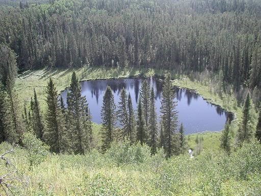
Kettle Lakes and Bogs:
This area also has many muskeg or bogs, along with several small lakes called "kettle holes," that were formed when huge blocks of ice had become buried then subsequently melted.
At N53.59.544 W104 32.032 is a lookout to the West. Look down at the water below to see an example of a bog. A bog is formed when drainage from a kettle lake is blocked causing a sedge mat to form at the water's edge. This sedge (peat) mat will eventually close over the entire lake.
The Ice Sheet Retreat – Glacial Lake Agassis
The Narrow Hills of Saskatchewan is part of the western shore line of Glacial Lake Agassiz. At the close of the age of glaciers, about 11,000 years ago, this pro-glacial lake stretched across the heart of North America, covering an area from the eastern part of the province eastward to almost the Great Lakes region of Ontario. Part of the lake reached down into the United States, near the Minnesota-North Dakota border. Lake Agassiz formed when the Laurentide Ice Sheet blocked the natural drainage to the Hudson Bay. Because it retained so much water, the lake became very large. It reached its greatest extent in about 7900 bc, when it was about 1,130 km (700 mi) long and covered 284,900 sq km (110,000 sq mi). Due to the blockage, Glacial Lake Agassiz drained slowly in a southerly direction, leaving behind traceable shorelines, such as the Narrow Hills of Saskatchewan, and a nearly flat valley. About 400 years later when the Ice Sheet had retreated enough to open up the channel to the Hudson Bay, Lake Agassiz rapidly drained.
Here's an 1895 Map of Glacial Lake Agassis:

Bibliographical information: Upham, Warren. "The Glacial Lake Agassiz". Plate III. Monographs of the en:United States Geological Survey: Volume XXV. Washington Government Printing Office: Washington, 1895. This image is in the public domain because it contains materials that originally came from the United States Geological Survey, an agency of the United States Department of Interior.
Esker Road Trail Points of Interest:
At approximately N54 01.064 W104 32.560 the elevation will greatly increase to about 1800ft. This is where the trail starts on the push moraine. Note that at higher elevations along the trail, the moraine is narrower. This is especially noticeable at N54 00.099 W104 32.507
In total the Narrow Hills run 24 kms in a northwest to southeast direction. At their maximum width, they are 1.6kms across.
According to signage along the trail, answer the following: (do not put the answer to this question in your log):
Question #1: How narrow is the narrowest part of the push moraine, how high does it rise above the surrounding landscape, and how long is the ridge?
Mackie Lake lookout exists at N53 58.843 W104 31.500. There is a trail to Mackie Lake for those who wish the hike.
The posted coordinates will take you to Grace Lakes lookout. There are outhouses, a warmup shack, and a fire pit with firewood for those who wish to have a weiner roast.
Grace Lakes are one of many lakes surrounding the Push Moraine that are kettle lakes, formed when a chunk of ice broke loose from the main glacier and became lodged in the ground, then subsequently melted to form the lake.
One feature of Kettle Lakes, such as Grace Lakes, is their great depth.
In the Early 1900’s the Esker Road trail was used by pioneers in the winter for hunting and fishing. Cabins were built, supplies were freighted in, and trails widened into roads. In 1940 a car trip from the south along this trail took 4 days.
From the signage located along the trail, answer these questions (do not put these answers in your log):
Question #2: How many species of mammals make the Narrow Hills of Saskatchewan their home?
Question #3: If you were to follow Esker trail further south, where would you end up and how much distance would you travel?
Narrow Hills Provincial Park Office:
N54 02.616 W104 36.747
Email the answers to the above 3 questions to Northbound through my profile (karen.larsson@hotmail.com).
Do not post the answers in your log.
Don’t forget to post a picture of yourself holding your GPS with Grace Lakes in the background.
Bonus question (not required to log as a find): While at the Park Office obtaining your day pass ($7.00), ask for a copy of Grace Lakes depth map (Aug 6th, 1959). What is the maximum depth of Grace Lakes in feet and approximately how far from the shoreline is the maximum depth?
The main trail can be further traveled by foot or bicycle in summer or a Snowmobile in winter. Note that all terrain vehicles are not allowed anywhere on Esker road.

Links:
Visit Ontario's Lakehead University ongoing Ancient Lake Agassiz Project at a Glacial Lake Agassiz Project
More information about Ancient Lake Agassiz can be found at this website: Minnesota Dept. of Natural Resources
A technical document about Ancient Lake Agassiz can be found at Ancient Lake Agassiz
Additional Hints
(No hints available.)
Treasures
You'll collect a digital Treasure from one of these collections when you find and log this geocache:

Loading Treasures