
 Beach access is only available along a short but steep stairway. Parking is available along the road, but it is typically busy. The beach is also narrow, so use good judgment when there is high surf.
The Folds
The rocks that make up the coastal cliffs at this location are part of the Monterey Formation. The Monterey Formation is common along the coast of California. In fact, similar rocks were deposited throughout the Pacific Rim during the Miocene. When these rocks were initially deposited 17.5 to 6 million years ago, they were laying flat like pages of a book. Now however, you see the layers of rock have been tilted and folded.
Folds form when layered rock is squeezed under just the right conditions that the rock bends instead of breaking (a fault). The process can be seen by taking a stack of papers and pushing the ends together. The stack bends into folds. The layers of rock actually help form folds because each layer of rock can slide across the top of the layer below it easier than one large massive block of rock.
The folds are given names depending upon how the layers bend. The graphic below shows a series of flat lying rocks. The oldest rocks (the light yellow) are at the bottom and the youngest rocks (the dark red) are on the top. When the layers of rock appear to bend away from each other forming a peak, this is called an anticline. In this case the oldest rocks are in the center of the fold. When the layers of rock appear to bend toward each other forming a trough, this is called a syncline. In a syncline the youngest rocks are in the center of the fold. There are other types of folds, but they are basically complex variations of these two types of folds. 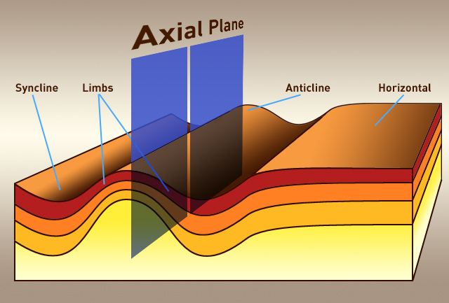
Diagram source: fox-and-the-hound
Folds can occur at many different scales. The folds at the given coordinates are small enough to see in one outcrop. With larger folds, you only see a portion of the fold at time. As part of the logging requirements you will attempt to identify the type of fold formed by the rocks to the east of this point. This same process, examining portions of a fold to describe the whole fold structure, is used to identify folds that are sometimes miles wide.
The Unconformity
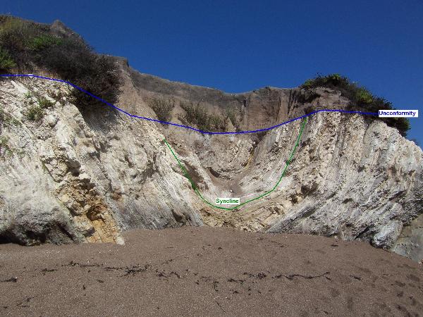 When rocks of two different ages are touching, the surface where they touch is called an unconformity. An unconformity represents missing time in the rock record. This could be because no rocks were deposited during that time or the rock was eroded away and new rock deposited on it. Unconformities are classified by how the rocks on either side of the unconformity are related.
At this beach the unconformity is located at the contact between two sedimentary rocks, the relatively thinly layered Monterey Formation on the bottom and the rounded cobbles, sand, and soil on the top. The rock layers of the Monterey Formation are folded and often form an angle with the unconformity. The rock layer above the unconformity is parallel with the unconformity. This type of unconformity is called an angular unconformity.
Logging requirements:
Send me a note with :
- The text "GC1G4TE Unconformity and Folding at Pismo Beach" on the first line
- The number of people in your group.
- What kind of fold is observed between points A(N35 09.337 W120 40.645), B(N35 09.332 W120 40.640), and C(N35 09.299 W120 40.624) You can assume that the lowest layers are the oldest (I think that is a good assumption in this area)
- At each of the secondary coordinates, evaluate if the type of unconformity remains the same.
- Based on how the layers below the unconformity are cut off, hypothesize whether the missing time is due to no rock being deposited or from erosion.
The above information was compiled from the following sources:
- Behl, Richard J. (California State University, Long Beach), THE MONTEREY FORMATION OF COASTAL ORANGE COUNTY, CALIFORNIA: PRELIMINARY SEDIMENTOLOGIC AND DIAGENETIC FINDINGS
- Dr. Judson L. Ahern http://geophysics.ou.edu/dynamic/notes/structure/structure.html