Plus haut, des moraines latérales ont conflué afin de former des moraines médianes.
- Invisible sous la glace se trouve la moraine de fond, arrachée du fond de la vallée et broyée par le mouvement de la glace.
- À l'extrémité en aval, ces restes des rochers tombent de la glace comme une moraine frontale.
- Parfois, le front de la glace avancera de nouveau; en poussant les débris devant, à la manière d'un bulldozer. En ce cas, une moraine poussée sera trouvée.
- Lors de la retraite du front d'un glacier, d'une calotte glaciaire ou d'une nappe de glace, la retraite s'arrête de temps en temps, ce qui provoque la formation d'une série de moraines de récession.
La moraine est un empilement de gravats et de cailloux véhiculés par un glacier et qui se retrouve à ses abords. La moraine veut dire aussi le produit de l'érosion glaciaire, matériaux résultant du travail du glacier.
Le mot moraine porte un double sens donc, car les origines de la moraine sont de deux sortes :
- allogène : tout ce que le glacier reçoit en sa surface (éboulis dus à la cryoclastie par exemple). Cette moraine protège le glacier du rayonnement du soleil (cf. la mer de glace)
- autochtone : matériaux produits par le travail même du glacier (broyage de son lit).
Source Wikipedia
Pour enregistrer cette earthcache comme trouvée:
Faire parvenir vos réponses par courriel au propritaire de la cache.
1- De quel type de moraine s’agit-il ?
2- Au point zero quel altitude indique votre GPS ?
De plus, vous devez inclure dans votre log
3-Une photo de vous avec votre GPSdevant le champ de guérêts.
Toutes inscriptions sans les conditions requises seront supprimées
Rigaud is a municipality in southwestern Quebec, Canada in the county of Vaudreuil-Soulanges at the junction of the Ottawa River (Riviere des Ouatouais) and the Rigaud River. It is the farthest western suburb of Montreal.
Its main attraction is Mont-Rigaud, a small mountain with downhill ski runs, a private school (Collège Bourget), a monastery, and a shrine dedicated to the Virgin Mary (Sanctuaire Notre-Dame-de-Lourdes). The mountain is also home to an unusual, natural rock garden known as the "champs de patates", so named because of the local legend that it was once a potato field, turned to stone by God because the farmer worked on Sunday. In the reality it is a Moraine
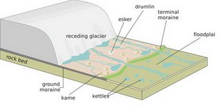
Moraine refers to any glacially formed accumulation of unconsolidated glacial debris (soil and rock) which can occur in currently glaciated and formerly glaciated regions, such as those areas acted upon by a past ice age. This debris may have been plucked off the valley floor as a glacier advanced or fallen off the valley walls as a result of frost wedging. Moraines may be composed of silt like glacial flour to large boulders. The debris is typically sub-angular to rounded. Moraines may be on the glacier’s surface or deposited as piles or sheets of debris where the glacier has melted. Moraines may also occur when glacier or iceberg transported rocks fall into the sea as the ice melts.
Lateral moraines
Lateral moraines are parallel ridges of debris deposited along the sides of a glacier. The unconsolidated debris is deposited on top of the glacier by frost shattering of the valley walls and from tributary streams flowing into the valley. The till is carried along the glacial margin until the glacier melts. Because lateral moraines are deposited on top of the glacier, they do not experience the postglacial erosion of the valley floor and therefore, as the glacier melts, lateral moraines are usually preserved as high ridges.
Moraines clearly seen on a side glacier of the Gorner Glacier, Zermatt, Switzerland. The lateral moraine is the high snow-free bank of debris in the top left hand quarter of the picture. The medial moraine is the double line of debris running down the centre-line of the glacier.
Lateral moraines stand high because they protect the ice under them from the elements, which causes it to melt or sublime less than the uncovered parts of the glacier. Multiple lateral moraines may develop as the glacier advances and retreats.
Ground moraines
Ground moraine makes an irregular, rolling topography
Ground moraines are till covered areas with irregular topography and no ridges often forming gently rolling hills or plains. It is accumulated under the ice by lodgement, but may also be deposited as the glacier retreats. The ground moraine is located between the two lateral moraines.
End or terminal moraines
End moraines or terminal moraines are ridges of unconsolidated debris deposited at the snout or end of the glacier. They usually reflect the shape of the glacier's terminus. Glaciers act much like a conveyor belt carrying debris from the top of the glacier to the bottom where it deposits it in end moraines. End moraine size and shape is determined by whether the glacier is advancing, receding or at equilibrium. The longer the terminus of the glacier stays in one place the more accumulation there will be. There are two types of end moraines, terminal and recession moraines. Terminal moraines mark the maximum advance of the glacier. Recessional moraines are small ridges left as a glacier pauses during its retreat. After a glacier retreats the end moraine may be destroyed by postglacial erosion.
Recessional moraine
A recessional moraine is in the form of a series of ridges running across a valley behind terminal moraine. They form during standstills in a glaciers retreat.
Medial moraine
A medial moraine is a ridge of moraine that runs down the centre of a valley floor. It is formed when two glacers meet and the debris on the edges of the adjacent valley sides join and are carried on top of the enlarged glacier. As the glacier melts or retreats, the debris is deposited a ridge down the middle of the valley floor. The Kaskawash glacier in the USA has a ridge of medial moraine 1km wide.
Ref. Wikipedia
To register your visit on this EarthCache:
Send by email your answers to the owner of this cache
1- About what type of moraine is it?
2- At ground zero, what is the altitude shown on your GPS ?
3- In addition, you must post in your log
a picture of you with your GPS
in front of the rock garden
All inscriptions without required conditions will be deleted