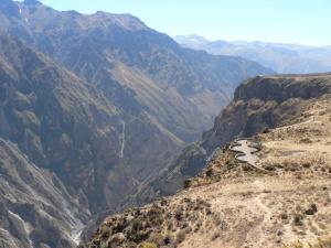
For many years Colca was mentioned as the deepest canyon on the
world. Now it is known that it is the second deepest. The Colca
canyon is easily recognizable in even low-resolution satellite
photos of the region. The Colca Valley is a colorful Andean valley
with towns founded in Spanish Colonial times and formerly inhabited
by the Collaguas and the Cabanas. The local people still maintain
ancestral traditions and continue to cultivate the pre-Inca stepped
terraces.
CANYONS
A canyon (rarely cañon) or gorge is a deep valley between
cliffs often carved from the landscape by a river. Most canyons
were formed by a process of long-time erosion from a plateau level
(in geology and earth science, a plateau, also called a high
plateau or tableland, is an area of highland, usually consisting of
relatively flat rural area). The cliffs form because harder rock
strata that are resistant to erosion and weathering remain exposed
on the valley walls. Canyons are much more common in arid areas
than in wetter areas because weathering has a lesser effect in arid
zones. Canyon walls are often formed of resistant sandstones or
granite. Submarine canyons are those which form underwater,
generally at the mouths of rivers. The word canyon is Spanish in
origin (cañón). The word canyon is generally used in
the United States, while the word gorge is more common in Europe
and Oceania, though it is also used in some parts of the United
States and Canada. The rare word defile is occasionally used in
England.
A famous example is the Grand Canyon in Arizona. In the
southwestern United States, canyons are important archeologically
because of the many cliff-dwellings built there, largely by the
earlier inhabitants, Ancient Pueblo Peoples.
Sometimes large rivers run through canyons as the result of gradual
geologic uplift. These are called entrenched rivers, because they
are unable to easily alter their course. The Colorado River and the
Snake River in the northwestern United States are two examples of
tectonic uplift. A tectonic uplift is a geological process most
often caused by plate tectonics which increases elevation. The
opposite of uplift is subsidence, which results in a decrease in
elevation. Uplift may be orogenic or isostatic.
Canyons often form in areas of limestone rock. Limestone is to a
certain extent soluble, so cave systems form in the rock. When
these collapse a canyon is left, for example in the Mendip Hills in
Somerset and Yorkshire Dales in Yorkshire, England.
GEOGRAPHY
The Colca River starts high in the Andes at Condorama Crucero Alto
and changes its name to Majes, and then to Camana before reaching
the Pacific Ocean. Parts of the canyon are habitable, and Inca and
pre-Inca terraces are still cultivated along the less precipitous
canyon walls. The small town of Chivay is on the upper Colca River,
where the canyon is not so deep but where many terraces are located
in the canyon and continue for many kilometers downstream. As the
canyon deepens downriver, a series of small villages is spreaded
out over the approximately 35 miles (56 km) between Chivay and the
village of Cabanaconde. The canyon reaches its greatest depth and,
in contrast, after 15 miles (24 km) to the southeast rises the
20,630-ft (6,288-m) Nevado Ampato, a snow-capped extinct
volcano.
ATTRACTIONS

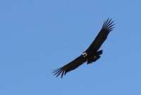
The canyon is a home of the Andean Condor (Vultur gryphus), a
world-wide protected species. The condors can be seen at fairly
close range while they fly through the canyon walls and they are an
increasingly popular attraction. 'Cruz del Condor' is a popular
tourist stop to view the condors, the pass where condors soar
gracefully on the rising thermals occurring as the air warms. The
best time to watch condors is early morning and late afternoon when
they are hunting. At this point the canyon floor is 3,960 ft (1,200
m) below the rim of the canyon.
NAME
The name Colca refers to small holes in the cliffs in the valley
and canyon. These holes were used in Inca and pre-Inca times to
store food, such as potatoes and other Andean crops. They were also
used as tombs for important people.
HISTORY
The Spanish laid out towns along the canyon and built churches
there, but the towns did not thrive and have faded out of memory.
In the 1980s, the Majes Hydroelectric Project built roads there and
opened the area to outsiders. Today's access is usually through
Arequipa city.
Source: Wikipedia and NationMaster.com
CACHE
 The above coordinates will take you to an overlook Cruz del
Condor. To log the cache you have to:
1) Take a picture which shows both the view at the overlook and you
with your GPS
2) Answer following three easy questions:
a) How deep is Colca Canyon in the deepest point?
b) What is the approximate length of Colca Canyon?
c) What is the name of the deepest canyon on the world?
Post your picture with your log and email me your answers via my
profile page. Incomplete answers or cheats will be deleted from
log.