RUHRSANDSTEIN
Am Kassenberg in Mülheim a. d. Ruhr im Stadtteil Broich wird in einem Steinbruch Sandstein aus der Karbonzeit gewonnen. Durch das Vorkommen entlang der Ruhr wird dieser Sandstein „Ruhrsandstein“ genannt. Bei diesem Cache spaziert Ihr auf dem Fossilienweg entlang. Er ist ein geologischer Lehrpfad auf dem Ihr die Möglichkeit habt verschiedene Ausprägungen des Ruhrsandsteins zu betrachten.
Entstanden ist Ruhrsandstein aus Fluss-Sedimenten vor etwa 290 Millionen Jahren im Oberkarbon im so genannten Namur C. Übertretende Ströme und damit Überschwemmungen spülten Sand und Schlamm an die Ufer. Nach jeder Überschwemmungen blieben mehrere Meter hohe Sand- und Tonablagerungen liegen. Durch die Absenkung des Untergrunds und darüber neu liegen gebliebene Schichten und der damit verbundenen Last wurde der Sand verdichtet und es entstand Sandstein.
Sandstein setzt sich Hauptsächlich aus Quarz, Alkalifeldspat und Plagioklas zusammen. Es gibt noch viele Nebengemenge wie z.B. Tonmineralien, Pyrit und Karbonate uvm.
Ruhrsandstein ist hauptsächlich mittelgrau mit wechselnden gelbraunen Anteilen. Durch Oxidation der Eisenkarbonate treten gelbbraune Verfärbungen auf. Gelegentlich findet man in Ruhrsandstein Versteinerungen von Pflanzen (z.B. Farne). Ruhrsandstein wird in sechs Steinbrüchen gewonnen. Hier in Mülheim-Broich ist der westlichste Steinbruch. Weitere Steinbrüche befinden sich in Dortmund, Herdecke, Sprockhövel und Wetter. Verwendet wird Ruhrsandstein bei Boden- Fassadenplatten, Stufen, Pflastersteinen und für Böschungsteine. Auch Steinmetze verwenden Ruhrsandstein bei ihren Arbeiten.
AUFGABEN UND LOGBEDINGUNGEN:
Parken könnt Ihr bei N 51° 24.954 und E 006° 52.032. Dort ist auch der Zugang zum Fossilienweg. Lauft diesen gerade durch bis zum Ende. Die Gesamtstrecke mit Hin- und Rückweg beträgt 2,5 km. Entlang des Weges sind viele Bänke und Spielmöglichkeiten für Kinder. Am Ende des Weges ist ein Spielplatz. Unterwegs findet Ihr die Lösung für drei Fragen die beantwortet werden müssen und zwei Objekte bei denen Ihr je ein Bild machen müsst um am Ende diesen Cache Loggen zu dürfen.
(Es wird ein Zollstock oder Messband benötigt!)
1. Aufgabe (Frage): Direkt beim Eingang zum Fossilienweg neben dem Eingang zum „Steinbruch Rauen“ befindet sich ein hoher spitz zulaufender Ruhrsandstein. Bitte messt die Höhe des Steines und teil diesen uns mit.
2. Aufgabe (Bild): Es führt eine steinerne Brücke über den Weg. Kurz vor dieser Brücke findet Ihr folgendes Motiv:
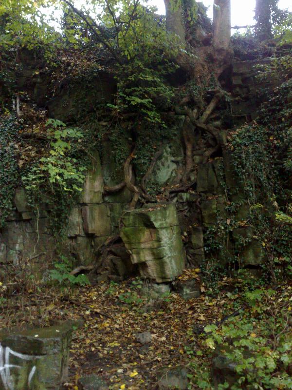
Hier möchte ich ein Foto mit dieser Formation und Euch davor/daneben.
3. Aufgabe (Frage): Unter der steinernen Brücke sind mehrere Steine. Auf einem der Steine ist ein Buchstabe in weißer Farbe zu finden. Welcher Buchstabe ist es?
4. Aufgabe (Bild): Am Ende des Weges findet ihr folgendes Motiv:
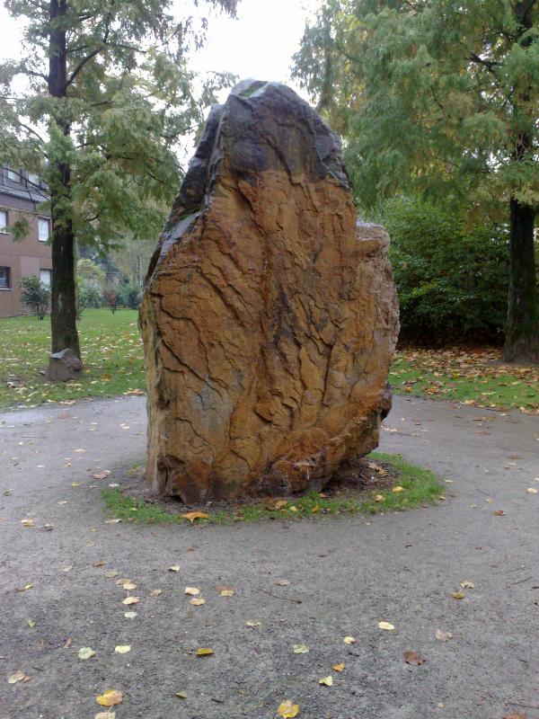
Auch hier bitte ein Bild mit Euch davor/daneben. Da ich zwei Bilder von Euch möchte, dürft ihr bei diesem ruhig ausgefallener/kreativer vorgehen...müsst aber nicht.
5. Aufgabe (Frage): Nach dem zweiten Bild seid Ihr auch am Ende des Fossielienwegs. Wie viele Minuten bräuchtet Ihr von hier bis zum Ruhruferweg und zum Kloster Saarn?
Bitte beim Loggen die beiden Bilder hoch laden und die Antworten auf die drei Fragen an mich mailen! Earthcache_Ruhrsandstein_am_Kassenberg@gmx.de. Im Betreff bitte Ruhrsandstein + Euren Cacher-Namen mit dem Ihr auch Euren Log durchführt erwähnen. Bitte die Antworten auf die Fragen nicht im Log erwähnen! Logs bei den ich nicht die Antwort auf die drei Fragen erhalten habe und/oder nicht die beiden Bilder finden kann werden gelöscht.
Ich wünsche euch viel Spaß bei diesem Cache!
Anreise mit ÖPNV:
Die Anreise mit ÖPNV ist auch möglich. Ihr müsst zur Haltestelle „Schloss Broich“. Hier halten die Linien 132, 133 und 752. Der Zugang zum Cache ist dann bei N 51° 25.510 and E 006° 52.390. Von oberhalb der Treppe seht Ihr direkt das Motiv von Aufgabe 4. Dabei lauft ihr den Weg in umgekehrter Reihenfolge ab. Also von Aufgabe 5 zu 1.
In English
Ruhr-Sandstone
At the Kassenberg in Mülheim a. d. Ruhr in the district of Broich, Sandstone from the Carbon-Age is extracted.Because of it's appearance along the River Ruhr this Sandstone is called Ruhr-Sandstone.
By this Cache you will walk upon the Fossil-way. This is a geological, natural trail on which you will have the possibility to examine different characteristics of the Ruhr-Sandstone.
Ruhr-Sandstone arose 290 million years ago in the carboniferous in the so called Namur C. Pass over streams and flooding washed sand and mud to the banks of the River Ruhr.
After every flooding sand and clay sedimented several feet high. Through the lowering of the underground and the new layers of sand and clay after every flooding, and the enormous weight, the sand became compressed and sandstone was the result.
Sandstone consists in general of quartz, alkali feldspar, and plagioklas and there are a lot of additional materials like clay minerals, pyrites and carbones.
Ruhr-Sandstone has normally a mid-grey colour with changing yellow-brown dues.Through the oxidation of the iron-carbonates yellow-brown colour changes occur.
Occasionally fossils like petrification of plants (e. g. fern), can be found in the Ruhr-Sandstone.Ruhr-Sandstone is extracted in six different stone-pits. The one in Mülheim-Broich is the most western stone-pit of all of them.
Further stone-pits can be found in the cities of Dortmund, Herdecke, Sprockhövel and Wetter.Ruhr-Sandstone is used to manufacture paving tiles, facing tiles, steps, flagstones and so on. Also stone-cutters use Ruhr-Sandstone for their works.
You can park your car by N 51° 24.954 and E 006° 52.032.
There is also the entrance to the Fossil-way.
Walk all the way straight to the end. The complete distance for the way forth and back is about 2.5 km long. Along the way you will find a lot of benches and possibilities for children to play. At the end of the way is a playground. Along the way you will find the answers for the 3 questions you have to answer and also 2 objects of which you have to take a photo in order to be permitted to log this cache.
Tasks to fulfill are the 2 photos and the 3 questions to be answered:
(You will need a folding rule or a measuring tape).
1. Task (question): directly at the entrance to the fossil-way besides the entrance to the stone-pit: there is a high and pointy piece of Ruhr-Sandstone. Please measure the height of the rough stone and tell us the answer.
2. Task (Photograph): A stone bridge leads over the way. Shortly before this bridge you will find the following motive:
Here I want a photo from you in front or besides of this formation.
3. Task (question): Beneath the stone bridge are several stones. On one of the stones you will find a letter in white colour. Which letter is it?
4. Task (photo): At the end of the way you will find the following motive:
again please take a photo, showing you in front or besides. As I will get 2 photos from you, you can be more creative or fancy or unusual if you want. (Of course not a must).
5. Task (question): After you have taken the second picture you will find yourselves at the end of the fossil-way. How many minutes would take a walk to the Ruhruferweg and to the Cloister of Saarn?
In order to log this cache, please upload the two pictures and send us the answers to the 3 questions via e-mail: Earthcache_Ruhrsandstein_am_Kassenberg@gmx.de. Please add "Ruhr-Sandstone and you Cacher's name in the reference line of this e-mail. Please do not post the answers to the questions into the log. Logs without the correct answers or photos will be deleted.
We wish you a lot of fun with this Earth-Cache!
Journey without car (e. g. by bus or tram) is also possible:
The Bus stop is called "Schloss Broich" You will find entrance to the cache at: N 51° 25.510 and E 006° 52.390.From atop the stairway you can see the motive of task 4 and 5. In this case you follow the way in changed direction – which also means from task 5 to 1.