The Big Spring EarthCache
-
Difficulty:
-

-
Terrain:
-

Size:  (not chosen)
Please note Use of geocaching.com services is subject to the terms and conditions
in our disclaimer.
Go south on Highway 70 approximately 1 mile from US 11W
Rogersville, TN.. Turn left onto Big Springs Road. You are
there!
Springs are a part of the larger Cycle of Water. The
atmosphere, the sun, mountains, rivers, oceans, the underground and
yes, springs, large and small are all part of the cycle of
water.
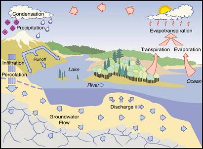
The Cycle of
Water
Springs have always been crucial to the survival of mankind
and the Big Spring is no different with
it’s contributions to survival. The Big
Spring is much older than the city of Rogersville. It has
extinguished the thirst of Indians, frontiersmen and some of the
early settlers of the area. You will note the now unused
springhouse. While it is several decades old, no one seems to know
it’s builder or it’s age. While the Spring has slowed during
periods of drought, it has never been known to totally stop. While
the spring is crystal clear, we cannot vouch for it’s purity
therefore we do not necessarily recommend drinking.

The Big Spring
The Big Spring flows out of the
hillside just below the Henards Chapel Baptist Church and gently
empties into the Holston River in less than one mile.
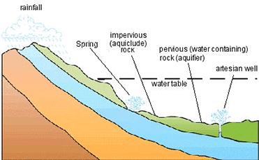
The Flow of Underground
Water
The limestone is one of the ingredients for the formation
of the karst topography of Hawkins County. The
Big Spring and other springs are water
resources formed when the side of a hill, a valley bottom or other
excavation intersects a flowing body of ground water at or below
the local water table, below which the subsurface material is
saturated with water. Water issuing from an artesian spring rises
to a higher elevation than the top of the confined aquifer from
which it issues. A spring is the result of an aquifer being filled
to the point that the water overflows onto the land surface. They
range in size from intermittent seeps, which flow only after much
rain, to huge pools flowing hundreds of millions of gallons daily.
Springs are not limited to the Earth's surface, though. Recently,
scientists have discovered hot springs at depths of up to 2.5
kilometers in the oceans, generally along mid-ocean rifts
(spreading ridges). The hot water (over 300 degrees Celsius) coming
from these springs is also rich in minerals and sulfur, which
results in a unique ecosystem where unusual and exotic sea life
seems to thrive.
The amount of water that flows from springs depends on many
factors, including the size of the crevices or caverns within the
rocks, the water pressure in the aquifer, the size of the spring
basin, and the amount of rainfall. If the groundwater is under
sufficient pressure, the spring (or a well) might shoot water into
the air-artesian well or spring. Human activities also can
influence the volume of water that discharges from a
spring—groundwater withdrawals in an area can reduce the amount of
water and the pressure in an aquifer, causing water levels in the
aquifer system to drop and ultimately decreasing the flow from the
spring. The Big Spring’s flow varies with
the seasons but seldom if ever has it run dry!
NOTE: Bring a
thermometer with you to the Spring. You will need it to claim the
find!
In order for you to claim a find of the Spring you must
accomplish the following: 1. Post a picture of yourself
and your party with GPSr in hand and the Spring in the background,
2. Email the following: (A) what is the temperature
of the Spring, (B) the flow of the Spring is from (choose
one): a. under a bridge. b. from under the road or c. from under
the spring house, (C) what is direction (in degrees) of the
flow of the Spring from the Spring house to the other side of the
road? Use your GPSr to take a heading. Please do not post your
answers and answer by email only.
We sincerely hope you enjoy the Big
Spring and be sure to find DMflyer's (GCRAQC) very
nearby cache!
This Earthcache was approved by the
Geological Society of America
| We have earned GSA's highest
level: |
 |
Additional Hints
(Decrypt)
Fcevat vagb npgvba naq svaq zr!
Treasures
You'll collect a digital Treasure from one of these collections when you find and log this geocache:

Loading Treasures