North Jersey Checkpoint
Challenge
Checkpoint
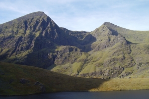
Carrauntoohil
Welcome to the northern section of
Pyramid
Mountain Natural Historic Area in Kinnelon, NJ. This cache will
fulfill the “Carrauntoohil”
requirement for the
North Jersey Checkpoint Challenge.
Carrauntoohil – (from the Irish: Corrán Tuathail
meaning "Tuathal's sickle") is the highest peak in Ireland. Located
in County Kerry, it is 1,038m (3,406ft) tall and is the central
peak of the Macgillycuddy's Reeks range. The Reeks contain most of
Ireland's highest mountains and lie at the eastern end of the
Iveragh Peninsula. Iveragh is the largest of five adjoining
peninsulas which spread like fingers into the Atlantic Ocean along
the south west coast of Ireland. This picturesque peninsula is
separated from its neighbours by the waters of
Dingle Bay to the north and
Kenmare Bay to the south. Iveragh is famous for
the Ring of
Kerry drive - a route which circumnavigates Iveragh by
the coast and enjoys marvellous views.

Every year since 1987 the IMRA (Irish Mountain
Racing Assoc.) has organized a running race up and down the
mountain, which draws an impressive field from around the world.
The race route is 12.4 kilometers round trip and the ascent/descent
totals 1,192m. Local farmer John
Lenihan from Glounageenty won the race for 11 years
straight with a best time of 71min, 43sec in 1988.
The mountain is most often climbed from the north-east, along the
Hag's Glen and up the steep Devil's Ladder to the col between
Carrauntoohil and Cnoc na Péiste, and then north-west to the
summit. The route has become more dangerous in recent years due to
loose stones and crowding. No special equipment is needed to climb
the mountain, but caution is advised. The weather conditions on the
mountain are very changeable, and there have been a number of
deaths due to many inappropriately dressed tourists attempting the
peak each summer.
This cache is a nice 0.6 mile stroll from the posted parking
location along the green trail, which brings you to about 140ft
from the cache. The trailhead is behind and to the right of the
tennis courts. There are some minor elevation changes along the
hike. Cache is an ammo box hidden in the base of a falling
tree overlooking the Taylortown Reservoir. Please rehide so as not
to be visible to casual passers by.
Official NJCC
Information
The Northern New Jersey Cachers (NNJC) are sponsoring the North
Jersey Checkpoint Challenge series. This challenge is intended to
take geocachers on a tour of Northern New Jersey (loosely defined
as north of I-78) while finding caches placed by members of the
NNJC. On the tour, we hope you will find North Jersey an
interesting and beautiful part of our great state.
Scattered around the area are 26 checkpoint caches and a final
challenge cache -
North Jersey Checkpoint Challenge (GC1NNJC). The names of the
individual checkpoint caches are based on a phonetic alphabet using
mountain names since North Jersey is the mountainous region of the
state. The 26 checkpoints do not have to be completed in any
particular order. See the NJCheckpoint bookmark for the complete
list of caches.
Hidden within the 26 checkpoint caches are numbers to be used in
determining the coordinates of the final North Jersey Checkpoint
Challenge cache – please be sure to note them while you are
there.
While there are no special logging requirements for the 26
checkpoint caches, there are special logging requirements for the
final challenge cache. Complete information can be found on the
North Jersey Checkpoint Challenge (GC1NNJC) cache page.
Happy caching and enjoy the North Jersey Checkpoint
Challenge!!!
This cache is certified North
Jersey

Free Hit Counter