Det fredede areal Nordby Bakker blev dannet under den seneste istid ( for 15 – 100.000 år siden).
Indlandsisen kom glidende som en stor gletcher fra Norge, Sverige og Østersøområdet og skubbede store volde af sten, ler og sand foran sig.
Isen skød flere gange hen over øen. Spor af mindst 3 isfremstød kan ses i klinterne langs kysten.
Stenene som isen bragte med, de såkaldte ledeblokke (f.eks de magmatiske bjergarter rombeporfyr og rektangelporfyr fra Oslo-området), kan findes på Samsøs nordvestkyst ved Issehoved.
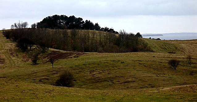
Nordøens karakteristiske morænelandskab, der består af smukt afrundede bakker gennemskåret af dybe smeltevandsdale, blev dannet ved isens langsomme bevægelser gennem mange år.
Når der var kolde perioder, bevægede isen sig fremad og når klimaet efterfølgende blev varmere, skete der en afsmeltning og tilbagetrækning.
Disse bevægelser efterlod det medførte materiale som en gold vold foran isranden, en såkaldt rand- eller endemoræne.
Ved isens endelige afsmeltning blev den dannede randmoræne foran iskanten gennemskåret af store mængder smeltevand og det brudte bakkelandet opstod.
Møgelskår er en sådan smeltevandsdal og Ballebjerg er med sine ca. 64 m Samsøs højeste bakke.
Jorden i bakkerne er gruset og ikke særlig frugtbar og områdets bønder anvendte den derfor før i tiden til fælles græsningsareal.
Nutidens landskabspleje varetages den dag i dag af græssende kreaturer.
Der er offentlig adgang til statens områder. Informationstavler er opsat flere steder i området.
Download folderen Nordby Bakker Samsø fra www.sns.dk
______________________________________________________________________
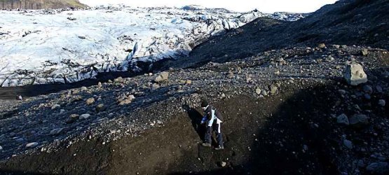
Morænebakkedannelse, som det kan opleves på Island
_______________________________________________________
Log vejledning:
Earthcacher er en speciel type geocacher, hvis formål er at lære dig noget om jordklodens geologi. Du vil ikke finde en fysisk cache på cachekoordinaten, og du skal derfor bevise dit besøg på stedet samt din nye viden ved at overholde følgende retningslinjer:
Før du logger: send en mail til (oakees@gmail.com) med svaret på de nedenstående spørgsmål samt det billede (optional logging task) , der bliver beskrevet herunder.
Du er velkommen til at logge cachen samtidig med at du sender dine svar til os. Kan svarene ikke godkendes, kontakter vi dig.
OBS: Husk: Skriv ikke svarene i loggen!
Spørgsmål 1: Hvor mange gange var Samsø dækket af istidens gletchere?
Spørgsmål 2: Hvilke sten havde isen med fra Norge?
Spørgsmål 3: Beskriv med egne ord, hvordan bakkerne blev dannet.
Billedet:
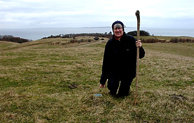
(Optional logging task) Tag et billede af dig selv og din GPS på koordinaten = Fikspunktet (Fredet punkt)
Du skal vende ryggen mod nord, så man kan se P-pladsens bord/bænkesæt i baggrunden. Dette foto gælder som bevis på din fysiske tilstedeværelse på cachekoordinaten.
Se billedeksempel under den engelske tekst.
God fornøjelse.
================================================================
*** The protected areaNordby Bakker– an area of outstanding natural beauty – was formed during the latest iceage in Denmark (15 – 100.000 years ago)
The icecap came gliding as a gigantic glacier from Norway, Sweden and the Baltic Area and pushed huge banks of stones, clay and sand in front of it.
The ice was gliding across the island several times. You can find at least 3 different marks of glacial deposits in the cliffs along the northcoast.
Some of the most common stones, Rhomb porphyry and Rectangle porphyry, can be found on the northwest coast of Samsø at Issehoved beach. They were transported by the glacier from the Oslo area in Norway
The characteristic moraine landscape of the northern part of Samsø consists of beautiful rounded hills traversed by deep meltingwater valleys.
The landscape was formed by the slow movements of the icecap through several years.
When there was a cold period the glacier moved forward and when the climate changed and got warmer again, the icecap was melting and moved backwards.
These movements left the material as a barren bank in front of the icecap – a so called bordermorraine.
As the ice at last was totally melted down, the bordermorraine in front of the glacier was traversed by huge amounts of meltingwater and the hills were formed.
Møgelskår is one of the meltingwatervalleys and Ballebjerg (64 m) is the biggest hill at Samsø.
The ground in the hills mostly consists of gravel and is not very fertile. Therefore the hills were used by the farmers as common croppingarea for their cattle.
Nowadays you also can find cattle and sheep, who are used as caretakers of the landscape.
The hills are a public area and you can find a lot of informationboards along the walkingroutes.
_____________________________________________________________
Log tasks:
Earthcaches are a special type of geocaches, who will teach you about the geologi of the world. You will NOT find a cachebox at the coordinate, but you have to prove your presence and your new geological knowledge by following these instructions:
Before you log:
Please send us an email (oakees@gmail.com) with your answers to the questions below and add your picture (Optional logging task: see underneath) at the coordinates to proof your visit.
At the same time you are welcome to log your visit.
OBS Don't mention your answers in the log!
Question 1: How many times was Samsø covered by glaciers in the iceage?
Question 2: Which stones did the glacier bring from Norway?
Question 3: Describe in your own words how the hills on Samsø were shaped.
(Optional logging task) The wanted picture:
To proof your visit: make a photo of you and your GPS at the coordinates.
Stand at the protected spot with your back against north. Take the photo showing you in front and the tables at the parking area in the background. Send this together with your answers to cacheowner.
Underneath an exampel of the wanted photo. Have fun.