Please take WARNING
There is the potential of falling rocks at any time. There is no
requirement to cross the road or venture behind the safety fence.
If you choose to inspect this area, please wear appropriate
protection including a hard hat, safety shoes, gloves and safety
glasses.
What is a Landslide?
The term landslide includes a wide range of ground movement,
such as rock falls, deep failure of slopes, and shallow debris
flows. Although gravity acting on an over-steepened slope is the
primary reason for a landslide, there are other contributing
factors: · erosion by rivers, glaciers, or ocean waves create
oversteepened slopes · rock and soil slopes are weakened through
saturation by snowmelt or heavy rains · earthquakes create stresses
that make weak slopes fail · earthquakes of magnitude 4.0 and
greater have been known to trigger landslides · volcanic eruptions
produce loose ash deposits, heavy rain, and debris flows · excess
weight from accumulation of rain or snow, - stockpiling of rock or
ore, from waste piles, or from man-made structures may stress weak
slopes to failure and other structures.
What Types of Landslides Are
There?
The most common types of landslides include: SLIDES: mass
movements, where there is a distinct zone of weakness that
separates the slide material from more stable underlying material.
FALLS: Falls are abrupt movements of masses of geologic materials,
such as rocks and boulders that become detached from steep slopes
or cliffs TOPPLES: Toppling failures are distinguished by the
forward rotation of a unit or units about some pivotal point,
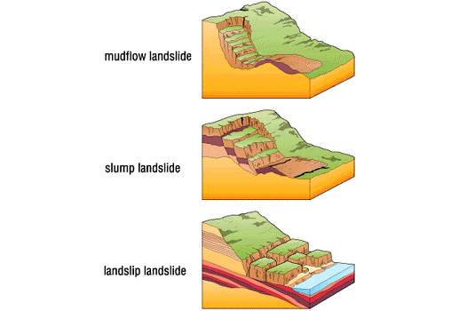
FLOWS: There are five basic categories of Flows: a. Debris flow b.
Debris avalanche c. Earthflow d. Mudflow e. Creep Across the road
from these coordinates, you will see the side of a small ridge that
has been cut away to make room for the road. In the side of the
exposed rock face you can see vertical drill marks where bore holes
were drilled. Explosives were placed into the bore holes, and the
subsequent blast fractured the rock. The broken pieces were cleared
away, leaving the rock face you see
now.
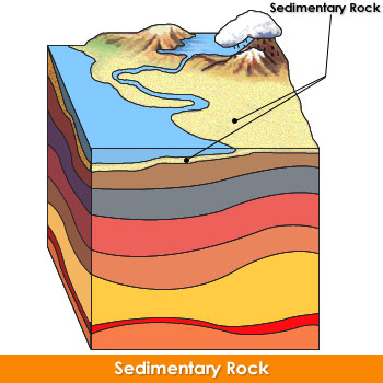
Do you see the various layers, or strata, visible in the rock
face? They aren’t horizontal, are they? No, the various layers of
earth and rock are angled. In addition to the angle, you will also
notice the layers are also tilted towards you. Mitigating A
Landslide In order to prevent (or mitigate) a landslide, one might
use one or more of the following actions: · avoiding construction
on steep slopes and existing landslides, · stabilizing the slopes.
· create a retaining structure, e.g. safety fence, retaining wall,
etc.
The Unaka Mountain
Range?
The Unaka Range is a mountain range on the border of Tennessee
and North Carolina, in the southeastern United States. It is a
subrange of the Appalachian Mountains and is part of the Blue Ridge
Mountains physiographic province. The Unakas stretch approximately
from the Nolichucky River to the south to the Watauga River to the
north. The Unakas include the prominent Roan Highlands, where
several summits rise above 6,000 feet. The Iron Mountains border
the Unakas to the north, and the Bald Mountains border the Unakas
opposite the Nolichucky to the south.[1] The name unaka is rooted
in the Cherokee term unega, meaning "white".(Wiki)

A Closer Look?
A look at rocks exposed in today's Appalachian mountains reveals
elongated belts of folded and thrust faulted marine sedimentary
rocks, volcanic rocks and slivers of ancient ocean floor, which
provides strong evidence that these rocks were deformed during
plate collision. The birth of the Appalachian ranges, some 300
million years ago, marks the first of several mountain building
plate collisions that culminated in the construction of the
supercontinent Pangaea with the Appalachians near the center.
Because North America and Africa were connected, the Appalachians
form part of the same mountain chain as the Anti-Atlas in Morocco.
To the northeast, the same mountain chain continues into Scotland,
from the North America/Europe collision. During the middle
Ordovician Period (about 496-440 million years ago), a change in
plate motions set the stage for the first Paleozoic mountain
building event (Taconic orogeny) in North America. The once-quiet
Appalachian passive margin changed to a very active plate boundary
when a neighboring oceanic plate, the Iapetus, collided with and
began sinking beneath the North American craton. With the birth of
this new subduction zone, the early Appalachians were born. Along
the continental margin, volcanoes grew, coincident with the
initiation of subduction. Thrust faulting uplifted and warped older
sedimentary rock laid down on the passive margin. As mountains
rose, erosion began to wear them down. Streams carried rock debris
down slope to be deposited in nearby lowlands. The Taconic Orogeny
was just the first of a series of mountain building plate
collisions that contributed to the formation of the Appalachians,
culminating in the collision of North America and Africa By the end
of the Mesozoic era, the Appalachian Mountains had been eroded to
an almost flat plain. It was not until the region was uplifted
during the Cenozoic Era that the distinctive topography of the
present formed. Uplift rejuvenated the streams, which rapidly
responded by cutting downward into the ancient bedrock. Some
streams flowed along weak layers that define the folds and faults
created many millions of years earlier. Other streams downcut so
rapidly that they cut right across the resistant folded rocks of
the mountain core, carving canyons across rock layers and geologic
structures.
Please do the following to get full
credit
1. When you log your visit, post a photo of you and your GPS
while you are at or near landslide area in the background. Group
photos are acceptable if each individual is identified by their
geocaching name. But the photo does not have be taken at posted
coords, anywhere on highway with the landslide site.
answers to the following questions: 2. What do you see that
might fall or slide off of the rock surface?
3. Which of the five landslide types listed above do you think
might occur here? Please give a brief explanation of your
choice
4. Name at least two safety items that should worn or used when
investigating a potential landslide area?