WELCOME TO THE BLACK MOUNTAIN SRING
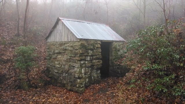
The coordinates above will take you to this cool little spring house where you will find the Black Mountain Spring. This is about .2 from the parking area and part of the 1.5 mile Black Mountain Loop Trail which intersects the Cumberland Trail.
The limestone bedrock of East Tennessee is one of the perfect ingredents for the formation of the karst topography of this area and Springs are a common sight. A spring is a water resource formed when the side of a hill, a valley bottom or other excavation intersects a flowing body of ground water at or below the local water table, below which the subsurface material is saturated with water. Water issuing from an artesian spring rises to a higher elevation than the top of the confined aquifer from which it issues. A spring is the result of an aquifer being filled to the point that the water overflows onto the land surface. They range in size from intermittent seeps, which flow only after much rain, to huge pools flowing hundreds of millions of gallons daily. Springs are not limited to the Earth's surface, though. Recently, scientists have discovered hot springs at depths of up to 2.5 kilometers in the oceans, generally along mid-ocean rifts (spreading ridges). The hot water (over 300 degrees Celsius) coming from these springs is also rich in minerals and sulfur, which results in a unique ecosystem where unusual and exotic sea life seems to thrive.
Springs may be formed in any sort of rock. Small ones are found in many places. In Tennessee (United States), the largest springs are formed in limestone and dolomite in the karst topography of the East Tennessee Mountain region. Both dolomite and limestone fracture relatively easily. When weak carbonic acid (formed by rainwater and carbon dioxide) enters these fractures it dissolves bedrock. When it reaches a horizontal crack. crevice or a layer of non-dissolving rock such as sandstone or shale, it begins to cut sideways. As the process continues, the water hollows out more rock, eventually creating airspaces, the largest of which are known as caves or caverns. This process frequently takes tens to hundreds of thousands of years to complete.
To get credit for this Earthcache you must email me the answers to the following questions:
(1) Take a picture of yourself and/or your group with GPS at the spring house.
(2) What is the temperature of the water in the ROUND pool inside the spring house (you will need a thermometer)
3) What is the depth of the ROUND pool inside the spring house (You will need a measuring device with numbers) no estimates!
4) There is a Kiosk about 50ft or so from the spring house. Answer the following questions from visitng this kiosk.
4-1)What segment of the Cumberland Trail is this?
4-2)Cox Valley Rd Trailhead is how far?
4-3)How far is the Black Mtn Campsite?
5) Is the water flowing out of the spring house clear or tea colored?
This cache can't be done at night! Please don't post your answers in your log.
Any "FOUND IT" log without your picture and without the correct answers emailed to me will be DELETED. Thanks and HAPPY CACHING!
