
How a Spit is Created
A spit is a deposition landform found off coasts. At one end, spits connect to land, while at the far end they exist in open water. A spit is a type of bar or beach that develops where a re-entrant occurs, such as at cove's headlands, by the process of longshore drift. Longshore drift (also called littoral drift) occurs due to waves meeting the beach at an oblique angle, and backwashing perpendicular to the shore, moving sediment down the beach in a zigzag pattern. Longshore drifting is complemented by longshore currents, which transport sediment through the water alongside the beach. These currents are set in motion by the same oblique angle of entering waves that causes littoral drift and transport sediment in a similar process.
Hydrology and Geology
Where the direction of the shore inland re-enters, or changes direction, such as at a headland, the longshore current spreads out or dissipates. No longer able to carry the full load, much of the sediment is dropped. This is also known as deposition. This submerged bar of sediment allows littoral drift to continue to transport in the direction the waves are breaking, forming an above-water spit.
Spits occur when longshore drift reaches a section of headland where the turn is greater than 30 degrees. They will continue out into the sea until water pressure (such as from a river) becomes too much to allow the sand to deposit. The spit may then be grown upon and become stable and often fertile. A spit may be considered a specialized form of a shoal. As spits grow, the water behind them is sheltered from wind and waves, and a salt marsh is likely to develop.
Wave refraction can occur at the end of a spit, carrying sediment around the end to form a hook or recurved spit.
The sediments that make up spits come from a variety of sources including rivers and eroding bluffs (like the Willemar Bluffs here), and changes there can have a large impact on spits and other coastal landforms. Activities such as logging and farming upstream can increase the sediment load of rivers, which may hurt the intertidal environments around spits by smothering delicate habitat. Roads or bulkheads built along bluffs can drastically reduce the volume of sediment eroded, so that not enough material is being pushed along to maintain a given spit.
If the supply of sediment is interrupted the sand at the neck (landward side) of the spit may be moved towards the head, eventually creating an island. If the supply isn't interrupted, and the spit isn't breached by the sea (or, if across an estuary, the river) the spit may become a bar, with both ends joined to land, and form a lagoon behind the bar. If an island lies offshore near where the coast changes direction and the spit continues to grow until it connects the island to the mainland, it is then called a tombolo.
The above information is from Wikipedia
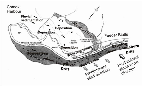
Goose Spit is one of the most beautiful sandy beaches in the region. A long neck of sand curves out into Comox Harbour, where a strong wind rises most afternoons, as winds funnel off the Strait of Georgia.
Natural features of Goose Spit include its unique landform, which together with Gartley Point, creates the Comox Harbour. It is a flexible sand spit fed by the Willemar Bluffs and is a Class I recreational beach. The inside is a sheltered lagoon. There are unique and rare plants and excellent views to the south and the east.
The park was first leased to the regional district for park purposes in 1971. The middle section of the spit is leased to H.M.C.S. Quadra and the end of the spit is an Indian Reserve. (from Comox Strathcona Regional District literature).
The spit is a natural landform created by currents travelling down the coast (or riverbank) and eroding sand particles along the way. A spit is formed when sand and pebbles are built out from the beach. As more materials are deposited because of the current, the spit grows further into the sea. The source of this sand and pebbles comes from upflow, in this case, up the strait.
The Willemar Bluffs area (home to the aforementioned homeowners) is being undercut by these same forces due to the installation of a sewer line up shore. This installation causes an acceleration of this erosion and has caused the bluffs to erode at an ever growing rate.
DND property is also being disturbed on the spit itself. Since a spit is “flexible” by nature, it is continually being eroded on its outside, with sediment hopefully being deposited on the leeward side (inside). This erosion is affecting the roadway on the spit to the point that DND took steps to prevent it.
At the coordinates you will see an example of the erosion of the Bluffs. Check out the aerial view of the spit in the gallery below.
Please post a picture of you and/or your GPSr with the bluffs in the background. This is not a requirement, but it is nice to see people at the site.
In order to claim this EarthCache, e-mail me with the following observations :
1- How high are the bluffs at this location?
2- What steps have been visibly taken to slow down or stop this erosion?
3- Are any houses visible on the bluff from this location?
4- Are there any other spits further up the coast that are being formed? (HINT - best place to see this is Google Maps/Earth. They are within a few kilometers of the spit).
5- Please post a photo of yourself or your GPS at the site. This is not a requirement, but always nice to see.

Brought to you by REDS Family Seekers (formerly) of Comox.
You may log your find before receiving confirmation from me, but any logs not meeting ALL the requirements mentioned will be deleted.
 Want to be further rewarded for visiting EarthCache sites around our planet? Then why not become involved in the exciting EarthCache Masters program. Just visit three or more EarthCache sites (view guidelines) to start being sent special EarthCache Masters graphics. There are four levels to strive to own - Bronze, Silver, Gold and Platinum. Its free and easy to participate! Come join in the fun.
To visit an Earthcache near you, click on the Earthcache Listings, and find a site that interests you.