|
   |
|
|
| Map |
 |
| Budapest |
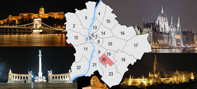
Budapest is a city of multiple characters, different geographical areas and of wide variety of architectural styles. The current city was established on 17th November, 1873 by the unification of the settlements of Pest, Buda and Óbuda on the banks of the Danube river. Budapest had 10 districts after coming into existence in 1873, numbered 1 to 10. In the 1930s, 4 new districts were organized, numbered 11 to 14. On 1st January, 1950, Budapest was united with 7 neighbouring towns and 16 villages, hence the number of its districts increased to 22. In 1994, one of the former villages left district 20 in order to form the 23rd district. Budapest's current 23 districts extend to an area of 525 square kilometres (202.7 sq mi). Most of the districts have a special flavour - from a posh downtown area one can get easily into the hilly districts of Buda or to the green suburbs of Pest. Several districts still bear the marks of the enforced industrialization of the 50s and 60s. City parks, forests of the Buda Hills, boat-houses along the Danube, flowery islands, shipyards and chemical plants, the Royal Castle and prefab housing estates are all part of this wonderful city.
The Great Budapest Geocaching Adventure guides you through all 23 districts with the goal of displaying the most typical or most unique sites in each of them. In each cache there is a code you need to uncover for the real coordinates of the bonus cache. You can find the codes on the inside of the lids of each cache container and in the logbooks. Happy caching. |
| 20th district |
| Pesterzsébet, the 20th district, was named after Queen Erzsébet, the spouse of Emperor Franz Joseph. The district is located in the southern part of Pest and the 7th biggest district of the capital. Its population is close to 65.000. The district is mostly a suburban area with a new center. |
 |
|
|
| The hiding place |
| The cache is hidden at the "Peace" Church. |
| Approaching |
 BUS 151 to Török Flóris utca(visit link). BUS 151 to Török Flóris utca(visit link).
 Accessible by bike (visit link) Accessible by bike (visit link)
 Free parking next to the cache Free parking next to the cache
|
| Budapest |
| Budapest ist eine Stadt bunten Charakters, unterschiedlicher geographischer Zonen und einer breiten Vielfalt an architektonischen Stilen. Die heutige Stadt wurde am 17. November 1873 durch Zusammenschluss der Städte Pest, Buda und Óbuda, die an beiden Ufern der Doanu liegen, gegründet. Budapest hatte damals 10 Bezirke, nummeriert von 1 bis 10. In den 30er-Jahren kamen 4 weitere Bezirke (11-14) hinzu. Am 1.Jänner 1950 wurde das Stadtgebiet um angrenzende 7 Städte und 16 Dörfer erweitert, die Zahl der Bezirke erhöhte sich damit auf 22. 1994 wurde eines der früheren Dörfer aus dem 20. Bezirk ausgegliedert, womit ein neuer 23. Bezirk enstand. Die derzeit 23 Bezirke haben eine Ausdehnung von insgesamt etwa 525km² (202,7mi²). Die meisten dieser Bezirke haben ihren unverwechselbaren Charakter - von repräsentativen Innenstadtbereichen über die hügeligen Bezirke von Buda bis hin zu den erholsamen grünen Vorstädten von Pest ist alles zu finden. Einige Bezirke stehen bis heute im Zeichen der stark forcierten Industrialisierung der 50er- und 60er-Jahre. Stadtparks, die Wälder der Budaer Berge, Bootshäuser entlang der Donauufer, blütengezierte Inseln, Werften und Chemiebetriebe, die königliche Burg und auch Fertigteil Wohnhausanlagen sind alle Teil dieser wundervollen Stadt. Das Große Budapester Geocaching Abenteuer wird durch jeden der 23 Bezirke führen und versuchen, in jedem etwas Typisches oder Einzigartiges zu zeigen. Jedem, der alle 23 Caches besucht, winkt als Draufgabe ein BONUS-Cache. Happy Caching. |
| Bezirk 20. |
| Die Pesterzsébet ist die Bezeichnung des 20. Bezirks in Budapest. Er liegt im südlichen Teil von Pest an der Donau. Pesterzsébet besteht überwiegend aus Wohngebäuden. Wirtschaftlich ist der Bezirk von untergeordneter Bedeutung. Eine wichtige Einrichtung ist das Ferenc Jahn – Krankenhaus, im Volksmund auch dél-pesti („Südpester“) Krankenhaus genannt. Im Nordwesten wird Pesterzsébet durch die Határ út vom Nachbarbezirk Ferencváros abgegrenzt. Im Nordosten bildet die Autobahn M5 die Trennlinie von Kispest. Der 23. Bezirk (Soroksár) ist der südliche Nachbar. Im Westen, am gegenüberliegenden Ufer der Donau, deren dortige Verzweigung Ráckever oder auch Soroksárer Donau genannt wird, befindet sich der 21. Bezirk(Csepel) auf der gleichnamigen Insel Csepel. Die beiden Stadtteile sind mit der Gubacsi-Brücke verbunden. Der 20. Bezirk ist in die Stadtteile Gubacsipuszta, Kossuthfalva, Pacsirtatelep, Pesterzsébet und Pesterzsébet-Szabótelepuntergliedert. Mit einem Anteil von 2,3% der gesamten Fläche der Stadt steht Pesterzsébet an 17. Stelle der 23 Bezirke. Hinsichtlich der Bevölkerungszahl befindet sich der Bezirk an 14. Stelle. Im Jahr 2003 waren 33.500 Personen erwerbstätig. Die Zahl der Rentner betrug 8.800. weitere info: http://de.wikipedia.org/wiki/Pesterzsébet. |
|
| Das Versteck |
| Die evangelische "Béke" Kirche in Pesterzsébet Neoromanische Kirche mit einige romantische Charakter. Arrangement: gegliedertes Seitenschiff mit einem Querschiff. Die Strebepfeiler sind gotisch, die Fensterform sind rumänisch. Das Grundriss des inneren Raumes ist sechseckig mit sternförmigem Gewölbe. . |
| Verkehrsverbindung |
mit dem Bus151bis Török Flóris utca(visit link).
Fahrrad-Zugang (visit link)
you can park free close to the cache
|
| Budapest |
| Budapest ezerarcú város, melyet földrajzi változatossága és építészeti sokszínusége varázsol egyedivé. Az 1873. november 17-én Pest Buda és Óbuda egyesítésével létrejött akkori fovárosnak 10 kerülete volt, amely az elkövetkezo évtizedek során fokozatosan bovült a mai 23-ra. A város ma 525 négyzetkilométeren terül el. A különbözo kerületek a folyamatos fejlodés és átalakulás mellett továbborzik sajátosságaikat, a Belváros csillogó bevásárló utcái, Buda dombvidéke vagy a pesti zöldövezet lakónegyedei mind sajátos hangulattal bírnak. A város arcát továbbra is sebhelyként csúfítják az 50-es 60-as évek eroltetett iparosításának "emlékmuvei". Zöld parkok és ligetek, a Budai hegyvidék erdoi, Duna-parti csónakházak, virágos szigetek, hajógyárak és vegyi üzemek, a Budavári palota és panel lakótelepek - ez mind Budapest. A Nagy Budapesti Geocaching Kaland végigvezet mind a 23 kerületen bemutatva az adott városrész legjellegzetesebb vagy éppen a legfurcsább vonását Ha mind a 23 ládát megtalálod, indulhatsz a BONUS csésze megkeresésére. Kalandra fel! |
| 20. kerület |
Pesterzsébet az (Erzsébet királynorol elnevezett) Erzsébetfalva és Kossuthfalva településekbol alakult az 1870-es években. Területe: 1.218 hektár. Mindez a fováros összterületének 2,3 százaléka, ezzel a hetedik legnagyobb kerület Budapesten. Pesterzsébet a Duna partját érintve, Dél-pesten helyezkedik el.
Öt városrészbol áll: Központi városrész, Gubacsi lakótelep és környéke, Erzsébetfalva, Kossuthfalva, Ipari negyed. Lakóinak száma : 64.576 (2006) Pesterzsébet nem tartozik a fovárosi muemlékekben, kirándulási lehetoségekben gazdag kerületek közé. A városrekonstrukció keretében az Óvárost nagyrészt lebontották, illetve átépítették. Említésre méltó a Csepeli átjáró mellett található, Magyarországon egyedülálló, sós-jódos melegvízu fürdo. Két kútja van: a termál 644 méter mélyrol 43 Co fokos vizet ad, valamint a sós-jódos, amely 112 méter mélyrol 15 Co fokos vizet ad.
A kerület történelme |
|
| A rejtek |
A Pesterzsébeti evangélikus "Béke" templom
Neoromán templom, néhány romantikát idézo jelleggel. Elrendezése: tagozott hosszhajó, egy kereszthajóval. Támpillérei gótikus, az ablakformák román jelleguek. Belso terének alaprajza hatszögu, csillagalakú boltozattal.
A templomról bovebben: Itt
|
| Megközelítés |
151-es busszal a Török Flóris utcáig. (menetrend).
Bicajjal megközelítheto (térkép)
Ingyenes parkolás a közelben
|