Overlooking the polders Multi-Cache
Please note Use of geocaching.com services is subject to the terms and conditions
in our disclaimer.
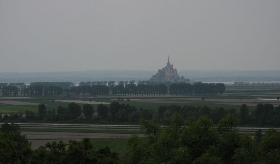
The Mount Saint Michel's bay is a testimony of the opposition of land and sea, of men and nature. The polders are an example of a temporary settlement that may change over times (remember that a forest was once surrounding the mount and that sea level is rising!).
- To have a nice view of Mount Saint Michel emerging from these flat lands, go to the nice panorama in the public garden of Roz-sur-Couesnon. Some displays in the garden present elements of the local history. Find the one dedicated to polders that explains how a system to provide the settlers with water was built in the XIXth century. Let A the altitude of the biggest water tank above the polders and B=A/10
- Then go to visit this tank at point N48 35.B28 W1 35.BB7. Access from the south is not allowed anymore by local landowners, please approach the point from NNW for 150 meters (waypoint TW). Let C be the number of gates to let the water out of the big tank and down pipes to the polders. Let D=A/6 and E=C*2
- You can follow the water direction to get nearer the final cache location at point N48 35.EEE W1 35.ED(B+C-D)
From there you can follow the GR34 path for hundreds of kilometers to the south of Brittany or just walk on one of the local paths, like for exemple the one that goes past the first of nearly fifty guards' house (point N48 35.551 W1 36.020) that used to protect this area for sea invaders in the XVIIIth century.
La baie du Mont Saint Michel voit s'affronter la terre et l'eau, l'homme et la nature. Les polders que domine le Mount sont un exemple d'un statu quo temporaire concrétisé par des digues et des canaux (n'oublions pas que des forêts entouraient le Mount dans le passé et que le niveau des mers monte doucement grâce à nous!)
- Pour avoir une belle vue sur le Mont émergeant des polders, visitez le jardin public devant la mairie de Roz sur Couesnon. Des panneaux expliquent quelques points d'histoire locale. Trouvez celui concernant les polders présentant notamment le système d'adduction d'eau construit au XIXème pour alimenter les fermes des colons. Notez A le dénivellé entre le niveau des polders et celui du grand réservoir. Soit B=A/10
- Allez ensuite admirer ce réservoir au point N48 35.B28 W1 35.BB7. L'accès par le sud n'est plus autorisé par les propriétaires voisins, arrivez par le Nord-Nord-Ouest sur environ 150 mètres (point TW). Soit C le nombre de vannes libérant l'eau du réservoir pour alimenter les polders. Soit D=A/6 et E=C*2
- Commencez par suivre le trajet de l'eau puis trouvez la cache au point N48 35.EEE W1 35.ED(B+C-D)
Vous pouvez poursuivre votre promenade sur le GR34 ou d'autres sentiers des environs comme par exemple celui qui redescend dans la baie en passant à proximité d'un des anciens corps de garde (point N48 35.551 W1 36.020), le premier d'une cinquantaine construits au XVIIIème) pour protéger la côte des invasions ennemies.
|
|

Additional Hints
(Decrypt)
Nh qéohg qh cvreevre, qnaf har crgvgr genapuér, qreevèer har fbhpur qr obvf zbeg.
Ng gur obggbz bs gur fybcr, oruvaq n fznyy ehvarq jnyy naq n fghzc.
Treasures
You'll collect a digital Treasure from one of these collections when you find and log this geocache:

Loading Treasures