My Sediments
Exactly!!
First
and foremost: Access to the cache site is not
recommended during the Spring months where snowpack runoff is
high. This Earthcache is located along the creek which can
be hazardous during high water flow, but the area is very
impressive non the less. The site is accessible from either side of
the creek during the summer months when the water flow is low. The
easiest access is from the Pioneer Trail on the West side of the
creek (Some rock scrambling required). Parking is available where
Bowman Road crosses the creek to the south of the site. This is
also a VERY POPULAR swimming
hole so bring your suit!!
The
formation of the Earth is a slow and complicated process. But you
can find a record of the process just about everywhere, if you know
what you are looking for. In the case if this earthcache, the
results of sediment deposition can be observed.
Sedimentary rocks contain important information
about the history of Earth. They sometimes contain fossils, the
preserved remains of ancient plants and animals. Coal is considered
a type of sedimentary rock. The composition of sediments provides
us with clues as to the original rock. Differences between
successive layers indicate changes to the environment which have
occurred over time and sometimes the type of material deposited.
Sedimentary rocks can contain fossils because, unlike most igneous
and metamorphic rocks, they form at temperatures and pressures that
do not destroy fossil remains.
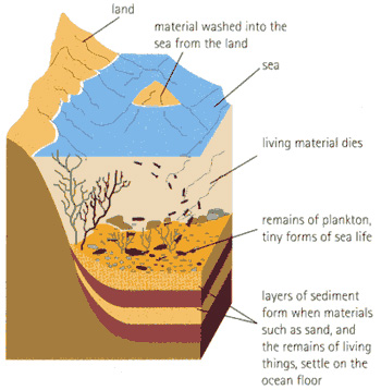
Formation of Sedimentary rock is an easy process
to understand. Very small particles of materials are suspended in
water, like a river or stream, and are carried down stream until
the water flow can no longer carry the material. This sediment can
be smaller pieces of broken rocks, sand, or pieces of lighter
materials, like dead animals or plant parts. When the water flow
slows to the point on not being able to carry the material it
settles to the bottom in a layer. (See Diagram for an illustration)
Sediments can also be carried by the wind if light enough. The only
difference is that the sediments get deposited in an area where the
wind current slow to the point of not being able to carry the
material anymore.
The
sedimentary rock cover of the continents of the Earth's crust is
extensive, but the total contribution of sedimentary rocks is
estimated to be only 5% of the total. As such, the sedimentary
sequences we see represent only a thin veneer over a crust
consisting mainly of igneous and metamorphic rocks.
About
this site: At this Earthcache location you can observe the
resulting sedimentary rock formation created by the process above.
This example has been brought to the surface thought the formation
of the Sierra Nevada Mountains. The formation has been further
exposed by the creek bed in which it resides. The water from the
creek has washed away the loose rock (continuing the cycle of
creating a new generation of sedimentary rock further down stream)
to expose the layers of this location. The layers of rock at this
location are of a higher density than typical sandstone, however,
you can observe that the hardness of the layers varies. This is
evident from the erosion present due to the water flow of the
stream. The softer the layer, the deeper is it eroded. You will
also notice the "orientation" of the layers. This was caused by the
rising of the earth crust in the formation of the surrounding
mountains.
To log this cache: (Email me the
answers)
-
At
the given coordinates you can see three main layers of rocks. What
is the difference between the middle gray layer as compared to the
layers on either side? I am looking for anything but color here.
Consistency/texture, the effects of erosion, etc.
-
Estimate the width of this
layer.
-
Explain the "orientation" of this sedimentary
rock formation in relation to the horizon. (Horizontal, vertical,
diagonal?)
-
Do
you think this orientation influences the direction of the creek
flow. Yes, or no and why?
 Remember, Practice "Cache In Trash Out"
While out geocaching, bring a bag with you to
pick up trash along the way.
Visit the Cache In Trash Out page to learn more
about CITO.
CITO Logo use granted
3/28/08 by Groundspeak BTG-708616