From the guidelines, as from January 2013: "People do not need to wait for permission to log your EarthCache. Requiring someone to wait is not supported by the EarthCache guidelines. People should send their logging task answers to you, then log your EarthCache. When you review their logging task answers, if there is a problem, you should contact them to resolve it. If there is no problem, then their log simply stands."

Introduction:
The English name "Alps" was taken via French from Latin Alpes, which may be ultimately cognate with Latin albus ("white"). The Alps are a mountain system located in south-central Europe, to the immediate north of the Mediterranean Sea. They extend for almost 700 miles in a crescent shape from the coastline of southern France (near Monaco) into Switzerland, then through northern Italy and into Austria, and down through 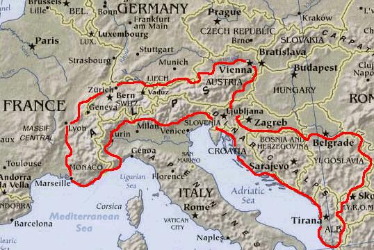 Slovenia, Croatia, Bosnia and Herzegovina, Serbia and Montenegro - then ending in Albania on the rugged coastline of the Adriatic Sea.
Geography:
The Alps are generally divided into the Western Alps and the Eastern Alps. The division is along the line between Lake Constance and Lake Como, following the rivers Rhine, Liro and Mera. The Western Alps are higher, but their central chain is shorter and curved; they are located in Italy, France and Switzerland. The Eastern Alps (main ridge system elongated and broad) belong to Italy, Austria, Switzerland, Germany, Liechtenstein and Slovenia. The highest peak of the Western Alps is Mont Blanc, at 4,808 metres (15,774 ft). The highest peak of the Eastern Alps is Piz Bernina, at 4,049 metres (13,284 ft).

The eastern Alps
From the Maloja Pass the main watershed dips to the south-east for a short distance, and then runs eastwards and nearly over the highest summit of the Bernina Range, Piz Bernina (4049 m), to the Bernina Pass. Then to the Reschen Pass the main chain is ill-defined, though on it rises the Corno di Campo (3305 m), beyond which it runs slightly north-east past the sources of the Adda and the Fraele Pass, sinks to form the depression of the Ofen Pass, soon heads north and rises once more in the Piz Sesvenna (3221 m).
The break in the continuity of the Alpine chain marked by the deep valley, the Vinschgau, of the upper Adige (Etsch) is one of the most remarkable features in the orography of the Alps. The little Reschen Lake, which forms the chief source of the Adige is only 4 metres below the Reschen Scheideck Pass (1494 m), and by it is but 5 miles (8 km) from the Inn valley. Eastward of this pass, the main chain runs north-east to the Brenner Pass along the snowy crest of the Ötztal and Stubai Alps, the loftiest point on it being the Weißkugel (3746 m, Ötztal), for the highest summits both of the Ötztal and of the Stubai districts, the Wildspitze (3774 m) and the Zuckerhütl (3511 m) stand a little to the north.
The Brenner (1370 m) is almost the lowest of all the great Carriage-road passes across the main chain, and has always been the chief means of communication between Germany and Italy. For some way beyond it the watershed runs eastwards over the highest crest of the Zillertal Alps, which attains 3523 metres in the Hochfeiler. But, a little farther, at the Dreiherrenspitze (3505 m), the chain splits, and it is unclear whether the higher peaks branching off to the south or the smaller divide that continues on the same eastward path as the earlier mountains should be considered the main chain.
The Eastern Alps are commonly subdivided according to the different lithology (rock composition) of the more central parts of the Alps and the groups at its northern and southern fringes:
The border between the Central Alps and the Southern Limestone Alps is the Periadriatic Seam. The Northern Limestone Alps are separated from the Central Eastern Alps by the Graywacke Zone.
 The western Alps
Starting from the Col d'Altare or di Cadibona (west of Savona), the main chain extends first south-west, then north-west to the Col de Tenda, though nowhere rising much beyond the zone of coniferous trees. Beyond the Col de Tenda the direction is first roughly west, then north-west to the Rocher des Trois Eveques (2840 m), just south of the Mont Enchastraye (2932 m), several peaks of about 3000 metres rising on the watershed, though the highest of all, the Punta dell' Argentera (3265 m) stands a little way to its north. From the Rocher des Trois Eveques the water divide runs due north for a long distance, though of the two loftiest peaks of this region one, the Aiguille de Chambeyron (3373 m), is just to the west, and the other, the Monte Viso (3813 m), is just to the east of the divide. From the head of the Val Pelline the main chain runs north-west, and diminishes much in average height until it reaches the Mont Thabor (3157 m), which forms the apex of a salient angle which the main chain here presents towards the west. From here the divide extends eastwards, culminating in the Aiguille de Scolette (3478 m), but makes a great curve to the north-west and back to the south-east before rising in the Rochemelon (3509 m). From there the direction taken is north as far as the eastern summit (3536 m) of the Levanna, the divide rising in a series of snowy peaks, though the loftiest point of the region, the Pointe de Charbonel (3730 m), stands a little to the west. Once more the chain bends to the north-west, rising in several lofty peaks (the highest is the Aiguille de la Grande Sassiere, 3726 m), before attaining the considerable depression of the Petit Saint Bernard Pass.
The divide then briefly turns north to the Col de la Soigne, and then north-east along the crest of the Mont Blanc chain, which culminates in the peak of Mont Blanc (4807 m), the loftiest in the Alps. A number of high peaks line the divide before it attains Mont Dolent (3823 m). From there, after a short dip to the south-east, the chain takes, near the Grande Saint Bernard Pass, the generally eastern direction that it maintains until it reaches Monte Rosa, whence it bends northwards, making one small dip to the east as far as the Simplon Pass. It is in the portion of the watershed between the Grande St Bernard Pass and the Simplon that the main chain maintains a greater average height than in any other part. But, though it rises in a number of lofty peaks, such as the Mont Velan (3736 m), the Matterhorn (4470 m), the Lyskamm (4502 m), the Nord End of Monte Rosa (4575 m), and the Weissmies (4000 m), many of the highest points of the region, such as the Grand Combin (4283 m), the Dent Blanche (4330 m), the Weisshorn (4477 m), the true summit or Dufourspitze (4602 m) of Monte Rosa itself, and the Dom (4518 m), all rise on its northern slope and not on the main chain. On the other hand the chain between the Grande St Bernard and the Simplon sinks at barely half a dozen points below a level of 3000 metres. The Simplon Pass corresponds to what may be called a dislocation of the main chain. From there to the St. Gotthard the divide runs north-east, all the higher summits (including the Monte Leone, 3533 metres, and the Pizzo Rotondo, 3172 m) rising on it, a curious contrast to the long stretch just described. From the St Gotthard to the Maloja the watershed between the basins of the Rhine and Po runs in an easterly direction as a whole, though making two great dips towards the south, first to near the Vogelberg (3220 m) and again to near the Pizzo Gailegione (3085 m), so that it presents a broken and irregular appearance. But all the loftiest peaks rise on it: Scopi (3175 m), Piz Medel (3178 m), the Rheinwaldhorn (3371 m), the Tambohorn (3250 m) and Piz Timun (3176 m).
The Western Alps are commonly subdivided with respect to geography:
Series of lower mountain ranges run parallel to the main chain of the Alps, including the French Prealps.
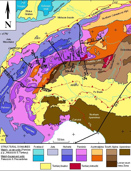
The geologic subdivision is different and makes no difference between the Western and Eastern Alps: the Helveticum in the north, the Penninicum and Austroalpine system in the center and, south of the Periadriatic Seam, the Southern Alpine system and parts of the Dinarides (see Alpine geology). Geographically, the Jura Mountains do not belong to the Alps; geologically, however, they do.
Geology:
The Alps form a part of a Tertiary orogenic belt of mountain chains, called the Alpide belt that stretches through southern Europe and Asia from the Atlantic all the way to the Himalayas. This belt of mountain chains was formed during the Alpine orogeny. A gap in these mountain chains in central Europe separates the Alps from the Carpathians off to the east. Orogeny took place continuously and tectonic subsidence is to blame for the gaps in between.
The Alps arose as a result of the collision of the African and European tectonic plates, in which the western part of the Tethys Ocean, which was formerly in between these continents, disappeared. Enormous stress was exerted on sediments of the Tethys Ocean basin and its Mesozoic and early Cenozoic strata were pushed against the stable Eurasian landmass by the northward-moving African landmass. Most of this occurred during the Oligocene and Miocene epochs. The pressure formed great recumbent folds, or nappes, that rose out of what had become the Tethys Sea and pushed northward, often breaking and sliding one over the other to form gigantic thrust faults. Crystalline basement rocks, which are exposed in the higher central regions, are the rocks forming Mont Blanc, the Matterhorn, and high peaks in the Pennine Alps and Hohe Tauern.
The formation of the Mediterranean Sea is a more recent development, and does not mark the northern shore of the African landmass.
The EarthCache
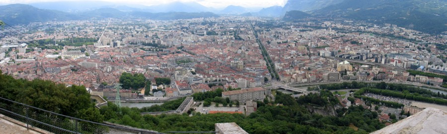
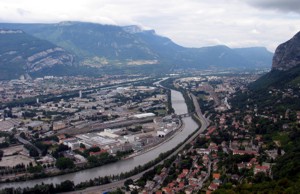
This earthcache takes you to a lookout point where you can observe the Alps in SE France, in particular the Vercors plateau.
 The Vercors plateau
The Vercors is a plateau in the départements of Isère and Drôme in Eastern France that began as a flatish reef platform subsequently faulted and folded. It is one of the ranges that form the French Prealps. It lies west from the Dauphiné Alps, from which it is separated by the rivers Drac and Isère. The cliffs at its eastern edge face the city of Grenoble. It comprises several resorts for cross-country skiing and for down-hill skiing as well.
 Claiming the EarthCache
Go to the supplied coordinates and answer the following questions:
1- How long ago did the reef platform develop?
2- Looking west you can see the evidence of two major faults. What are their names?
3- What are the names of the prominent geologists who contributed to the geology of the alps?
4- The Urgonian limestone is now broken up into how many panels?
5- Add a picture of yourself with the Vercors as backdrop (OPTIONAL).
E-mail me the answers in English to the above questions and log the cache. In the event of wrong answers or it not fulfilling all the requirements of this EC, your log will be deleted.
Note: Platinum EarthCache level "ribbon" courtesy of Play mobil.
References:
http://en.wikipedia.org/wiki/Alps
http://en.wikipedia.org/wiki/Main_chain_of_the_Alps
http://en.wikipedia.org/wiki/Vercors_Plateau

 The most exciting way to learn about the Earth and its processes is to get into the outdoors and experience it first-hand. Visiting an Earthcache is a great outdoor activity the whole family can enjoy. An Earthcache is a special place that people can visit to learn about a unique geoscience feature or aspect of our Earth. Earthcaches include a set of educational notes and the details about where to find the location (latitude and longitude). Visitors to Earthcaches can see how our planet has been shaped by geological processes, how we manage the resources and how scientists gather evidence to learn about the Earth. To find out more click HERE.
FTF by YOYOMAN38 - Well done!
STF by VILCANOTA