
 Access to the waypoints of this EarthCache requires travel up the Whitaker Peak Fire road. This fire road is locked but can be hiked or biked. An Adventure Pass is required to park along the road. With advance planning, you could get the key from the Forest service and drive it.
Relative movement between the North American and Pacific Plates became transform about 20 million years ago forming the San Andreas Fault Zone (SAFZ). The SAFZ is a series of individual faults that together create the movement between the two plates. Faults that are associated with the same the same relative motion between two blocks of rock (entire plates in this case) are often called strands of the larger fault zone. These strands can be separated by a few feet to miles.
Often one of the strands makes up the majority of the motion in a fault zone. However main strand does not remain constant over time. In this area, the San Gabriel Fault was the predominant strand of the SAFZ from about 11 million to 4 million years ago (Late Mioceneand Early Pliocene). Since then, the majority of the movement moved over to the San Andreas Fault a few miles to the east.
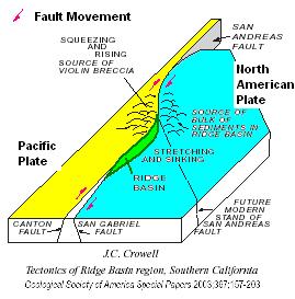 Due to the differences between the relative movement between strands in a fault zone, the areas between the strands often undergo elevation changes. In this area, the area east of the San Gabriel Fault began to form a deep basin called the Ridge Basin. The Ridge Basin is about 24 miles long, 6 miles wide and about 8 miles deep. Erosion of the surrounding mountains filled the basin with a variety of rock types based on their distance from the San Gabriel Fault and the energy of eroding water. These rock types can be observed at various other EarthCaches in the area.
At this location the San Gabriel Fault has placed the Violin Breccia adjacent to Proterozoic gneiss (the Proterozic ranges from 2500 to 542.0 million years ago) and the Violin Breccia was deposited from about 11 to 4 million years ago. Continuing west, additional faults then expose quartz monzonite and even older gneiss in the road cuts on the other side of the saddle. These other faults are actually a little easier to see than the San Gabriel Fault since movement along the San Gabriel Fault created a zone of fault gouge (broken up rock along a fault) that is easily eroded and covers the fault itself.
Pieces of the gneiss and monzonite can be found in the Violin Breccia as the breccia formed form sediment eroded of ancient highlands on the west side of the San Gabriel Fault when it was active.
From the saddle, you can see a relatively linear valley that marks the general trace of the San Gabriel Fault.
Logging requirements:
Send me a note with :
- The text "GC1W5HG The San Gabriel Fault along the Ridge Basin" on the first line
- The number of people in your group.
- What general direction does the linear valley of the San Gabriel Fault go?
- Based on the change from the Violin Breccia (a rock made up of large angular pieces of other rock) to Gneiss a relatively uniform white rock sometimes with thin dark bands), where is the San Gabriel Fault in relation to the middle of the Saddle?
Advanced Questions (requires geologic background/rock identification):
- Can you identify the fault gouge?
- Can you identify pieces of the basement rock that is exposed on the west side of the San Gabriel Fault in the Violin Breccia exposed on the east side of the Fault ??
The following sources were used to generate this cache:
- Link, M.H., and Crowell, J.C., 2003, Guide to field stops, Ridge Basin, southern California, in Crowell, J.C., ed., Evolution of Ridge Basin, southern California: Aninterplay of sedimentation and tectonics: Boulder, Colorado, Geological Society of America Special Paper 367, p. 205–247. © 2003 Geological Society of America
- Crowell, 2003, Introduction to geology of Ridge Basin, Southern California, Geological Society of America Special Paper 367, 2003
- Crowell, 2003, Tectonics of Ridge Basin region, Southern California, Geological Society of America Special Paper 367, 2003