An EarthCache featuring the 1931 Hawke's Bay Earthquake, also known as the Napier Earthquake. This involves a walk around Napier’s CBD which takes you to several signboards where you will find interesting information about the earthquake.
The given co-ords take you to the first signboard, and from there you should easily be able to find the rest. At each board you will be required to gain some information and supply answers. The terrain is flat and suitable for wheelchairs.
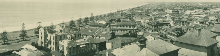 Napier 1929 before the earthquake
BACKGROUND
The earthquake occurred at 10:47 am on Tuesday February 3 1931, killing 256 and devastating the Hawke's Bay region. Centered 15 km north of Napier, it lasted for two and a half minutes and measured about 7.8 on the Richter scale. There were 525 aftershocks recorded in the following two weeks. The main shock could be felt in much of the lower half of the North Island. Nearly all buildings in the central areas of Napier and Hastings were levelled (The Dominion noted that "Napier as a town has been wiped off the map") and the death toll included 161 people in Napier, 93 in Hastings, and two in Wairoa. Thousands more were injured, with over 400 hospitalised.
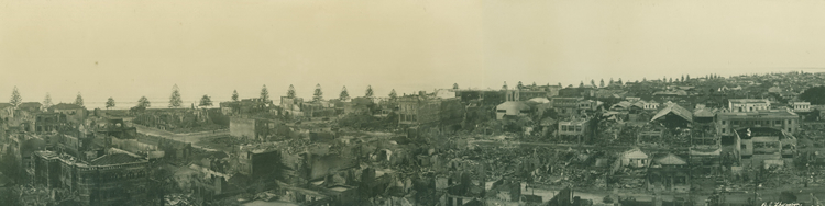 Napier after the earthquake 1931
The local landscape changed dramatically, with the coastal areas around Napier being lifted by around two metres. Some 40 km² of sea-bed became dry land, where the airport, housing and industrial property developments now exist. The most noticeable land change was the uplifting of the Ahuriri Lagoon. The lagoon was lifted more than 2.7 metres, which resulted in draining 2230 hectares of the lagoon. Today, the area is where farmland and the Hawkes Bay Airport are located. The earthquake prompted a thorough review of New Zealand building codes, which were found to be totally inadequate. Many buildings built during the 1930s and 1940s are heavily reinforced, although more recent research has developed other strengthening techniques. To this day there are few buildings in Hawke's Bay taller than five stories, and as most of Napier's rebuilding took place in the 1930s when Art Deco was fashionable, Napier architecture is regarded today as being one of the finest examples of Art Deco in New Zealand. Hastings was also rebuilt with many Art Deco and Spanish Mission style buildings.
GEOLOGY
Scientists now know that this earthquake occurred on a buried, or blind thrust, fault. These are earthquake-generating faults that do not extend up to the earth's surface and they occur in most of the tectonic plate boundary zones of the world. As well as being hidden, blind thrust faults also pack a big punch when they rupture. Because the two sides of a thrust fault are being compressed like a vice, it takes a lot of energy to rip them apart.

The explosive release of this energy produces high intensity ground-shaking, and scientists consider them to be a particularly lethal type of geological fault because they show little or no evidence at the surface and, even when detected, are difficult to study.
Such faults, being invisible at the surface, have not been mapped by standard surface geological mapping. Sometimes they are discovered as a by-product of oil exploration seismology; in other cases their existence is not suspected. These blind thrust faults are predominant on the North Island's east coast between Wairarapa and East Cape.
Although such earthquakes are not amongst the most energetic, they are sometimes the most destructive, as conditions combine to form an urban earthquake which greatly affects urban seismic risk. It is said that blind thrust earthquakes contribute more to urban seismic risk than the 'big ones' of magnitude 8 or more. This was definitely the case in the Napier earthquake.
To log this EarthCache, you must visit each signboard. Once you complete the following EarthCache requirements you can post your find without delay, as per the EarthCache guidelines. You will also need to verify your find by sending us a message with your answers to these questions and we will answer in due course:
1. Use the text "Napier Earthquake - GC1WG2N" in your email.
2a. In one of the photos, who was working in the wreckage of a building which stood on the site of the present T & G building?
2b. What was the first new building to rise in Napier?
2c. What building stood at the bend of Shakespeare Road?
2d. What was the date that fires raged in Napier’s business area and Ahuriri?
2e. Which church was almost completed when the Earthquake struck?
2f. What did the front section of the fire station get built in?
3. We referred above to Tectonic Plates - How many major plates are there on Earth and which two are the ones that create so many earthquakes in New Zealand?
4. Blind thrust fault earthquakes, as described above, can be the most destructive type of quakes. Napier changed dramatically after this and there are at least two earth features that were substantially affected as a consequence of this quake. They are visible from one or more of the signboards. Describe one of these.
5. (Optional). At one of the signboards take a photo of yourself or one of your party with gps and post it with your log.
Please DO NOT post answers with your log. Just post your photo.