What's An Esker?
An esker is a glacial landform. Eskers are believed to be
created during a glacier's retreat. Meltwater flows inside tunnels
within or beneath the glacier, depositing sediments (boulders,
gravel, sand) as it flows. The tunnels within the ice gradually
fill up with sediments. As the glacier retreats, the sediment
within these ice tunnels is left behind, forming ridges. The word
esker comes from the old Irish word for “ridge.”
Formation and Special Features of the Norwood Esker
Many of the land features around Peterborough, including eskers,
drumlins, and moraines, were formed during the Wisconsian
Glaciation.
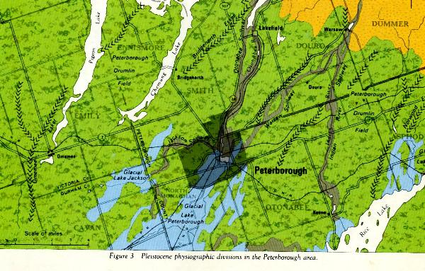
This image shows several eskers in the Peterborough area. Thanks
to JUNGLE J for sending me this gem from a 1967 Ontario Department
of Mines publication called "Geology and
Scenery-Peterborough,Bancroft, and Madoc Area."
Eskers left by streams at the bottom of glaciers are called
subglacial eskers. These eskers tend to be continuous ridges with a
consistent, unbroken form and stratified layers of sediment. When
the stream ran through the glacier, rather than beneath it, the
sediments become disrupted as the glacier melts and retreats. The
eskers that result are known as englacial eskers. Their form is
more broken, and the sediments are not as neatly stratified.
Eskers are interesting and useful for several reasons. Their
size, shape, and composition can give us clues about the speed and
direction of a glacier's retreat. They are also good aquifers
– their composition is highly porous, so they can hold large
quantities of water. The layers of sand and gravel also act as a
huge filter, so the water from eskers is often very clean. Eskers
can be quarried for rock, gravel, and sand. Because they are often
elevated, eskers have been long been used as roads.
The Norwood Esker in particular is significant to the community
of Norwood, not just for its imposing form upon which much of the
village is built, but because it is the main source of water for
the village and it has great potential as a source for aggregates
(gravel, sand, etc.).
Here is a list of websites with further information about the
Norwood esker:
Ontario
Ministry of Natural Resources Natural Areas Report: NORWOOD ESKER
COMPLEX
The Township
of Asphodel-Norwood
Canadian
Landform Inventory Project
Finding and Logging the Earthcache
The suggested waypoints will bring you to two particular points
of interest. One is the Norwood Pond, situated on the esker. The
other brings you to the roadside next to a quarry in the esker,
where the esker's composition is easily discerned. The quarry is
private property, so please observe the site from the roadside.
To log a find on this Earthcache, visit both waypoints and
complete the following requirements. It's okay to do this as a
group, but please write your responses in your own words. Email
your responses - don't post them in your log!
1.Take an elevation reading on your GPS at both of the
sites.
2.Do you think this was an englacial or a subglacial esker?
Why?
3.The two major potential uses for this esker are clean water
for the community, and aggregate materials. Why might these two
uses conflict with each other?
Don't worry about getting these questions right or wrong, just
make the best observations you can and give me thoughtful
answers.
Pictures with logs are always appreciated!
Here are some other Earthcaches that will teach you more about
some of the topics mentioned here:
GC1EXK1 - The Bridgenorth Esker - Located near Peterborough,
ON, this Earthcache will show you a different esker formed at the
end of the last ice age.
GC1QC1G - The Vars-Winchester Esker - Situated east of Ottawa,
ON, this esker was submerged in the Champlain Sea and left buried
in mud when the sea retreated 10000 years ago.
GC15AM7 - Peterborough Drumlin Fields - Drumlins are another
local land feature formed by glacial sediments. You should be able
to easily spot a suitable drumlin along highway 7 between Keene and
Norwood in order to fulfill the requirements of this
Earthcache.
GC1JN3K - Oak Ridges Moraine Earthcache - The Oak Ridges
Moraine is one of Southern Ontario's most significant geological
landforms - another remnant of the Wisconsin Glaciation.
Visit my geocaching blog! geonarcissa.wordpress.com