
The Copper Creek Thrust Fault
The Cumberland Mountain sits on top of the horizontal Pine
Mountain Thrust sheet. Sedimentary rocks that dip in the opposite
directions underlie the Pine Mountain Thrust Sheet. The Pine
Mountain Interaction between the faults takes place via ramping of
the hanging-walls on top of adjacent footwalls. The Pine Mountain
ramps twice, the first of which results in the Powell Valley
Anticline-Middlesboro Syncline pair. The Copper Creek Thrust Fault
is another thrust fault located in the Pine Mountain Thrust
sheet.

Pangaea
Like all structures in the Appalachian fold and thrust
belt, the Pine Mountain Thrust resulted from the Alleghanian
Orogeny. Just what was this Alleghanian Orogeny? The Alleghenian
orogeny is one of the geological mountain-forming events (an
orogeny) that formed the Appalachian Mountains. Approximately 350
million to 300 million years ago, in the Carboniferous period, when
Gondwana (later to become Africa) and what became North America
collided, forming the super continent, Pangaea. This collision
exerted massive stress on what is today the Eastern Seaboard of
North America, resulting in a large-scale uplift of the entire
region. With the creation of the mountains came the creation of
many, many faults. The Copper Creek Fault is but one of the many
faults.
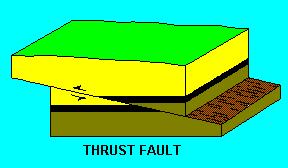
The Copper Creek Thrust Fault is significant and unique
since the lithology north of the fault is younger, while south of
the fault is older. Since younger beds are on top of older ones at
this location, this makes it is a classic thrust fault. The lower
‘layers’ of the fault are composed of the Moccasin
Formation, which are massively bedded dolomite that is overlain by
sandstone, siltstone and shale. The upper layers are the Rome
formation which is the younger of the two. The Moccasin formation
is a limestone with some uncharacteristic colors. The older rock
type that is part of the Rome Formation, is Cambrian in age (540 to
490 million years ago), while the younger rock type that is part of
the Moccasin Formation is Ordovician in age (490 to 443 million
years ago).
Thrust Fault Formation
Evidence of ductile and brittle deformation is apparent at
the Copper Creek road cut. The Moccasin is a stronger limestone
than the Rome, since it is not deformed. While numerous fractures
are evident in the Moccasin limestone, the Rome limestone shows
ductile folding has occurred. Beside observing younger rocks
sitting on top of older rocks be sure to view the landslide scar.
This scar can be found on the above photo at the lower right
quadrant. The slide probably occurred when the road was widened and
the rock mass was trucked away. In a way, at this location there
are two types of EarthCaches: one a major thrust fault and another
is evidence of a landslide. Sorry, but you only get credit for
one!
NOTE: For you to get that credit, you must complete these tasks:
1. Email answers to the following questions: A. Using the
road as the base what is the degree of slope of the Fault? Answers
are only accepted within 10 degrees! You may want to bring a
protractor! B. Estimate the total length of the visible
fault. C. Describe the major colors found in the upper
Moccasin formation and in the lower Rome formation. 2. Post
a photo of you or your GPSr pointing to the fault line. Showing
your face(s) in the photo is preferred but if there hesitation to
do so, then a photo with the GPSr and fault will be acceptable.
Enjoy this wonderful example of a very visible thrust fault
and take lots of pictures!
This Earthcache was approved by the
Geological Society of America
| We have earned GSA's highest level: |
 |