Beach
sediments that accumulate along the sea or lake shores, the
configuration and contours of which depend on the action of coastal
processes, the kinds of sediment involved, and the rate of delivery
of this sediment. There are three different kinds of beaches. The
first occurs as a sediment strip bordering a rocky or cliffy coast;
the second is the outer margin of a plain of marine or fluvial
accumulation (free beaches); and the third, of fairly peculiar
character, consists of the narrow sediment barriers stretching for
dozens or even hundreds of kilometres parallel to the general
direction of the coast. These barriers separate lagoons from the
open sea and generally are dissected by some tidal inlets. Certain
sediment forelands, such as spits, points, and tombolos (which
connect an island with a mainland), also occasionally are called
beaches
The profile of an active beach varies greatly. Its form and
dimensions depend on a number of factors, such as wave parameters,
tide height, and sediment composition and distribution.Some minor
relief forms are usually present on the surface of sand beaches.
These include oscillation ripples, swash or rill furrows, and the
well-known beach cusps (concave seaward) at the beach
margin.
Sand is a scarce resource near Myrtle Beach The beaches are thin
ribbons of sand that sit on top of sedimentary rocks. They receive
little or no sand from nearby rivers. Offshore, there is little
sand to wash ashore and replenish the beach. Large expanses
offshore are exposed as hard grounds that are locally overlain by
sand less than 3 feet thick. Sand is transported primarily from
northeast to southwest in the area. Large sand deposits have
accumulated seaward of Murrell’s Inlet and Winyah Bay, SC. These
and other sand deposits could serve as offshore sources of beach
nourishment in the future. Effective beach management requires a
regional, systematic effort to understand the geology and how it
constrains sand supplies and sand movement, determine patterns of
shoreline change by surveying beaches at regular intervals over
several years and identify ocean processes that drive coastal
erosion. A detailed record of coastal change provides guidance for
land use and a rationale for development decisions such as
determining setbacks necessary to protect property. Climate change
will affect many beaches; low elevation beaches are vulnerable over
greater inland areas.
Swash
The upper limit of the active beach is the swash line reached by
highest sea level during big storms. The lower beach margin is
beneath the water surface and can be determined only if there is a
definite border present between the sediment layer and the naked
surface of the rocky bench.
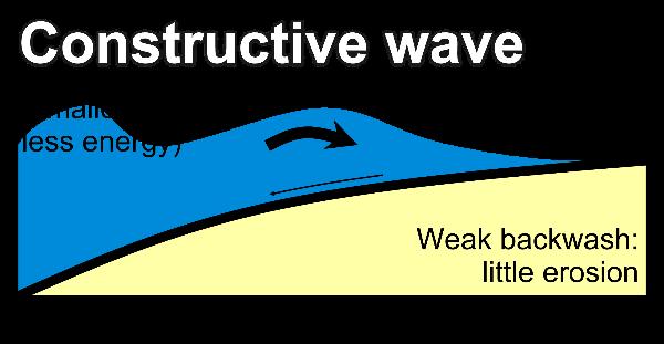
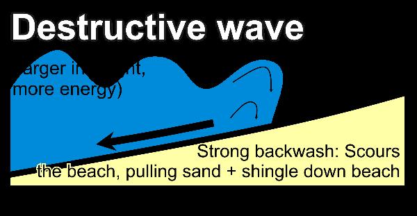
The direction of the swash varies with how the wind is blowing ,
whereas the backwash is always perpendicular to the coastline. This
may cause longshore drift.Backwash current is a seaward current
that results from the receding swash on the beach face, after a
wave breaks, joins the seaward movement of the wave trough toward
the next incoming crest. The same orbital wave movement that causes
a ball to bob up and down on the water causes the trough to move
back and up toward the next wave crest.
Singleton SwashIn 1791 our countries first president traveled
thru the myrtle beach area as part of his journey thru the south.
On april 28th George Washington, his men and a local citizen,
Jeremiah vereen traveled thru what is now known as Singlton
Swash.
Our first president wrote the following in his journel on the
28th. "April 28 Mr. Vareen piloted us across the Swash (which at
high water is impassable, & at times, by the shifting of the
Sands is dangerous) onto the long Beach of the Ocean; and it being
at a proper time of the tide we passed along it with ease and
celerity to the place of quitting it which is estimated at 16
miles."The long bay he refers to is what we now call Myrtle
beach.
In 1778 Ebenezer Hazzard, the united states post master general
at the time wrote the following... "The Swash is a creek which runs
up from the sea, and, it is dangerous, if not impossible to cross
it at high water, but when the tide is out there is not the least
danger. Immediately upon crossing this you enter upon Long Bay..."
"On the left is the open sea from which the surf comes rollin in
with great noise, and often frightens the travellor's horse unless
he is very gentle. On the right is a disagreeable sand bank. The
best time for travelling is about half or three quarters ebb, for
then you have a hard surface to ride upon and may get off the beach
before the tide rised so as to incommode you." So as you have read
a small part of the history the swash was important to the
forefather of our country as well as the development of Myrtle
Beach.
This earthcache brings you to the eastern edge of the
Singleton swash. From here you can see a large part of the swash
and imagine Jeremiah Vereen leading George Washington and his men
across here.
To claim credit please do the following1.) Take a photo of you
and the GPS in with the swash in the background. 2) is this a
uprush and backwash swash.3.) At the time you are could you or
could you not cross the swash?