Grosser Kalkbruch
(Naturdenkmal - liegende Kalkfalte)
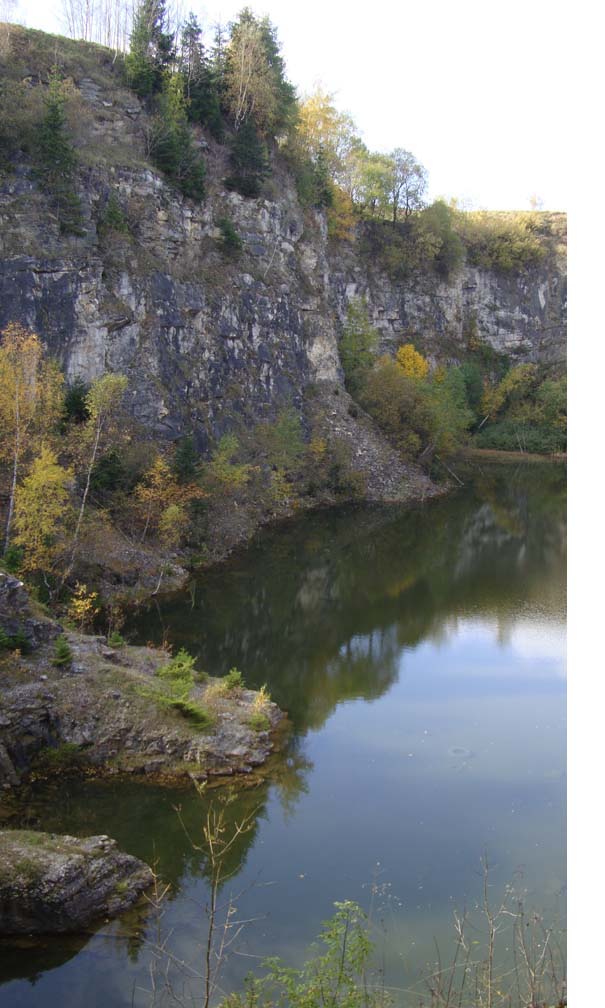
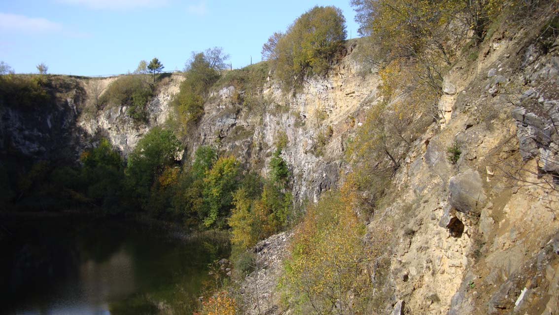
Nordwestlich von Hammerunterwiesenthal befindet sich ein Kalkbruch, auf dem mindestens seit Anfang des 19. Jahrhunderts Kalk gebrochen wurde und der heute wegen der dort vorherrschenden Vegetation unter Naturschutz steht.
Der Aufschluß gilt als eines der interessantesten geologischen Naturdenkmale Europas und ist geschützt. Koßmat (ein sächsischer Geologe) wies 1915 nach, daß der Kalkstein und die ihn umgebenden kristallinen Gesteine unter hohen Temperaturen und Drücken gefaltet und metamorphosiert wurden.
Die Metamorphose hat ursprüngliche Gesteine stark verändert. Der Kalkstein von Hammerunterwiesenthal ist kristallin, also sehr dicht, fest und stellenweise von Glimmer durchsetzt. Kalkstein von Hammerunterwiesenthal ist chemisch zum Beispiel mit dem Kalkstein in Thüringen zu vergleichen. Der Kalk von Hammerunterwiesenthal ist vor etwa 200 Mill. Jahren entstanden.
Nachdem die Kalkplatte durch verschiedene Ereignisse (Einbruch Egergraben, vulkanische Tätigkeiten usw.) auseinander gebrochen und in einzelne Bruchteile abgekippt ist, entstanden Bruch-Schollen im oberen Erzgebirge welche mit 55-60° Einfallen.
Im "EUROPATICKER Umweltruf" war im August 2009 Folgendes zu lesen: Das Alleinstellungsmerkmal für diesen Naturraum sind die höchstgelegenen Kalkvorkommen in Sachsen, die mit den entsprechenden Lebensräumen eine einmalige Tier- und Pflanzenwelt entstehen ließen. Europaweit bedeutsame Lebensräume wie Basophile Pionierrasen, Berg-Mähwiesen, Silikatschutthalden, Kalkhaltige Schutthalden, Kalkfelsen mit Felsspaltenvegetation und Silikatfelsen mit Felsspaltenvegetation. Vorkommen wie den Bitteren Enzian an seinem einzigen sächsischen Fundort, die Schwarzschopf-Segge, die Mondraute, das Katzenpfötchen, eine ganze Reihe von seltenen oftmals in Sachsen nur hier vorkommenden Moosen und Flechten.
Vergleichbaren Kalkstein findet man an der Ostseeküste Rügen.
Bitte keine Absperrung überschreiten. Es besteht Lebensgefahr!
Parkplatz:
N 50° 27.065
E 13° 00.405
Infotafel:
N 50° 27.081
E 13° 00.380
Aussichtspunkt:
N 50° 27.096
E 13° 00.337
1. Welche kristallinen Gesteine umgeben hier den Kalkstein? (Infotafel)
x= 1. Buchstabe
2. Welches waren die ursprünglichen Gesteine, die die Metamorphose stark verändert hat?
y= 1. Buchstabe 1. Gestein
z= 1. Buchstabe 2. Gestein
Bitte sende eine Mail an:
xyz_earth@web.de
Betreff: Kalkbruch
Dann erhaltet Ihr die Logaufgabe und einen TB Code zum Loggen.
Alternativ könnt ihr eine Mail mit den Antworten und GCCode+Cachername im Header senden und bekommt natürlich keinen TB-Code.

Large quarry (natural monument - located calciumhade)
Northwest of Hammerunterwiesenthal there is a quarry, on which at least since the beginning of the 19th Century limestone was quarried and today is there because of the prevailing vegetation protected.
The disruption is one of the most interesting geological natural monuments of Europe and is protected. Kossmat (a Saxon geologist), 1915, after showed that the limestone and the surrounding crystalline rocks under high temperatures and have been metamorphosed and folded Press. The metamorphosis has changed the original rocks. The limestone of Hammerunterwiesenthal is crystalline, that is very dense, solid and occasionally interspersed with mica. Limestone is chemically Hammerunterwiesenthal compare for example with the limestone in Thuringia. The lime from Hammerunterwiesenthal has created about 200 million years ago.
After the calcareous plates of different events ( rift Egergraben, volcanic activities, etc.) apart and broken into individual fraction is tipped, Bruch globules formed in the upper Erzgebirge with the dip 55-60 °.
In "EUROPA TICKER Umweltruf" was in August 2009, to read: The unique selling point for this natural area is the highest concentration of limestone in Saxony, with the appropriate habitat could create a unique fauna and flora. Europe-important habitats such as basophils Sedion, mountain hay meadows, siliceous scree, scree slopes, calcareous, limestone and silicate rocks with chasmophytic vegetation with chasmophytic vegetation. Occurrences such as the Gentian bitter at his Saxon single habitat, the black-crested sedge, the moon, diamond, cat's that, a whole series of often rare in Saxony, only occurring here mosses and lichens.
Please do not exceed the fence. It can be fatal!
Parking:
N 50 ° 27,065
E 13 ° 00,405
Information board:
N 50 ° 27,081
E 13 ° 00,380
Viewpoint:
N 50 ° 27,096
E 13 ° 00,337
1. What are the crystalline rocks around here the limestone? (Info board)
x= 1. letter
2. What were the original rock, which has greatly changed the metamorphosis?
y= 1. letter of the first stone
z= 1. letter of the second stone
Please send a mail to:
xyz_earth@web.de
Subject: quarry
Then you receive the Log mission.
Mit der Logfreigabe gibt es einen Coincode zum Discovern als kleines Goody.