
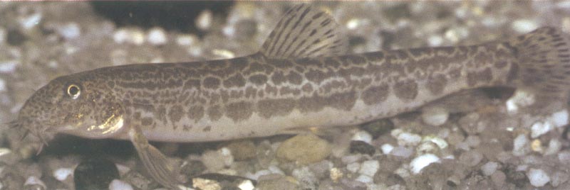
Cobitis
paludica é o nome científico da Verdemã. É uma espécie
piscícola de águas doces, residente e que raramente ultrapassa os
15 cm de comprimento total.
Estatuto de
Conservação (IUCN)
VULNERÁVEL
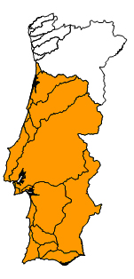
Distribuição
A espécie é endémica da Península Ibérica. Em Portugal, encontra-se
distribuída nas bacias hidrográficas do centro e sul: Algarve,
Arade, Sudoeste, Mira, Guadiana, Sado, Tejo, Oeste, Lis, Mondego e
Vouga.
Ecologia
Vive nos troços médios e finais dos rios, em habitats de baixa
profundidade e velocidade de corrente, estando sobretudo associada
a substratos finos (areia e gravilha) com vegetação aquática. Os
adultos alimentam-se sobretudo de larvas de insectos, outros
invertebrados, algas e detritos. O período de desova tem início em
Maio, podendo prolongar-se até Julho.
Factores de
Ameaça
A introdução de espécies exóticas constitui um dos principais
impactos negativos na sobrevivência desta espécie, uma vez que a
sua capacidade natatória é muito limitada. A destruição do habitat
através da extracção de inertes e a captação da água para a
agricultura têm reduzido o efectivo das suas populações, outrora
abundantes. Outros factores como o poluição e a construção de
barragens, têm contribuído para o declínio desta espécie. A captura
e uso ilegal da espécie como isco vivo constitui igualmente uma
ameaça crescente.
A cache
Esta cache pretende
dar-lhe a conhecer uma espécie piscícola endémica da Península
Ibérica, frequente em muitos rios do centro e sul de Portugal, mas
cujas populações têm vindo a regredir em consequência da contínua
degradação dos ecossistemas fluviais.
A cache encontra-se
num troço ribeirinho de um rio da bacia hidrográfica do Tejo, onde
a espécie se encontra presente.
Existem diferentes
percursos até à cache. Referem-se seguidamente três com
características distintas:
Percurso 1 (acesso por Valejas)
Percurso de inclinação
suave. Estacione o carro em N 38º 43.988; W 009º 15.746 e siga ao
longo do caminho de terra até N 38º 43.877; W 009º 15.668. Aqui
desça o pequeno trilho até o rio e caminhe ao longo da margem até à
cache.
Percurso 2
(acesso por Queijas)
Percurso de inclinação
acentuada. Estacione o carro em N 38º 43.496; W 009º 15.717. Daqui
tem uma vista bastante ampla para o vale do rio. Seguidamente
contorne o bairro pelas traseiras e vá até N 38º 43.588; W 009º
15.819. A partir daqui é só apanhar o trilho que desce a montanha,
até à cache.
Percurso 3
(acesso por Quinta da Gandarela)
Atenção: Percurso
condicionado pela afluência de caudal
Percurso longo de inclinação suave e "menos humanizado".
Desenvolve-se na maior parte ao longo das margens do rio,
proporcionando um agradável passeio pela galeria ribeirinha.
Envolve contudo a travessia entre margens, pelo que a sua
realização está condicionada pela afluência de caudal em
determinado momento. Dependendo da afluência deste, poderá
atravessar facilmente o rio sem sequer tocar na água, ou então ter
de usar calçado apropriado como galochas ou botas de pescador. Em
circunstâncias de grande caudal ou cheia, a travessia não é de todo
possível nem deve sequer ser tentada. Opte neste caso por um dos
outros percursos.
Estacione o carro em N
38º 43.462; W 009º 15.396. Vá até N 38º 43.610; W 009º 15.587. Este
é um possível ponto de travessia (existem outros) para a margem
oposta onde se encontra a cache. Perto deste local pode aproveitar
para descobrir outra
espécie existente neste troço de rio. Uma vez na margem oposta,
existe um trilho directo ao longo do rio até à cache.
IMPORTANTE:
Para que possa ter um
contacto mais estreito com esta espécie, foi colocada na cache uma
amostra contendo um exemplar real desta espécie devidamente
conservado. Esta amostra pertence à colecção de referência do
Instituto Superior de Agronomia e como tal NÃO DEVE, em
circunstância alguma, ser retirada da cache. Destina-se somente
a ser apreciada pelos geocachers. Como tal, quando encontrar a
cache, observe, aprecie, fotografe...mas volte a colocar a amostra
no container, ambos na posição vertical, para que esta possa
ser vista pelos próximos geocachers. Obrigado pela
compreensão.

Cobitis
paludica is the scientific name of the Southern Iberian
spined-loach. It is a freshwater resident fish species, often
reaching no more than 15 cm total length.
Conservation status
(IUCN)
VULNERABLE (VU)
Distribution
This species is endemic to the Iberian Peninsula. In Portugal, its
distribution covers the central and southern basins: Algarve,
Arade, Sudoeste, Mira, Guadiana, Sado, Tejo, Oeste, Lis, Mondego e
Vouga.
Ecology
The species lives in the middle-lower parts of rivers with low
current, being mainly restricted to shallow sandy-gravel bottoms
with aquatic vegetation. Adult specimens feed predominantly on
insect larvae, other invertebrates, algae and detritus. Spawning
period starts in May throughout July.
Threats
Introduction of exotic predators have negative effects in the
survival of this species, since its swimming ability is very
restricted. Habitat destruction by gravel extraction and water
diversion due to agriculture has reduced populations formerly
abundant. Alterations of its habitat by pollution, canalization and
dam construction have caused decline of the species, since their
habitat is restricted to shallow waters with vegetation. The
commercial trade of this species as live bait is also a real
threat.
The cache
The goal of this cache
is to introduce you to an Iberian freshwater fish species, for
which populations, once abundant, are now decreasing due to the
widespread degradation of aquatic ecosystems.
The cache is hidden in
a fluvial segment (not in the river itself, but in the
surroundings) in a coastal river of the Tagus catchment, where the
species is currently present.
There are different
trails that lead to the cache. Please find below three trails with
different characteristics:
Trail 1 (access by Valejas)
Gentle slope trail.
Park the car at N 38º 43.988; W 009º 15.746 and follow the trail to
N 38º 43.877; W 009º 15.668. Here, take the small trail down to the
river and walk along the bank towards the cache.
Trail 2
(access by Queijas)
Steep trail. Park the
car at N 38º 43.496; W 009º 15.717. Here you will be offered a wide
view to the river valley. Then, go around the backside of the
neighbourhood to N 38º 43.588; W 009º 15.819. From here there is
trail that climbs down the mountain towards the cache.
Trail 3
(access by Quinta da Gandarela)
Attention: Trail
conditioned to the existing river flow conditions
Long and easy gentle slope trail and "less human disturbed". This
trail goes along the river banks, offering a pleasant walk through
the riparian galleries. However, at some point it is necessary to
cross the river from one bank to the other, and this can only be
done depending one the present flow conditions. You may have the
chance to cross it quite easily without the need of touching the
water, but with increased flow you may have to bring adequate
footwear (common rubber boots or fisherman boots). In cases of
severe flows or floods do not try the river crossing. Instead,
choose one of the other trails.
Park the car at N 38º
43.462; W 009º 15.396. Proceed to N 38º 43.610; W 009º 15.587. This
is a possible crossing point (there are others however) to the
opposite bank where the cache is hidden. Near this point you may
want to discover another
species present at this river segment. Once at the opposite
bank, there is a trail that follows the river towards the
cache.
IMPORTANT:
A sample containing a
real preserved individual of this species has been placed in the
cache, so you can have a closer contact with the species. This
sample belongs to the reference collection of the Higher Institute
of Agronomy and therefore MUST NOT be taken away from the cache
in any circumstance. It is only for viewing purposes. As so,
when you find the cache, observe, appreciate, photograph…but please
place again the sample inside the container, both in vertical
position, so it can be seen by the next geocachers. Thanks for
your comprehension.