The Eastern Continental Divide
.
Located in the state of North
Carolina this cache should be fairly easy to attain, terrain is not
difficult at all. The Eastern Continental Divide We may have heard
the term Continental Divide during school and forgotten exactly
what it is over the years. With Earth Caches we now have the
opportunity to refresh our memory of geological features or maybe
even learn what they are while seeing a real life example. A
continental divide is a line of elevated terrain which forms a
border between two watersheds. It may be easier to think of a
continental divide as being the peak of a ridge line. It is at this
ridge line that we could pour a glass of water off one side of the
ridge and it would end up in one watershed and a glass of water
poured off the other side would end up in a completely different
watershed.
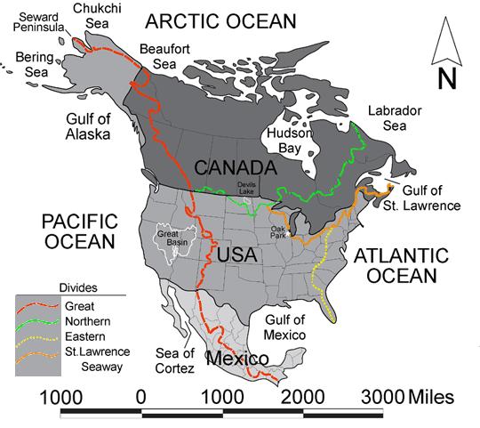
The
United States has 4 Continental Divides:
1) The Great Divide
which is also known as the Continental Divide 2) The Northern
Divide or Laurentian Divide 3) The St. Lawrence Seaway Divide 4)
The Eastern Continental Divide.
How
exactly did these continental divides come to
be?
Over
time with the divides were created by the forming of mountain
ranges through the folding of the earth's crust. This folding
created the peaks or ridges that we know as
divides.
 >
Appalachian Mountain Chain.
>
Appalachian Mountain Chain.
A look at rocks exposed in today's Appalachian mountains reveals
elongated belts of folded and thrust faulted marine sedimentary
rocks, volcanic rocks and slivers of ancient ocean floor, which
provides strong evidence that these rocks were deformed during
plate collision. The birth of the Appalachian ranges, some 300
million years ago, marks the first of several mountain building
plate collisions that culminated in the construction of the
Supercontinent Pangaea with the Appalachians near the center.
Because North America and Africa were connected, the Appalachians
form part of the same mountain chain as the Anti-Atlas in Morocco.
To the northeast, the same mountain chain continues into Scotland,
from the North America/Europe collision.Because the exact border
between bodies of water is usually not clearly defined, the
continental divide is not always definite for any continent (The
International Hydrographic Organization's publication Limits of
Oceans and Seas defines exact boundaries of oceans, but it is not
universally recognized). Moreover, some rivers empty into inland
seas, and thus do not end up in the
oceans
Wrapping it
up.
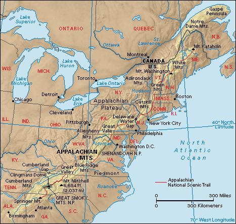
The Eastern Continental Divide runs from a triple
point or triple divide on an unnamed peak near the town of Gold in
northern Pennsylvania near Wellsville (village), New York down the
Appalachian Mountains, through Maryland, West Virginia, Virginia,
North Carolina, and Georgia, and down through the tip of Florida.
The Eastern Divide or Eastern Continental Divide (ECD) is a
continental divide in the United States that separates the Gulf of
Mexico drainage from the watersheds that flow directly into an
ocean.
In order to get credit for visiting this earth cache please do
the following
1.) Take a picture of you and your GPS with Sign behind
you.
2.) What is the elevation at this section of the Eastern
Continental Divide?
3.) If you poured a glass of water to the East, what watershed
would it eventually end up in. If you poured a glass of water to
the West, what watershed would it eventually end up
in?
4.)Identify at least two rocks that you
see.