Nachfolgend die deutsche Beschreibung - the english description is below.
August 2021: Neue Logbedingungen - new log conditions!
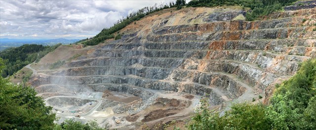
Der Diabas Steinbruch bei Oberhaag
Zur Geologie
Die heute im Lieschengraben abgebauten Gesteine blicken bereits auf eine sehr lange Geschichte zurück: Vor rund 450 Mio. Jahren war das Gebiet des Remschnigg – Poßruck – Höhenzuges vom Meer bedeckt. Aus Spalten und Klüften drang basaltisches (basisches) Magma, welches vom kalten Wasser abgeschreckt wurde, was teilweise noch heute an den Erstarrungsstrukturen erkennbar ist.
Im Zuge verschiedener Gebirgsbildungsphasen – vor allem bei der Auffaltung der Alpen (vor ca. 120 bis 80 Mio. Jahren) wurden diese Gesteine von Süden her über das heute teilweise darunter "Liegende“ Koralmkristallin (ca. 250 Mio. Jahre alt) geschoben: Dabei wurde das Material entsprechend hohem Druck und hoher Temperatur ausgesetzt und zu dem heute begehrtem Wertgestein "Diabas“ umgewandelt, welches sich durch hohe Festigkeit, Elastizität und ausgezeichnete Polierresistenz auszeichnet, und somit seine bevorzugte Anwendung als Baustoff (Asphaltzuschlagsstoff) im hochrangigem Straßenbau findet.
Über den Steinbruch
Der Steinbruch im Lieschengraben erstreckt sich derzeit über eine offene Tagbaufläche von mehreren Hektar. Die mehrere Meter hohe Bruchwand ist in 7 Etagen gegliedert, damit das Material entsprechend den verschiedenen Qualitätsanforderungen selektiv gewonnen und der Abbau trotz der schwierigen tektonischen Verhältnisse sicher geführt werden kann.
Der erste Schritt der Abbautätigkeit ist die Sprengarbeit: Zunächst werden mit einem raupenmobilen Bohrgerät Kopf- und Sohllöcher mit einem Durchmesser von 90 mm hergestellt. Bei der anschließenden Ladearbeit werden diese mit hochbrisantem Sprengstoff gefüllt und mit elektrischen Zündern zu einer Sprenganlage verbunden. Die einzelnen Bohrlöcher werden dabei zur Geringhaltung der Erschütterungen mit einer Zeitverzögerung von wenigen Millisekunden gezündet. Bei einer einzelnen Sprengung werden bis zu 2500 kg Sprengstoff gezündet und damit etwa 7200 m3 Gestein aus dem Gebirge gelöst. Anschließend wird das "Hauwerk“ mit Tieflöffelbaggern geladen und mit Schwerlastkraftwagen zu den Brechanlagen gefördert.
Durch mehrere Brechvorgänge mit Backen- bzw. Kegelbrechern und zwischen- bzw. nachgeschalteter Klassierung (Siebung nach der Korngröße) können die gewünschten Produkte wie Frostkoffer, Riesel, Edelsplitte sowie Urgesteinsmehl erzeugt werden. Große Steine werden getrennt geladen. Sie finden im Wasserbau und bei Hangverbauungen Verwendung.
Als abbaubegleitende Maßnahme muss das überlagernde, nur untergeordnet verwendbare Gestein – zumeist handelt es sich um Tuffite, also vulkanische Aschen – abgeräumt und zu entsprechenden Halden verbracht werden.
Sowohl die schon fertig abgebauten Teilflächen als auch die fertiggestellten Haldenbereiche werden laufend – zumeist als Wald – rekultiviert, so dass die "Wunde“ in der Natur sich im Lauf der Jahre zwar über die Lagerstätte hinwegschiebt, in Ihrer Gesamtabmessung aber nicht größer wird.
Bedingungen zum Loggen des Caches
Um diesen Cache zu loggen, müsst ihr zwei Stationen besuchen und einige Fragen beantworten:
Station 1 - die Schaukanzel:
Auf dem Weg zur Station 2 kommt ihr direkt am Eingang zum Steinbruch vorbei, lasst euch davon nicht irritieren und fahrt weiter den Berg hinauf, bis ihr zum Parkplatz mit einem Hinweis auf den hier geführten Geo-Wanderweg kommt. Lasst an dieser Stelle euer Cachemobil stehen und geht die letzten Meter zu Fuß zur Schaukanzel, von der ihr von oben in den Steinbruch blicken könnt.
Im Häuschen neben der Schaukanzel findet ihr zwei Informationstafeln zum Geo-Wanderweg und zum Diabas-Steinbruch Lieschengraben. Sucht hier nach den Antworten auf folgende Fragen:
1) Wie groß ist die Tagbaufläche des Steinbruchs? Antwort: a ha
2) Wie hoch ist seine Bruchwand? Antwort: b m
Bitte notiert euch die genauen Angaben!
Station 2 - der Diabas:
Etwas oberhalb der Schaukanzel findet ihr einen Diabas, der zum Geo-Wanderweg der Region gehört. Auf diesem Stein ist eine durchsichtige Platte befestigt, auf der ihr weitere Informationen über das Gestein, das in diesem Steinbruch abgebaut wird, findet.
3) Notiert euch das Alter des Diabas in c Millionen Jahren (die niedrigere Zahl, die auf der Tafel in Klammern steht).
4) Seht euch den Diabas an. Was fällt euch auf? Wie würdet ihr ihn bezüglich Größe und Aussehen beschreiben?
5) Macht bitte ein Foto von euch oder eurem GPS vor Ort, das ihr an euer Found-Log anhängt. Ob ihr das lieber auf der Schaukanzel oder beim Diabas tut, ist euch überlassen.
Schickt die Antworten auf die Fragen entweder per Mail oder über das Nachrichten-Center, danach dürft ihr loggen.
Found-Logs ohne Foto oder ohne gesendete Antworten werden gelöscht!
Optional
In der Volksschule von Oberhaag befindet sich eine Mineralienausstellung, die Funde aus dem Steinbruch und der Region zeigt. Es lohnt sich, diese kleine, aber sehr liebevoll gemachte Ausstellung kennenzulernen! Besuche sind mit Voranmeldung bei Josef Kolar möglich (Die Kontaktdaten findet ihr zB hier).
Happy Caching!
The Diabas Quarry at Oberhaag
About geology
The rocks that are mined in Lieschengraben do have a very long history: About 450 million years ago the mountain range of Remschnigg-Poßruck was covered by an ocean. Magma ascended through rifts and fissures and came in contact with the cold sea water - the material solidified. Traces of this process can still be seen today in the structure of the rocks.
During the different phases of orogenesis - especially the alpine orogenesis (about 120 to 80 million years ago) - these rocks were laterally moved from south over the underlying "Koralmkristallin" (age of 250 million years): Because of this the material was exposed to high pressure and temperature that lead to the transformation to Diabas. Diabas is valuable for the industry because of its high persistency, flexibility and polishing resistency. Therefore it is nowadays very often used as construction material for asphalt in roadmaking.
About the quarry
The quarry in Lieschengraben has a size in surface mining of about a ha. The quarry's height is about b m and it is divided in seven levels. This was done to ensure that the material can be gained according to the different quality claims and that the mining can take place on a secure basis despite the difficult tectonic situation.
The first step in mining is the blasting: At the beginning boreholes with a diameter of 90 mm are put into the material. Afterwards these holes are filled with explosives and connected to electrical fuzes. To keep the ground motion on a low level the different holes are ignited with a short time delay. A single blasting needs about 2500 kg of explosives and dismantles about 7200 m3 of rock material. Afterwards the loose material is loaded onto trucks and brought to several facilities where the material is broken and crushed to lower size and stone dust. Large rocks are seperately loaded and used in underwater building and slope-stabilizing.
Additionally the overlying material - mostly volcanic ashes (Tuffites) - must be removed and brought to according stockpiles.
Throughout the time the quarry keeps its size because areas that are no longer used for mining are revegetated as forest. Therefore the "wound" moves through the years over the mining area but doesn't get larger.
Conditions for logging this Cache
If you want to log this cache you need to visit two stages and answer a few questions:
Stage 1 - the viewpoint:
When going to stage 1 you will pass the entry to the quarry. Don't be irritated and follow the road up the mountain until you reach a little parking area with a rock and plate about "Geo-Wanderweg" in German and Slovenian. Leave your car there and walk by foot the last few meters until you reach the viewpoint where you can have a wonderful look onto the quarry.
Next to the viewpoint there is a small hut with two information signs about the quarry and the geological hiking trail of the region. Search here for the missing information in the description of the quarry.
1) What is the size of the quarry? a ha
2) What is the height in meters? b m
Please write down the exact numbers!
Stage 2 - the Diabas:
A little bit above the viewpoint you find a single rock - a Diabas which belongs to the geological hiking trail of the region. On this rock a transparent plate gives you further information about Diabas.
3) Please tell me the age of the Diabas in c million years (As there are two numbers written in brackets - please take the lower one!).
4) Have a look at the stone. How would you describe it concerning surface, color and height?
5) Please take a picture of you or your GPS at the location that you attach to your found-log. It's up to you if you want to take it at stage 1 or stage 2.
Please send the answers to the questions per mail or via message center of Geocaching.com, then you are free to write your log message.
Found-logs without log pictures or without answers sent will be deleted!
Optional
In the primary school of the village you will find a mineralogic exhibition with discoveries of the quarry and the region. If you want to visit this small, but very nice exhibition please contact Josef Kolar and make an arrangement for a visit (Contact information can be found e.g here).
Happy Caching!