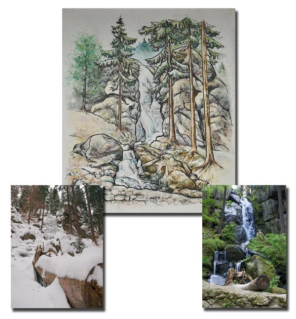
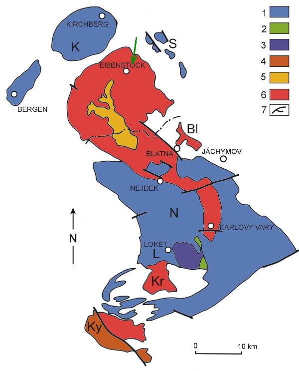

We can find this very interesting place 15 km South-West from city of Aue and 3 km North-East from Eibenstock. Waterfall in Blauenthal is man-made, but it doesn´t sink its beauty. Geologically, this place lies within the Ore Mountauins. In these places, bedrock is formed by (question nr. 2), whitch is compounds of flint, orthose, plagioclase, black mica and amphibole. This rock is very resistnant to climatic influences and it is typically rosy-coloured. In nearby Eibenstock, it is mined for decorative and constructive purposes. This rock occurrence in Ore Mountains can be seen in enclosed map (every colour means the same rock, only with a little different structure). History of this place dates back to 16th century. In the year 1530 Andreas Blau, manufacturer and tradesman from Nurmberg, has bought place of former mill and saw-mill and he has build here a new important hammer-mill. As time goes on, quantity of water has came short of industrial needs. So factory owner and comercial counsellor Toelle has built bricked mill race, after the First World War. The mill race was built above scaur in the Bockau Valley, so the water could drive turbines of Toelle´s papermill. This mill race run from Malá Bockau v Pekelném údolí, flow through Velká Bockau and after 3 km it get close to papermill. Papermill didn´t work in Sundays and holiday, so the water in mill race was redirected through granit scaur and it created very impressive „natural“ scenery. Production in papermill was terminated and since the time is waterfall known as tourist attraction. In winter we can find here monumental ice-fall and courageous sportsmen can try to ice-climbing here.
And here are my educational questions:
To log this Earthcache, take a photo of yourself with GPS (fotohint) and send me the answers to the following questions in an email (not in the log) in my profil with subject "Waterfall":
1. measure how high is the waterfall
2. how call the rock in the underbed of waterfall
3. how call the geologic group (eruptive, sediment or metamorphosed rock) of this rock

Diesen interessanten Ort finden wir 15 km SW von Aue und ca. 3 km NÖ von Eibenstock. Auch wenn der Wasserfall eigentlich Künstlich gebildet wurde, nimmt ihm das nichts von seiner Schönheit. Geologisch gesehen gehört die Gegend zum Erzgebirge und die Bodenschicht besteht an diesen Orten aus Gestein (Frage 2), das aus diesen Mineralien zusammengesetzt ist – Quarz, Ortoklas, Plagioklas, Biotit und Amphibol und außerordentlich wetterbeständig ist. Das Gestein ist an diesen Orten typisch rosarot und wird im nahen Ort Eibenstock zu Bau – und dekorativen Zwecken abgebaut. Das Vorkommen dieses Gesteins im Erzgebirgsbereich ist auf der Karte zu sehen (jede Farbe bedeutet dasselbe Gestein, nur mit einer anderen Zusammensetzung). Um 1530 erwarb der aus der Gegend von Nürnberg stammende Blechhändler und -produzent Andreas Blau (Andres Blaw) den Standort einer ehemaligen Mahl- und Brettmühle und baute ihn zu einem bedeutenden Hammerwerk aus. Nach dem Ersten Weltkrieg ließ der Fabrikbesitzer, Kommerzienrat Toelle, einen neuen aus Naturstein gemauerten Betriebsgraben oberhalb einer steilen Felswand im Tal der Bockau anlegen, um mit dem Wasser die Turbinen seiner Papierfabrik anzutreiben. Dieser Kunstgraben zweigte bereits von der Kleinen Bockau im Höllengrund ab, verlief über die Große Bockau hinweg, um nach etwa 3 km die Papierfabrik zu erreichen. An Sonn- und Feiertagen, wenn die Maschinen still standen, wurde das Wasser über eine imposante Felswand aus Granitblöcken umgeleitet und stürzte von d a ins Tal. Seit Einstellung des Betriebs besteht der Wasserfall nunmehr dauerhaft und hat sich zu einer Touristenattraktion entwickelt. Im Winter kann man bei genügend Eis den seltenen Sport des Eiskletterns ausüben.
Nun zur Bildungs-Aufgabe des Earthcaches:
Um diesen Earthcache loggen zu dürfen, mache bitte ein Foto von Dir (Fotohint) und beantworte mir folgenden Fragen in einer Email (nicht im Log) durch mein Profile mit dem Betreff "Waterfall" nicht auf die Freigabe warten, falls die Antworten nicht richtig sind, melde ich mich:
1. wie hoch ist der Wasserfall
2. aus welchem Gestein besteht der Waserfalluntergrund
3. welcher geologischen Gruppe gehört (Eruptiv-, Sediment- oder Metamorphes Gestein) dieses Gestein

Toto zajímavé místo najdeme 15km JZ od mesta Aue a cca 3km SV od mestecka Eibenstock. Ac byl ve skutecnosti vodopád vlastne vytvoren umele, nic to neubírá na jeho kráse. Geologicky spadá oblast do Krušných hor a v techto místech je podloží tvoreno horninou (otázka c.2), která je složena z minerálu – kremen, ortoklas, plagioklas, biotit a amfibol a je velmi odolná vuci povetrnostním vlivum. V techto místech má typickou naružovelou barvu a v nedalekém mestecku Eibenstock se teží pro stavební a dekorativní úcely. Výskyt této horniny v oblasti Krušných hor je videt na mape (každá barva znamená stejnou horninu, jen s trochu jiným složením). Kolem roku 1530 získal výrobce a obchodník s plechem Andreas Blau, který pocházel z okolí Norimberku, sídlo bývalého mlýna a pily a vybudoval zde významný kladivový mlýn. Po první svetové válce nechal majitel továrny, komercní rádce Toelle, zrídit z prírodního kamene vyzdený provozní príkop nad strmou skalní stenou v údolí Bockau, aby mohl vodou pohánet turbíny své papírny. Tento umelý príkop odbocoval již od Malé Bockau v Pekelném údolí, tekl pres Velkou Bockau dál a dostal se po cca 3 km k papírne. V nedelích a o svátcích, kdy stroje nepracovaly, byla voda presmerována pres impozantní skalní stenu ze žulového kamene a rítila se odtud do údolí. Od ukoncení výroby vodopád trvale tece a stal se turistickou atrakcí. V zime, pri dostatku ledu, lze provozovat vzácný sport lezení po lede, neb z vodopádu vznikne ledopád.
A nyní k otázkám u této earthcache:
Pro zalogování je nutné porídit fotografii vás a GPS (fotohint) a dále zaslat odpovedi na níže uvedené otázky přes můj profil s predmetem "Waterfall". Není nutné cekat na schválení odpovedí, v prípade nejasností se ozvu:
1. jak je vodopád vysoký
2. název horniny podloží vodopádu
3. do jaké geologické skupiny (vyvrelina, sediment nebo premenená hornina) patrí tato hornina
TB2YYTF TB36HFR TB36J7N TB36HR9 TB36J2A

