
 The
Trona Pinnacles are a short drive south of the paved highway. The
final few miles are unpaved, but easily accessible by all cars in
dry weather. There is a driving tour around the edge of the
northern tufa towers or a short walking path through them. No water
is available and summer temperatures can be extreme. Despite their
appearance, the Tufa are fragile, so please be respectful of the
area. Collection, destruction, or vandalism is prohibited.
The
Trona Pinnacles are a short drive south of the paved highway. The
final few miles are unpaved, but easily accessible by all cars in
dry weather. There is a driving tour around the edge of the
northern tufa towers or a short walking path through them. No water
is available and summer temperatures can be extreme. Despite their
appearance, the Tufa are fragile, so please be respectful of the
area. Collection, destruction, or vandalism is prohibited.
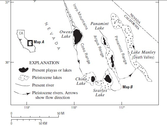 Following each of the recent glacial episodes,
glacial melt water formed a chain of five lakes along the Eastern
Sierra Nevada to Lake Manly (now called Death Valley). This area
was filled by Searles Lake. Following the Tioga glaciation about
20,000 years ago the Searles Lake filled to about the elevation
where you are standing forming the tufas near her. An older
glaciation, the Tahoe glaciation which was about 75,000 years ago
filled Searles Lake to a deeper depth forming the towers further
south.
Following each of the recent glacial episodes,
glacial melt water formed a chain of five lakes along the Eastern
Sierra Nevada to Lake Manly (now called Death Valley). This area
was filled by Searles Lake. Following the Tioga glaciation about
20,000 years ago the Searles Lake filled to about the elevation
where you are standing forming the tufas near her. An older
glaciation, the Tahoe glaciation which was about 75,000 years ago
filled Searles Lake to a deeper depth forming the towers further
south.
The Trona Pinnacles formed along the western shore of Searles
Lake. Each time the chain of lakes formed, evaporation from each
lake in the chain concentrated the salts in the water. By the time
the water reached Searles Lake, the water was a brine. At this
location, fractures in the lake bottom allowed calcium rich
groundwater to seep into the lake forming calcium rich lake water.
Calcium carbonate precipitated from this water as the water
temperature changed, water evaporated from the lake, and carbon
dioxide was removed from the lake water. It was the removal of
carbon dioxide by algae during photosynthesis that was likely the
primary way the tufas formed. Decreasing the carbon dioxide
concentration in water reduces the solubility of calcium carbonate.
Close examination of the tufas reveals an abundance of organic
matter and casts of algae and algae colonies. Over the years,
layers and layers of calcium carbonate were deposited around the
outlet of the groundwater springs forming these towers.
Since algae photosynthesis was the primary mechanism that helped
form the Trona Pinnacles, they must have formed in water less than
100 feet deep since sunlight becomes too week for photosynthesis
below that depth.
These are the same kind of formations found around
Mono Lake.
Logging Requirements
Send me a note with :
- The text "GC26901 Trona Pinnacles" on the first line
- The number (including non-cachers) and names of the geocachers
in your group.
- From the information sign, what are some of the factors that
contributed to the formation of the towers?
- The information sign says that small _____ ______ grow to
become the most spectacular tufa formations in North America. What
are the missing words and describe those items in the tufa
towers.
The following sources were used to generate this
cache:
- Sharp, Robert P. and Allen F. Glazner, Geology
Underfoot in Death Valley and Owens Valley, Mountain Press
Publishing Company, Missoula , Montana, 1997
- Bureau of Land Management Informational
Signs
- Smith, G.I., 2009, Late Cenozoic geology and
lacustrine history of Searles Valley, Inyo and San Bernardino
Counties, California: U.S. Geological Survey Professional Paper
1727, 115 p., 4 plates.
http://pubs.usgs.gov/pp/1727/pp1727_text.pdf