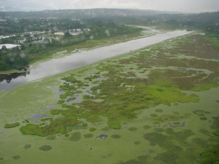
Recent aerial view of Burnaby Lake - City of Burnaby photograph
The posted coordinates take you to the end of Piper Spit. Please email me with your findings in order to show you have learned something here, and that you have visited the spot. Please read the geology and the history below to find out about the past, present and potential future of the lake.
As required for Earthcaches, logs that have not met the requirements will be deleted.
1. Standing at the end of the boardwalk, close your eyes and listen. What do you hear? Listen carefully for all the sounds, both human and natural.
2. Look out above the lake to the southwest. What do you see that may have an impact on the natural evolution of the lake?
3. How have the soft soils in the valley helped to preserve the lake and the surrounding park? Think about the underlying geology of the area, particularly the deep layers of peat, silt and sediments. You will have to think of an answer - it is not available in any of the written materials on site.
4. Can you identify some structures in the lake not made by people that are often associated with slowing water flow helping to create increased siltation?
5. Compare the two photographs on the cache page taken about 70 years apart. Describe the difference.
6. The pilings you see in the middle of the lake are called dolphins and mark the ends of the rowing course. Do you see much open water in this area? Can you estimate the depth of the lake in front of the boardwalk?
7. What is the last name of Cliff and Gladys?
Geology of the Lake
Burnaby Lake is a shallow urban lake, part of the Brunette River watershed which covers an area of 73 square kilometres starting near Renfrew Street in Vancouver where Still Creek originates, to New Westminster where the Brunette River flows into the Fraser River. Most of the water entering the lake comes from either Still Creek or Deer Lake Brook. There are also many smaller streams that flow down from the hillsides on both the north and south sides of the lake. The lake is a result of glacial erosion from receding ice 12,000 years ago during the Pleistocene Era forming the U-shaped Central Valley area of Burnaby.
The geology of the lake bottom is that at the centre of the lake there is a layer of peat that varies from 5 metres to 10 metres in depth. Under that is a layer of silt appx 15 metres thick. Under that is 15 metres or more of dense fluvial sediments and dense glacial till. The surrounding valley has varying levels of peat and silt.
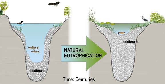
The normal evolution for a lake with this structure is that vegetation will gradually fill it in so that it becomes a marshy meadow with streams running through it. This process is known as eutrophication. In an urban setting however, this process is greatly accelerated with runoff from streets and cleared areas increasing silt in the waterways. Also, fertilizers used on lawns and gardens are washed into the storm sewers and make their way to the lake to fertilize the vegetation there. The normal evolution of Burnaby Lake would take hundreds of years. With human activity this process is estimated to take between 50 and 100 years. If the lake fills in then the surrounding water table will rise. The effect of this will cause flooding problems not only to the trail system but also to the railway and the freeway. The only way to slow this process is to dredge silt from the lake.
"
Human History of the Lake
Archeological evidence suggests that local Tslei-Waututh First Nations set up summer camps at the lake to harvest salmon. On April 25, 1859, Robert Burnaby, private secretary to Colonel Richard Moody, commander of the Royal Engineers took a party of 6 led by a First Nations guide up the Brunette River to Burnaby Lake. As part of the same expedition they followed Still Creek as far as they could on it’s (at that time) winding route until they had to turn back due to the large number of snags. Robert Burnaby named the river Brunette due to its dark brown colour, a result of the peat deposits on the lake bottom (think of the peat acting like a tea bag in water).
In the early 1890s logging camps were built on the shores of the lake with temporary dams built at the eastern outlet to raise the level of the lake so that logs could be floated then sent down the Brunette River to the Fraser River and to mills. In 1904 the Great Northern Railway built tracks on the north side of the lake. This led to the famous (but unconfirmed) story about an entire train engine being swallowed in the peat bog while workers were at lunch.
In the early 1900s flooding was a big problem in the area. This was largely due to deforestation on the surrounding area, leading to rapid flows of runoff with silt entering the lake in large amounts. In 1910 the Vancouver and Districts Joint Sewerage and Drainage Board was formed mostly to deal with flooding in the Brunette Basin.
"
Historical photograph of Burnaby Lake circa 1934?
City of Burnaby photograph
The first permanent dam was built at Cariboo Road in 1915. The lake was dredged in 1935 and Still Creek and Brunette River were both dredged and straightened. The dredging was repeated in the 1950s and again in 1971 to form a world class rowing course for the 1973 Canada Summer Games. The material removed as a result of all these dredging projects was deposited in the shallower sections of the lake instead of being removed.
Current Activities
As a result of the most recent dredging in 1971, the inflow of silt to the lake increased as new silt was deposited and previously dredged materials flowed back into the lake. Worse, due to years of industry and other human activity, the silt in the lake contained heavy metals and other contaminants. Oxygen levels were decreasing, plant life and aquatic creatures were suffering.
The City of Burnaby had ongoing debates starting in the 1980s about what to do about the lake – to dredge or not to dredge? Should council stop the natural evoloution of the lake, slow it, or reverse it? What would be the environmental impact of dredging up contaminated soils? Can dredging be done safely without impacting the delicate ecosystem? How would the dredgeate be handled? How would recreation opportunities be impacted by further reduction of open water in the lake? While they talked, the lake continued to fill in.
In 2000 the City of Burnaby, along with other cities endorsed the Brunette Basin Watershed Plan which has as its goal to “Protect or enhance the integrity of the aquatic and terrestrial ecosystems and the human populations they support in a manner that accommodates growth and development”.
In 2002, the City of Burnaby commissioned several studies to consider the effects of dredging the lake from different perspectives. These technical reports and other background are available online here. Finally, in the spring of 2010, dredging has started with the staging area located in the parking lot at the sports fields.
Other Things to do at Burnaby Lake
- take a hike around the lake – bring a picnic or some snacks for the 11 km trek. Visit other caches along the way. Take your time, enjoy this special place.
- Visit the Nature House – open from Victoria Day weekend till Labour Day weekend. Be sure to visit the sun dial outside. Can you think why there are some hours missing?
- Download Podwalks – free iTunes downloads from Metro Vancouver Parks and follow the tours here
- Feed the birds. Please don’t feed them bread, it is bad for them. Bring some good quality birdseed. I remember seeing my 2 year old son eye to eye with a Canada Goose here many years ago
- When you go for a walk, count the number of dogs you see. Does anyone NOT have a dog?
- Visit Cariboo Dam. Would you believe that there is an elevator to bring the fish up to the lake from the Brunette River?
- Just across the dam a little ways is the Burnaby Equestrian Centre. There is an outdoor riding ring where you may be able to see riders taking horses through their paces.
- Visit the Rowing Pavilion. You may be able to see people getting into some very tippy boats.
- When you cross Deer Lake Brook look upstream. I have often seen 3 Painted Turtles (an endangered species) sunning themselves on the log that is sticking out of the creek.
- At the northwest corner of the sports field is an area reserved for RC model aircraft. If you are there on a nice day with no wind you may see a private airshow.
- Visit the Wildlife Garden at Burnaby Wildlife Rescue Centre. The centre is not open for public tours but the gardens are open to visitors.
I hope you have enjoyed your trip to Burnaby Lake. Keep coming back for more!
Sources Used:
City of Burnaby Burnaby Lake Rejuvenation Project Website www.burnabylakerejuvenation.ca
Environmental Assesment Report - Fish Assessment, Ken Lamberton & Alex Sartori, Jan, 2002
Environmental Assesment Report - Engineering Report Associated Engineering, Jan 2002 (inlcuding Appended Geotechnical Study, Golder & Associates Ltd, May 2001)
LM
