Walking On Water
The Quoile River begins its life as the Ballynahinch River which
flows from west of the town of Ballynahinch to Annacloy where it is
known as the Annacloy River. This then becomes the Quoile proper,
which flows through Downpatrick and the Quoile Pondage before
finally emptying into Strangford Lough.
It’s hard to believe, but this whole area used to be an
estuary filled with sea water from Strangford Lough at each hide
tide. The remains of Quoile Quay, Steamboat Quay and the old ship
“Hilda” remind us that until the 1940’s this was
a busy port, with sailing ships and steamers carrying timber, coal
and slates down to Downpatrick. The town was subject to regular
flooding and so in 1957 a new tidal barrier was built downstream.
This created a dramatic change from sea water to fresh water, and
began the natural development from the former seashore to the
river, marsh, grassland and woodland we see today. Today the
riverside path follows the Quoile River for nearly 1.5 miles from
the Old Floodgates at the Downpatrick end of the reserve, to
Steamboat Quay.
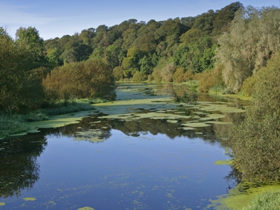
The Pondage is now rich in plants, fish and birds. The combination
of river and woodland is ideal for otters, but the Quoile is better
known for the wildfowl – ducks, geese and swans. Up to 2000
birds spend the winter here; many stay and breed in summer. The
Quoile Countryside Centre, next to the Quoile Castle, is a good
starting place for exploring the reserve. There is a small
exhibition, and information is available about the area.
This cache is a small tab lock box with the usual swaps, log book
and pencil. As this
is a area which can be quite busy at times please ensure that you
are very discrete in retrieving and replacing the
cache. Also please put it back exactly where you
got it from.
Parking for this cache can be in two places. The main car park at
the start of the river walk N54° 20.625 W005° 42.217 if you would
prefer a longer walk or N54° 21.338 W005° 41.627 if you would
prefer a shorter walk.