The following questions are asked to log the cache (note be careful because this area is narrow). Go to the coords and look North.
1-If you look up when looking North you can see a channel running down the cliff. What is the difference in the makeup in the material layers" Do you see any?
2-Observe the smaller rocks that is laying about. How is it made up? Shapes?
3-Are there veins or cracks in the wall? Describe them.
4-Does this wall lean? and if so what direction?
At waypoint Stage 1 on the way back to parking look south at another wall.
5-Does this lean differently? and why do you think so?
Also please follow your log with an email to me with the answers. I feel bad deleting logs but It is part of the game of Earthcaches. Make sure you do not give away the answers in your logs or I will have to delete those as well.
250 to 300 million years ago there was a massive ocean during a period referred to as a Permian era. The silt and dead marine life filtered down to the base of the ocean. Different erosion from the land and made variations in the layers.
Eventually that silt and marine life is pressed into layers. The pressure and movement of the earth pressed it up and not those layers turn to be nearly vertical
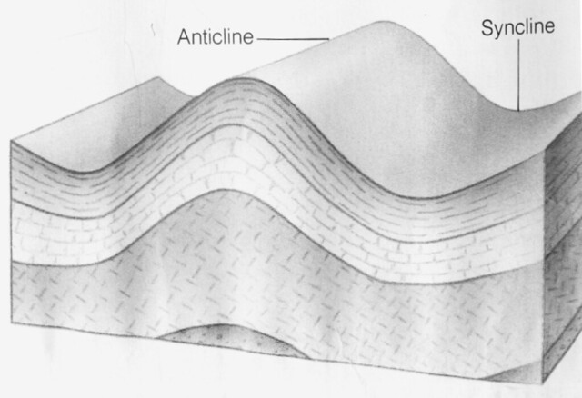
Most of the time these "flexes" in the earth are minor or lead to a bend in the earth up to 45-50 degrees. Rarely these are bent into a nearly vertical angle.
Erosion kicks in. The softer layers of sandstone fade away and now we have what appears to be a large vertical wall. The name that it is known by geologists is that these are from the Park City Formation and the stone is a limestone and a siltstone
