Prior to July, 1993, the area below the flood spillway was a
gently sloping, grassy recreational area used for dirt bikes.
Erosion was initiated in early July when some water was released
(10,000 to 25,000 cfs) through the gates just to keep the rising
flood waters from running uncontrolled over the top of the
spillway. However, the water level in the reservoir continued to
rise, and all 18 floodgates were opened, greatly accelerating the
erosion processes. In fact, this was the first time since the dam
project was completed in 1962 that the gates were opened. When the
gates were closed later, it was discovered that the landscape of
the spillway channel had been transformed into a craggy,
variegated, and multilayered canyon. Geologists and laymen have
been presented with a unique opportunity to have a horizontal view
of thousands of square meters of strata that usually are observable
primarily in vertical sections (e.g., roadcuts, hillsides,
etc.).
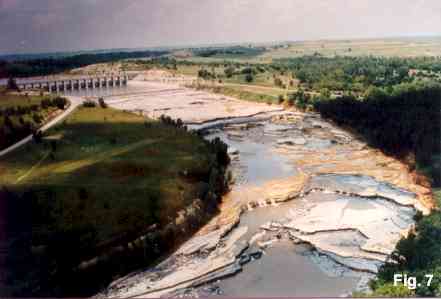
In the spring of 1993 intense rains raised the level of Tuttle
Creek Lake 61 feet above normal pool and started to overflow the
spillway gates. Up to 60,00 cfs was released at the height of the
flood. The water travel down tothe Kansas river with 380,00 cubic
yards of material eroded from the spillway channel. "... it was
turbulent, rolling, rocking, and cutting as it moved, carrying tons
of sediment that acted like a chisel, a drill, a grinder, and a
thousand bulldozers, all in one. The resulting mass of water hit
the loose and poorly consolidated sediment and rocks below the
spillway lip like a massive explosion — lifting, cutting, and
churning its way ... carrying along hundreds of tons of boulders,
gravel, sands, shale, and limestone which it had just torn loose as
it roared over the rock surface." (Archer et al., 1993) The roar of
the water could be heard from half a mile away.

The strata exposed below the spillway have been identified as
Paleozoic, representing late Pennsylvanian through early Permian
systems which, in evolutionary time, are thought to be about 290
million years old. The concrete spillway rests upon the Neva
Limestone and the underlying Salem Point Shale. A variety of both
invertebrate body and trace fossils may be found in the newly
exposed strata (Archer et al., 1993).
The Means of Erosion
The rock strata below the spillway at Tuttle Creek is marked by
joints (fractures) which represent structural weaknesses (Archer et
al., 1993; Anon., 1993). Such joints, which are roughly parallel
and may extend through strata for long distances horizontally and
vertically, likely contributed to the rocks being ripped away by
the fast moving water. The erosive action was doubtlessly aided by
the velocity of the water and its sediment load which consisted of
abrasive matter such as sand, gravel, boulders, etc. Physical
processes associated with macroturbulent flow, which contribute to
erosion of bedrock during catastrophic flooding, have been
elucidated by Austin (1991b; p. 88). These include:
1. Cavitation — a rock pulverizing process resulting from
the implosion or collapse of vacuum bubbles (see also Holroyd,
1990a and 1990b)
2. Plucking, or the hydraulic lifting of large blocks of bedrock
— a suction process which results from the vortex action of a
"kolk"
Could such processes have been active in these cases of rapid
canyon formation? Hydraulic plucking obviously occurred, since
large blocks of bedrock were scattered haphazardly downstream at
Manhattan.
That cavitation may have taken place is not as evident. Holroyd
(1990a, p. 24) instanced data from the Bureau of Reclamation
indicating that cavitation may occur at fluid flow speeds greater
than 30 meters per second (67 mph). Austin (1991b, p. 88) cited
NASA data which suggest that cavitation may be associated with
fluid flows as slow as 30 ft per second (20 mph). It was in fact
earlier noted that water moved down the Manhattan spillway at
60,000 cfs suggesting that conditions conducive to cavitation could
have existed during the canyon's formation. It is also possible
that continued pulverizing and weakening of the rock and subsequent
erosive action could obliterate any direct physical evidence of
cavitation.
References
Archer, A.W., J. Kinser, S.C. Grant, J.R. Underwood, P.C. Twiss,
R.R. West, K.B. Miller. 1993. Geology of the recently formed Grand
Canyon of Manhattan. Department of Geology, Kansas State
University, Manhattan.
____. 1993. A visitor's guide to geologic features at the
Coralville Lake emergency spillway. Geological Survey Bureau, Iowa
Department of Natural Resources, Iowa City.
___. 1991b. How was the Grand Canyon eroded? In: Grand Canyon
— Monument to Catastrophe (prepublication copy), S.A. Austin,
editor. Institute for Creation Research, Santee, CA, pp. 69-91.
Holroyd, III, E.W. 1987. Missing talus. CRSQ 24:15-16.
___. 1990a. An introduction to the possible role of cavitation
in the erosion of water channels. CRSQ 27:23-32.
___. 1990b. Some simulations of the possible role of cavitation
in catastrophic floods. CRSQ 27:49-55.
To get credit for this earthcache email me the answers to the
following questions:
1. On what date does the information board say they closed the
spillway gates.
2. How many pictures are there on the information board?
3. Use your GPS to figure out what direction you are facing
while reading the information board.
4. Tell me what the elevation is at the information board.
5. You can also post a picture.
Thanks for visiting my earthcache.