This is a easy park n grab cache, I really wanted a stop between Montoya's and Mancos Hill but the rail bed is all in the San Juan National Forest, so go out and enjoy your ride Chasing the Rails. There is a lot of neat old rail bed..if you want to chase the rails you have some driving to do.
There are two ways to get to this cache. The fast and easy way from the top of Mancos Hill, the other is from Cherry Creek Forest Access RD.
If you come in from Cherry Creek RD, you will need high clearance, 4x4 is a good idea, but would be nice. You will travel some 5 plus miles of old rail bed once you get up to it and then you will end up at the cache at the top of Mancos Hill after Chasing the Rails. It is a very nice ride, beautiful views, a 2 wheel drive high clearance will get you there, did me, use CAUTION!!!
If you grab this cache off 160 at the top of Mancos Hill it is a park and grab and then you can drive up 316 to 508 and make a right, then follow the old rail bed back to Starvation Creek Drainage. You can drive a low car for a long ways down the old bed on 508, there are some deep cuts across the road from run off, use caution.. Also after you make the right onto 508 and go about 1/2 miles you are in the area of the old town of Grady
If you do go Chasing the Rails at this cache from either direction, here are some points of interest. Listed coming from 316 and going back to Starvation Creek. Location of Benchmark HM0054, Cub Scout Pack 533 Cache, Rail Timbers Near Benchmark HM0053, and Starvation Creek Trestle Overlook. I have not made it to Benchmark HM0051 or the East Mancos Water Tower, yet, need 4x4 to go there.
Couple of images from our journey Chasing the Rails to place this cache.


Some YouTube Clips I Found.. From the Cab of the Gallaping Goose and the Galloping Goose Running the Track Near Durango, Co
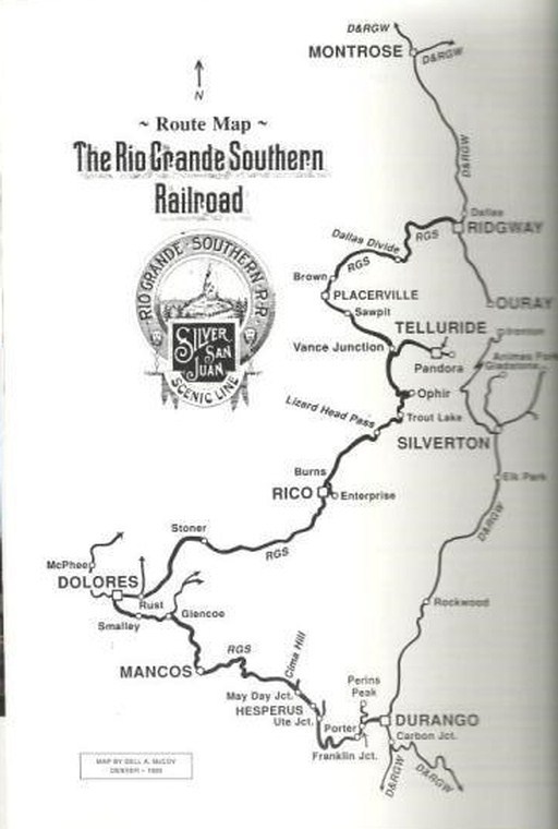
The Rio Grande Southern was one of the most spectacular narrow gauge railroads in the world. It provided heavy transportation service for the west side of the San Juan mountains and traveled through spectacular scenery that, prior to the railroad, was only accessible by the most determined traveler using horses, wagons, or even basic foot power.
The Rio Grande Southern Railroad (RGS) ran from Durango to Ridgway in the western part of the US state of Colorado. Its right of way can be traced by going west from Durango to Mancos, then to Dolores, north across Lizard Head Pass (10,222') to Placerville, with the final leg to Ridgway.
The route passed over Dallas Divide west of Ridgway and over Lizard Head Pass north of Rico. The most famous structure on the route was the Ophir Loop near Ophir. At this point the railroad was built up a narrow mountain valley and looped back up the other side to gain elevation over several tall trestles.
The RGS filed with the Interstate Commerce Commission for abandonment on 24 April 1952.
Details for Benchmark between Montoya's and Mancos Hill location:
Benchmark HM0051 Benchmark HM0053 Benchmark HM0054
Next Stop, Echo Basin.... ALL Aboarrrrrrd!!!!!
or Montoya's.. ALL Aboarrrrrrd!!!!!.....
Be sure and check out the WILDCAT RGS VIEW and A Funny Way to Ride the Rails #2 while chasing the rails.
Well Br_Eyez hit the ground running on this one, the ink was still wet on the publish. Good Job!!!