Uluru/Ayers Rock EarthCache
This cache has been locked, but it is available for viewing.
Please note Use of geocaching.com services is subject to the terms and conditions
in our disclaimer.
TRADITIONAL OWNERS/CUSTODIANS
Uluru is sacred to the Pitjantjatjara and Yankunytjatjara, the Aboriginal people of the area. The Anangu Aboriginal people are responsible for the protection and appropriate management of these ancestral lands. The knowledge necessary to fulfil these responsibilities has been passed down from generation to generation.
OFFICIAL NAME
Uluru is the Aboriginal name. Uluru is the name in a local Aboriginal language (Arrente).
Ayers Rock was the name given to it during the 1870s, William Giles and William Gosse were the first white explorers to this region. Gosse, was the first to reach Uluru and named it Ayers Rock after his superior, Sir Henry Ayers, the Premier of South Australia. Gosse also refered to it as "the remarkable pebble".
Uluru/Ayers Rock -In 1993, a dual naming policy was adopted that allowed official names that consist of both the traditional Aboriginal name and the English name. On 15 December 1993, it was renamed "Ayers Rock/Uluru" and became the first officially dual-named feature in the Northern Territory. The order of the dual names was officially reversed to "Uluru/Ayers Rock" on 6 November 2002 following a request from the Regional Tourism Association in Alice Springs.
IT’S AWESOMENESS
- It is the second largest monolith in the world (after Mount Augustus, also in Australia)
- 862.5 metres above sea level
- 348 metres (1141 feet) high
- 3.6 km long (2.2 miles)
- 1.9 km wide (1.2 miles)
- 9.4 km or 5.8 miles around the base (that's walking)
- covers 3.33 km2 (1.29 miles2)
- extends about 2.5 km (1.5 miles) into the ground
Uluru/Ayers Rock is one of two major features of the Uluru - Kata Tjuta National Park the other is Kata Tjuta.
Uluru/Ayers Rock has many springs, waterholes, rock caves and ancient paintings. In 1950 Uluru/Ayers Rock was made a national park. Uluru/Ayers Rock itself is listed as a World Heritage Site. Annual visitor numbers have been over 400,000 per year since the park was listed as a World Heritage Site,
LOCATION
- The Uluru-Kata Tjuta National Park is 1326 km2 in size (132,567 hectares, or 512 miles2) in the southern part of the Northern Territory, central Australia.
- It lies 335 km (208 mi) south west of the nearest large town, Alice Springs; 450 km (280 mi) by road.
- LatitudeW 25 20.693
- Longitude N 131 01.949
- Degrees Lat Long -25.3448833°, 131.0324833°
- Degrees Minutes-25°20.69300', 131°01.94900'
- Degrees Minutes Seconds -25°20'41.5799", 131°01'56.9399"
- GEOREF WEME01943930
- UTM 52J 704548mE 7195309mN
- MGRS 52JGS0454895309
- Grid North 0.9°
RECENT HISTORY
- Today the parks Board of Management consists mainly of traditional owners, and many local Aborigines work in the park.
- The Aboriginal community of Mutitjulu, population of approximately 300, is located near the western end of Uluru/Ayers Rock. From Uluru/Ayers Rock it is 17 km (11 mi) by road to the tourist town of Yulara, population 3,000, which is situated just outside of the national park.
- The first white person to see Ayers Rock, at least from a distance, was the explorer Ernest Giles in October 1872.
- The first European to actually visit the rock was surveyor William Gosse on the 19th of July, 1873.
- On 5 March 1968, a three seat Bell 47 G2 helicopter piloted by Philip Latz crashed on Uluru, about 1 mile (1.6 km) east of the cairn. The wreck was lifted off on 28 March by a Sikorsky S58 helicopter
- By the early 1970s, the pressure of tourism was having detrimental effects on the environment and the government agreed in 1973 to relocate accommodation facilities to a new site.
- On 26 October 1985, the Australian government returned ownership of Uluru/Ayers Rock to the local Pitjantjatjara Aborigines, with one of the conditions being that the A?angu would lease it back to the National Parks and Wildlife agency for 99 years and that it would be jointly managed.
- On 15 December 1993, it was renamed "Ayers Rock/Uluru" and became the first officially dual-named feature in the Northern Territory. The order of the dual names was officially reversed to "Uluru/Ayers Rock" on 6 November 2002 following a request from the Regional Tourism Association in Alice Springs.
- In 1995 the park name was changed from "Ayers Rock - Mount Olga National Park" to "Uluru-Kata Tjuta National Park", reflecting the traditional ownership and the Anangu's close relationship with their land.
- On 8 October 2009, the Talinguru Nyakuntjaku viewing area opened to public visitation. The AU$21 million project about 3 kilometres (1.9 mi) on the east side of Uluru/Ayers Rock involved design and construction supervision by the A?angu traditional owners, with 11 kilometres (6.8 mi) of roads and 1.6 kilometres (1 mi) of walking trails being built for the area.
- 2010. Increased tourism provides regional and national economic benefits. It also presents an ongoing challenge to balance conservation of cultural values and visitor needs.
TO CLIMB OR NOT TO CLIMB
Aboriginal traditional owners would request that visitors do not climb Uluru/Ayers Rock. There are two main reasons for this:
- Firstly, the path of the climb is associated with important Mala ceremonies. The Uluru climb was the traditional route taken by Mala men when they arrived at Uluru. Because of this spiritual significance, they prefer that you choose to respect their law and culture by not climbing.
- Secondly, Anangu have a duty to safeguard visitors to their land. They feel great sadness if visitors to their land are killed or injured. As such, traditional owners would prefer that as guests to their land, visitors will respect Anangu Law and culture by not climbing.
The climbing track (which trespasses an important Aboriginal sacred site) is 1.6 km (one mile) long. The local indigenous community request that visitors respect the sacred status of Uluru by not climbing the rock, with signs posted to this effect.
Although local Pitjantjatjara and Yankunytjatjara people are unable to prohibit climbing, climbing Uluru/Ayers Rock is a popular attraction for a large fraction of the many tourists who visit it each year. A rope handhold makes the climb easier, but it is still quite a long and steep climb and many intended climbers give up partway. There are several deaths a year as a direct result of climbing the rock, mainly from heart failure.
LOCAL KNOWLEDGE
- The park receives an average rainfall of 307.7 mm (12.1 in) per year
- Like all deserts the area experiences extremes in temperature. Winter nights can be as cold as -8°C, and summer days as hot as 48°C.
- The average temperatures are 37.8 °C (100.0 °F) in the summer and 4.7 °C (40.5 °F) in the winter.
- UV levels are extreme most days, averaging between 11 and 15.
- Uluru-Kata Tjuta National Park has a desert climate.
- During the middle of summer (December to March) the daily maximum averages 38°C.
Traditional landowners lead walking tours to inform visitors about the local flora and fauna, bush foods and the Aboriginal dreamtime stories of the area.
Local Aboriginal people recognise five seasons:
- Piriyakutu (August/September) - Animals breed and food plants flower
- Mai Wiyaringkupai (November/December) - The hot season when food becomes scarce
- Itjanu (January/February/March) - Sporadic storms can roll in suddenly
- Wanitjunkupai (April/May) - Cooler weather
- Wari (June/July) - Cold season bringing morning frosts
THE SCIENCE BIT
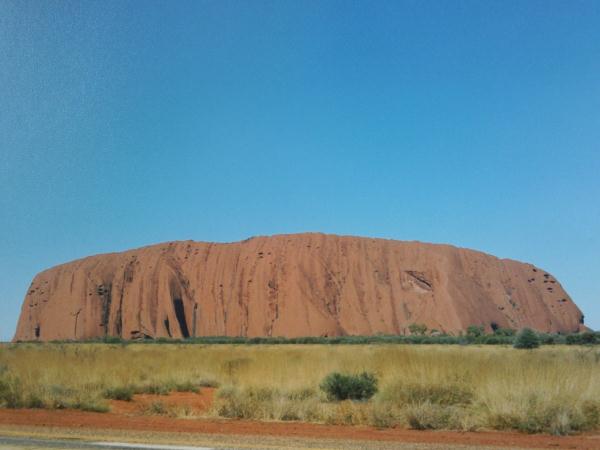
- Uluru/Ayers Rock is made of arkose sandstone
- Uluru/Ayers Rock is naturally grey, but the iron content of the rock is "rusting" at the surface, resulting in the distinctive red iron oxide coating.
- Uluru and Kata Tjuta are the only visible tips of a massive underground rock slab.
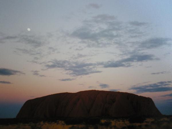
The iron content of Uluru/Ayers Rock is the reason why it has such varied color that changes throughout the day. As the sun shines on it during the day and at different times of the year it’s apperance greatly changes with sunset being an awesome sight when it briefly glows red.
Logging Requirements:
To log this cache (according to Geocaching.com and Earthcache.org requirements) you must perform a geological exercise by making some observations proving that you have learnt something at this cache site. To do this you will need to email 64EH with the answers to the three following questions ( please do not put them in your posted log). It is optional for you to post photos with your log.
Questions:
1- Examine Uluru/Ayers Rock. Describe it’s texture.
2- Uluru/Ayers Rock is a monolith. What is a monolith?
3- What kind of sandstone is Uluru/Ayers Rock?
Photographs:
If you have made the choice to climb, PLEASE DO NOT post photos disclosing this. Other suggestions for those wishing to post photographs are:
1-One photo of yourself holding your GPS with Uluru/Ayers Rock behind you (just to prove you were there)
2-Any photo of Uluru/Ayers Rock . It could be in its entirety, or of a painting in one of the caves, or of the fauna growing around the base of the rock, or…
Additional Hints
(Decrypt)
Rznvy guerr nafjref naq vg vf bcgvbany gb cbfg cubgbf. Purref
Treasures
You'll collect a digital Treasure from one of these collections when you find and log this geocache:

Loading Treasures