What is a artesian well
An artesian aquifer is a confined aquifer containing
groundwaterthat will flow upward through a well, called an artesian
well, without the need for pumping. Water may even reach the ground
surface if the natural pressure is high enough, in which case the
well is called a flowing artesian well.
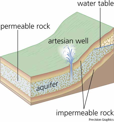
What is a Aquifer
An aquifer is a layer of soft rock, like limestone or sandstone,
that absorbs water from an inlet path. Porous stone is confined
between impermeable rocks or clay. This keeps the pressure high, so
when the water finds an outlet, it overcomes gravity and goes up
instead of down. The recharging of aquifers happens when the water
table at its recharge zone is at a higher elevation than the head
of the well.
Aquifer depth
Aquifers can occur at various depths. Those closer to the
surface are not only more likely to be used for water supply and
irrigation, but are also more likely to be topped up by the local
rainfall. Do you know that a beach provides a model to help
visualize an aquifer. If a hole is dug into the sand, very wet or
saturated sand will be located at a shallow depth. This hole is a
crude well, the wet sand represents an aquifer, and the level to
which the water rises in this hole represents the water table, but
we are not at the beach so the Perine Well here in Alabama will
have to do.
Saturated versus unsaturated
Groundwater can be found at nearly every point in the Earth's
shallow subsurface, to some degree; although aquifers do not
necessarily contain fresh water. The Earth's crust can be divided
into two regions: the saturated zone or phreatic zone (e.g.,
aquifers, aquitards, etc.), where all available spaces are filled
with water, and the unsaturated zone (also called the vadose zone),
where there are still pockets of air with some water, but can be
filled with more water.
Saturatedmeans the pressure head of the water is greater
than atmospheric pressure (it has a gauge pressure > 0). The
definition of the water table is surface where the pressure head is
equal to atmospheric pressure (where gauge pressure =0).
Unsaturatedconditions occur above the water table where
the pressure head is negative (absolute pressure can never be
negative, but gauge pressure can) and the water that incompletely
fills the pores of the aquifer material is under suction. The water
content Unsaturated means the zone is held in place by surface
adhesive forces and it rises above the water table (the zero gauge
pressure isobar) by capillary action to saturate a small zone above
the phreatic surface (the capillary fringe) at less than
atmospheric pressure. This is termed tension saturation and is not
the same as saturation on a water content basis. Water content in a
capillary fringe decreases with increasing distance from the
phreatic surface. The capillary head depends on soil pore size. In
sandy soils with larger pores, the head will be less than in clay
soils with very small pores.
Alabama Water Facts
Approximately 18 percent of all surface water flowing through
the lower 48 states flows through Alabama. Approximately 40 percent
of public water supplies in Alabama are from ground-water sources.
Twenty-seven of 36 south Alabama counties receive all of their
public water supplies from ground-water sources. Alabama has 20
major aquifers that supply water from the land surface to depths
approaching 3,000 feet. The deepest public water supply well is
constructed in the Tuscaloosa Group aquifer in Dale County (2,750
feet). Alabama has an excellent supply of groundwater from a
variety of aquifer systems. There are limestone aquifers in the
Tennessee River Valley capable of supplying high rates of water.
There are unconfined aquifers, which are open to receiving waters
from the surface and that fluctuate depending on recharge rate, and
these aquifers cover a high percentage of the state. The upper
level of unconfined aquifers define the water table and mark the
top of the zone where the spaces between sand and rock particles
are completely saturated with water.
There are several layers of confined aquifers throughout
the East Gulf Coastal Plain physiographic section, which makes up
about two-thirds of the state. Confined aquifers are sandwiched
between layers of material such as clay that make it difficult for
water to move into or out of the aquifer.
The Geological Survey of Alabama has estimated Alabama's
groundwater supply to be 553 trillion gallons of freshwater stored
in 19 major aquifers or aquifer systems across the state. Most
groundwater is considered to be of good quality, except for some
highly mineralized waters underlying the Blackland Prairie area of
west Alabama.The lowest area for groundwater storage in Alabama is
in the southern Piedmont section, where many wells are capable of
yielding no more than 50 gallons per minute, and some no more than
10 gallons per minute. Wells in most other areas of the state are
capable of yielding in excess of 150 gallons per minute.
History of Perine Well
This artesian well was drilled to serve a factory which did not
materialized. It was then used to water the grounds, a garden and
pastures. In addition, by forcing water through pipes into his
$50,000 home, E. M. Perine, a merchant prince, had the first air
conditioning in Alabama. Fry's history relates that when drilled,
this was the deepest known well in the world. Flow is now estimated
at 1250 gallons per minute from a depth of 700-900 feet.

How to get credit for the Earthcache
1.) Which aquifer is feed Perine Well?
2.) Is the aquifer Saturated or unsaturated and explain which
one you believe it is please?
3.) What is the flow rate of the well today?
4.) How cold is water today and is it clear or dirty?
If you like to include a picture when you find this
earthcache then feel free to but it is not require but would be
nice.
You will need to bring a container with you and a something to
gauge how cold the water is.
