Estell Manor Park is located along the Egg Harbor River, and is part of the Atlantic County Park system. The park and surrounding area of Estell Manor has a long history and has been used for many things. Estell Manor was originally owned by the Estell family, who bought the land in the 1820s and soon became involved in the burgeoning southern NJ glass industry. The Estells built a glassworks here in 1826. The Estell family’s wealth grew rapidly and they became involved in timber, shipbuilding, and farming. Their wealth allowed them to live like lords in a large mansion, hence the name Estell Manor. Estell’s glassworks closed in 1877, and remains of the buildings still remain on park property.
In 1918, a munitions factory for World War I was built in this area to supply the massive needs of the war effort. The munitions factory, called the Bethlehem Loading Company, built a massive factory complex along the river, along with housing for over 3,000 employees. This town eventually became known as Belcoville, shortened from Bethlehem Loading Company. This town included a bowling alley, town hall, school, bank, and other stores to support the workers. Construction on the plant and town was started in April, with the first shell leaving the plant only three months later! In addition to the 3,000 plant workers, Belcoville also supported 1,100 soldiers and military barracks to guard the plant. 24 miles of train tracks supplied the plant with raw materials and shipped out finished munitions.
The armistice was signed with Germany in November 1918, although production continued in Belcoville until 1919. No longer needed, the plant and associated town was disassembled for valuable parts, and the remainder was left to ruins, some of which can still be seen in Estell Manor park. After 70+ years, the forest has reclaimed the land, and very little evidence of this once bustling town can be seen. Estell Manor was incorporated as a township in 1925, which is now considered one of the most pristine and natural townships in southern New Jersey. As part of the Pinelands National Reserve, building in Estell Manor is limited to maintain the natural beauty of this once active industrial center. Over one million acres in size, the Pinelands is the country’s first National Reserve and a U. S. Biosphere Reserve of the Man and the Biosphere program.
This Earthcache will take you to an artesian well that was used to supply the Belcoville munitions factory with fresh water. This well was drilled in the early 1900s for the factory and is located next to the ruins of a shell magazine. The well can be accessed via Artesian Well Road off of Route 50, or via the beautiful boardwalk trail which starts at the Warren E. Fox nature center at the main entrance of the park, also off Route 50. This fully accessible boardwalk travels through a variety of ecosystems throughout the park, including Atlantic white cedar swamps and coastal forest. Side trails provide access to the South River. While a beautiful trail, I would not suggest this route during the height of mosquito or horsefly season (I know this from personal experience!)
This artesian well taps the Kirkwood-Cohansey aquifer, which extends through southern NJ, west to Cherry Hill. This shallow aquifer is essential to the pine barrens ecosystem, as water from the aquifer is sometimes located only several feet below the surface, supplying water to pine barren plant life, including Atlantic white-cedars and pitch pine, the dominant tree species in this ecosystem. On average, the pine barrens receives about 44 inches of precipitation per year, with 17 – 20 inches percolating into the Kirkwood-Cohansey aquifer. The aquifer is estimated to contain 17 trillion gallons of water, considered some of the purest water in the United States!
An aquifer is an underground layer of water-bearing permeable rock or unconsolidated materials, such as gravel or sand. The water contained in an aquifer is referred to as groundwater. Aquifers are often tapped via wells to access this water supply for various uses, including drinking water. Although groundwater can be found at many locations below the earth’s surface, not all aquifers contain fresh water. The upper level of an aquifer where the ground is still fully saturated with water is referred to as the water table.
 Sometimes, aquifers are confined between layers of impermeable or poorly permeable rock, such as clay or shale. This confined aquifer contains water under pressure, and if tapped by a well, water will rise to the surface without pumping. A confined aquifer is said to be under artesian pressure, and a well drilled into this aquifer is an artesian well. The word “artesian” comes from the town of Artois in France, which was the old Roman city of Artesium, where monks drilled many artesian wells during the middle ages.
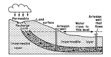
Artesian wells are often formed if the contours of the land produce a confined aquifer where the water table is above the level of the well. Downward pressure from the water table forces water out of the well, sometimes under extreme pressure, which can produce gushing wells forcing water many feet into the sky in its attempt to equalize with the top of the water table (see photo below). Although the artesian well at Estell Manor is not this dramatic, the water flow is endless as it is forced up under pressure from the Kirkwood-Cohansey aquifer.

Wells drilled in aquifers, including artesian wells, can sometimes drain more water from the aquifer than the amount that recharges the aquifer. This can sometimes cause wells to go dry, or allow intrusions from other water sources, such as seawater, to enter the aquifer. The Ogallala aquifer in the arid plains of the U. S. has been used as the primary water source for agricultural irrigation in this region for many years. This aquifer was charged with water during the last ice age, when glacial streams flowed from the Rocky Mountain range and permeated the soil. Recharge in this arid area is minimal, resulting in depletion of this valuable water source. Some predictions indicate this aquifer will be dried up within 25 years. Farmers are now attempting to minimize irrigation and practice water conservation techniques to allow this aquifer to sustain its reserves for many years. Fortunately, aquifer depletion is not an issue in the humid east coast region, and the Kirkwood-Cohansey aquifer will be able to supply fresh water to the pine barrens plants and residents of southern New Jersey for many years to come.
You will need a thermometer with a submergible bulb, a drinking cup, and a camera to claim this Earthcache.
First, take a photo of yourself enjoying a cup of water from the artesian well. Alternatively, take a photo of your GPS near the well outlet or next to a cool cup of the well water. With my research, I attempted to find out if this water was drinkable – I could not find anything definitive, but judging from its set-up and easy access, I am guessing many people fill up their water bottles here. I also drank several bottles of water when I visited with no ill effects. Also, as this water comes from one of the purest aquifers in the country, I am confident it is safe. If you’re still uncomfortable with drinking from a non-confirmed water source, just fake your enjoyment of a cool cup of water in your photo! (Note as of 2015: Apparently, Atlantic County has now deemed this water unsafe to drink as noted by the new sign nearby...so a picture of you or your GPS near the well is fine to include with your log Splashing your fellow geo-buddies is acceptable, too!) If you do take a real drink, describe its taste in your log.
Second, take your thermometer and measure the air temperature and water temperature. In your log, report both measurements and explain why you think the well water temperature differs from the air temperature.
Although not from this area, I spent many summers here visiting my grandparents in nearby Linwood. My mother was born in Bridgeton and grew up in Shiloh, Ocean City, and Linwood. After a losing battle with cancer, she is now buried in the Cedarville cemetery near her parents. I discovered this park while visiting the area this summer, my first trip back to the area following my mother’s funeral in 2008. My mother loved southern New Jersey and the beautiful ocean and pine barrens. May she rest in peace.
Resources:
Pine Barrens website
www.njpinelandsanddownjersey.com
Pinelands Preservation Alliance
www.pinelandsalliance.org
Atlantic County Division of Parks and Recreation (Estell Manor Park and Belcoville)
www.aclink.org/PARKS/mainpages/estell.asp
USGS Water Science for Schools
ga.water.usgs.gov/edu/gwartesian.html