
Die Höhle liegt im mittleren Istrien, in der Gemeinde Žminj, in den Wiesen nahe dem Dorf Feštini. Die Höhle Feštinsko Kraljevstvo wurde nach den Erzählungen der örtlichen Bevölkerung im Jahre 1930 zufällig entdeckt, als bei der Feldarbeit der Boden eines Karsttals einbrach.
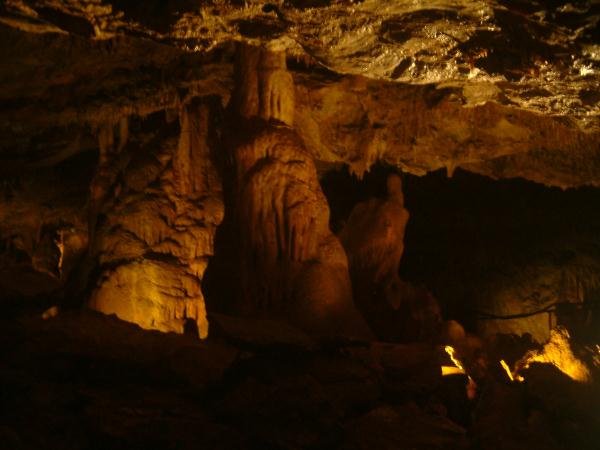
Das Innere der Höhle ist durch etwa einhundert Meter gesicherte Wege erschlossen und jedem Besucher zugänglich. Die Höhle begeistert durch die Schönheit der verschiedenen Tropfsteinformationen, unter denen folgende besondere Aufmerksamkeit erregen: „der Zauberhut“, „der Turm von Babylon“ und die enormen „Fledermausflügel“, über die sich die Wurzel einer Weinrebe erstreckt, die ihr Wasser aus dem Höhlenboden bezieht.
Nach dem zweiten Weltkrieg wurde die Höhle zugeschüttet, aber zu Beginn der achtziger Jahre wieder aufgegraben. Zu diesem Zeitpunkt war sie stark zerstört durch rücksichtslose Besucher, die den Höhlenschmuck abgebrochen und zu Hause zur Dekoration ihrer Wohnungen benutzt haben!
Im Bestreben, weitere Zerstörungen zu verhindern, beschlossen die heutigen Besitzer des Landes, die Höhle dauerhaft zu schützen und für Besichtigungen zu restaurieren. Da sie sich in einem Gelände befindet, das einst von üppiger Waldvegetation bestanden war, ist die Höhle reich an Höhlenschmuck. Dies ist der Grund, dass sie von der örtlichen Bevölkerung auch „FEŠTINER KÖNIGREICH“ genannt wird.
Die Höhle besteht aus einer Halle unregelmäßig-ovaler Form mit einer Gesamtlänge von 67 m und einer Höchstbreite von 27 m sowie einer Tiefe von -9 m. Ihr höchster Bogen ist 6 m hoch. Die Durchschnittstemperatur in der Höhle beträgt 13 – 15 Grad.
Geschichte:
Die Höhle wurde in den dreißiger Jahren des vergangenen Jahrhunderts entdeckt, als _ _ _ _ Božac, den man auch „Fajtar“ (von dt. „Gefreiter“) nannte, beim Bepflanzen seines Weinbergs zufällig auf die Höhle stieß. Ihm war nämlich beim Graben eines Lochs für die Pflanzung einer neuen Rebe seine Hacke in die Grube gefallen.
Damals ahnte er nicht, was sich in dem Loch verbarg, sondern er beschloss, es zuzuschütten, um mögliche Unfälle zu vermeiden. Aber dann gelang es ihm nicht, das Loch ganz zu füllen, denn es fiel immer neue Erde hindurch. Die Zeit verging, und noch immer wusste niemand, was da unter dem Weinberg des alten Tone Frajtar schlummerte.
Aber während der italienischen Besetzung Istriens, in den vierziger Jahren, beschlossen die Anwohner zu untersuchen, was es mit diesem Loch auf sich hatte, denn sie suchten eine Zuflucht vor den bevorstehenden Gefahren des Krieges. Als sie das Loch aufgruben, öffnete sich vor ihnen der Eingang in die Höhle. Alle waren von dem Anblick beeindruckt und konnten nicht glauben, was sich alles unter dem Boden ihres Dorfes verborgen gehalten hatte.
Kinder aus anderen Dörfern kamen, um die Höhle anzuschauen, und wenn ihre Eltern sie fragten, wo sie gewesen waren, antworteten die Kinder, dass sie im „Königreich“ waren. Und so wird die Höhle heute noch immer „Feštiner Königreich“ genannt.
In den gefährlichen Kriegsjahren erlitt das Dorf Feštini eine schwere Tragödie. Alle erwachsenen, männlichen Dorfbewohner wurden ermordet. Nur Josip „Bepo“ Božac, der Sohn „Frajtars“, überlebte, da er sich in der Höhle verborgen hatte!
In der interessanten Geschichte der Höhle gab es auch eine tragikomische Situation. Ein kleines verspieltes Eselfohlen, das den dortigen Bauern mehr wert war als ein Schatz, spielte in der Nähe des Lochs und fiel in die Höhle. Glücklicherweise verletzte er sich dabei nicht, sondern war nur zutiefst verstört. Nachdem die Bauern ihn geborgen hatten, scherzten sie darüber, dass nun auch der kleine Esel im Königreich gewesen war.
HR:
O špilji:
U srcu Istre, kraj sela Feštini nedaleko Žminja svojim se prirodnim ljepotama ističe špilja Feštinsko kraljevstvo. Ulazeći u špilju čujete skladan zvuk kapljica koje od pamtivijeka stvaraju prekrasan podzemni nakit ispod kojeg se zrcale jezerca puna vode nakapnice.
Unutrašnjost špilje uređena je sigurnim stazama duljine stotinjak metara, te dostupna svakom posjetitelju. Špilja oduševljava ljepotom raznolikih sigastih oblika među kojima se posebno ističu: „čarobnjakov šešir“, „kula babilonska“ i ogromna „šišmiševa krila“ preko kojih se proteže korijen vinove loze, koja crpi vodu sa špiljskog dna.
Špilja se nalazi u središnjoj Istri, općina Žminj, na pašnjaku nedaleko sela Feštini. Špilja Feštinsko kraljevstvo je po pričanju, mještana slučajno otkrivena 1930. kad se prilikom obrađivanja njive urušilo dno vrtače.
Nakon drugog svjetskog rata, špilja je zatrpana, te je ponovno otkopana početkom osamdesetih godina. U to vrijeme bila je i dosta devastirana od strane nesavjesnih posjetitelja koji su otkidali špiljske ukrase te ih koristili za ukrašavanje okućnice!
U želji sprečavanja daljnje devastacije, današnji vlasnici zemljišta odlučili su špilju trajno zaštititi i cjelovito urediti za razgledavanje. Budući da se nalazi na terenu nekad pokrivenim bujnom šumskom vegetacijom, špilja obiluje špiljskim ukrasima, po kojima je od strane mještana i nazvana „FEŠTINSKO KRALJEVSTVO“.
Špilja oduševljava ljepotom raznolikih sigastih oblika, među kojima se posebno ističu ´čarobnjakov šešir´, ´kula babilonska´ i golema ´šišmišova krila´, preko kojih se proteže ogranak korijena vinove loze. Špilja je u naravi jedna dvorana nepravilnog ovalnog oblika ukupne dužine 67 m, najveće širine 27 m, dubine -9 m i najveće visine svoda 6 m. Prosječna temperatura u špilji je 13-15 stupnjeva.
Povijest
Špilja je otkrivena tridesetih godina prošlog stoljeća, kada je _ _ _ _ Božac zvani „Frajtar“ prilikom sadnje vinograda slučajno otkrio špilju. Naime, prlikom kopanja rupe za sadnju novog trsa, propao mu je „pikun“ (kramp) u jamu.
On u to vrijeme nije ni slutio što se krije u toj rupi, nego je odlučio da će je zatrpati da spriječi moguće nesreće. No prilikom zatrpavanja nikako nije uspio do kraja zatrpati rupu, jer je uvijek zemlja iznova propadala.Vrijeme je prolazilo i nitko još nije znao što se nalazi ispod vinograda barba Toneta Frajtara.
No prilikom talijanske okupacije Istre, četrdesetih godina mještani su odlučili provjeriti što se nalazi u toj rupi. Naime htjeli su naći zaklon od nadolazeće ratne opasnosti. Nakon što je rupa iskopana, otvorio se prolaz u špilju. Svi su bili zadivljeni viđenim, te nisu mogli vjerovati što se sve skriva u podzemlju njihovog sela.
Djeca iz drugih sela su dolazila pogledati špilju i kad su ih roditelji pitali gdje su bili, djeca su odgovorila da su bila u „kraljevstvu“. Tako se dan danas špilja zove „Feštinsko kraljevstvo“.
Za vrijeme opasnih ratnih vremena, selo Feštini pogodila je velika tragedija. Ubijeni su svi odrasli muški mještani. Samo je Josip „Bepo“ Božac, sin prije spomenutog „Frajtara“ preživio zahvaljujući tome što se skrivao u špilji!
U zanimljivoj povijesti špilje dogodila se i jedna tragikomična situacija. Mali nestašni magarčić (pulić), koji je ondašnjim seljacima značio više od blaga, igrajući se u blizini rupe, propao je u jamu. Na sreću nije bio ozlijeđen nego samo prestrašen. Dok su ga izvlačili mještani su se šalili kako je i mali pulić bio u kraljevstvu.
EN:
About the cave
In the heart of Istria near the village of Feštini close to Žminj, with its natural beauties is the Feštini Kingdom Cave. Entering the cave, you can hear the harmonious sound of the water lets that from time immemorial have created wonderful underground treasures reflected in small pools of water.
been equipped with safe walkways that are accessible to every visitor. The cave inspires visitors with the variety of its stalactite and stalagmite formations, especially The Magician´s Hat, The Tower of Babylon, and the huge Bat´s Wing, through the latter of which the roots of the grapevines above draw water from the floor of the cave.
The cave is located in central Istria in the District of Žminj in a pasture close to the village of Feštini. According to a local story, the site was accidentally discovered in 1930, when the floor of the karst valley collapsed while the field was being cultivated.
After World War II, the cave was covered up, but was re-opened at the beginning of the 1980s. During that time, it was damaged by unthoughtful visitors who removed many of the cave´s stone features and used them to decorate their yards!
To prevent further devastation, the current landowners have decided to protect it and to completely equip it for viewing. Since the cave is located on land once covered by thick forest vegetation, the cave and its beautiful features have been named THE FEŠTINA KINGDOM by the inhabitants of the village.
The cave thrills visitors with the beauty and variety of its stalactite and stalagmite formations, especially The Magician´s Hat, The Tower of Babylon, and the huge Bat´s Wing, through the latter of which extend the roots of the grapevines above. The cave is in the shape of an irregular oval. It has a total length of 67 meters, it widest expanse is 27 meters, its depth is nine meters, and its highest point is six meters. The average temperature in the cave is 13-15 degrees Centigrade.
History:
The cave was discovered in the 1930s, when _ _ _ _ Božac known locally as Fraitar accidentally uncovered it. While digging holes to plant new grapevines, his pick fell through a hole and into the cave below.
At that time he had no idea what was concealed beneath the hole, so he tried to fill it up to prevent an accident. But he could not succeed in filling in the hole completely because the dirt kept sinking through it. Time passed and no one knew what was located under Fraitar´s vineyard.
During the Italian occupation of Istria in the 1940s, the inhabitants of the village decided to find out what was beneath the hole. They were most interested in finding a shelter from the constant dangers of the war. After the hole was dug out, the entrance to the cave was opened. Everyone was amazed at what they saw and could not believe what was hidden beneath the ground of their village.
Children from the neighboring villages came to see the cave. When their parents asked where they had been, they answered that they had been in the kingdom. So today the cave is call The Feštini Kingdom.
During the war, the village of Feštini suffered a great tragedy. All of the adult men in the village were killed. Only Josip Bepo Božac, the son of Fraitar, survived because he hid in the cave!
There was one other tragicomic situation in the interesting history of the cave. A small playful donkey, which meant more to the villagers than treasure, fell into the cave while playing near its opening. Fortunately, he was not injured, only frightened. When the villagers pulled him out of the cave, they joked how the little donkey had been in the kingdom.
DE:
In Kroatien herrschen Höhlen vor, die sich durch die chemische und die mechanische Wirkung des Wassers in den Kalkstein- und Dolomitschichten des Karstreliefs gebildet haben. Außer in diesen Felsen haben sich Höhlen auch in Felsen aus Gips-, Salz- und Magmaschichten und in Konglomeraten gebildet. Unter Karst versteht man in der Geologie und Geomorphologie unterirdische und oberirdische Geländeformen in Karbonatgesteinen (zum Teil auch in Sulfat- und Salzgesteinen), die vorwiegend durch Lösungs- und Kohlensäureverwitterung sowie Ausfällung von biogenen Kalksteinen und ähnlichen Sedimenten mit hohen Gehalten an Calciumcarbonat (CaCO3) entstanden sind. Hauptmerkmal ist der überwiegend unterirdische Wasserhaushalt, der nicht auf einer primären Porosität des Gesteins beruht, sondern vielmehr sekundär durch den in geologischer Zeit stattfindenden Prozess der Verkarstung (=Korrosion) bedingt wird. Dadurch sind Landschaften, die überwiegend von Karbonaten aufgebaut werden, als Karstlandschaften ausgebildet. Außer in Kroatien sind Karstlandschaften in Südostasien, Südchina und Großen Antillen zu finden.
HR:
U Hrvatska dominira po špiljama koje su formirane kroz kemijska i mehanička djelovanja vode u vapnenačkih i dolomitnih slojeva krškog reljefa. Osim u tim stijenama špilje su nastala u stijenama od gipsa, soli i Magma slojeva i konglomerata. Pod Karst shvati u geologiji i geomorfologije i pod zemljom terena u karbonatnim stijenama (neki čak iu sulfata i soli stijena), pretežno rješenje i ugljične kiseline starenje i oborina od biogenih vapnenca i slične sedimenata formirana sa visokim sadržajem kalcija karbonata (CaCO3) jesu. Glavne karakteristike su uglavnom podzemnih voda, a ne na temelju primarne poroznosti stijene, nego sekundarne na proces odvija u geološkom vremenu okršavanje (korozija =) određuje. To čini krajolike koji su izgradili uglavnom karbonata, kao krških krajolika oblikovana. Osim u krškim krajolicima Hrvatska u jugoistočnoj Aziji, južnoj Kini i Veliki Antili nalaze.
EN:
In Croatia dominated by caves that have formed through chemical and mechanical action of the water in the limestone and dolomite layers of the karst topography. Except in these rocks are caves have formed in rocks of gypsum, salt and magma layers and conglomerates. Under Karst is understood in the geology and geomorphology and under ground terrain in carbonate rocks (some even in sulfate-and salt rocks), the predominantly by solution and carbonic acid weathering and precipitation of biogenic limestone and similar sediments formed with high contents of calcium carbonate (CaCO3) are. Main features are mainly underground water, not based on a primary porosity of the rock, but rather secondary to the process taking place in geological time of karstification (= corrosion) is determined. This makes landscapes that are built up mainly of carbonates, as karst landscapes formed. Except in Croatia karst landscapes in Southeast Asia, southern China and Greater Antilles are found.
___________________________________________________________________
Ein Foto mit dir und deinem GPS am Eingang der Höhle ist immer gerne gesehen. (Foto)
DE: Um diesen Earthcache loggen zu dürfen, musst du folgende Fragen beantworten,
-
Wer hat in den dreißiger Jahren die Höhle entdeckt? _ _ _ _ Božac
-
Wie viel Stufen sind es bis vor die Eisen Tür zur Höhle?
-
Höhlen, die keine Verbindung zur Oberfläche haben, nennt man?
-
Auf dem Weg zur Höhle kommt ihr an diesen Tor (Tor Link) vorbei, wie lautet die Haunummer auf dem Schild Links neben dem Tor?
Schickt eure Antworten per Mail über mein Profil Send Email
oder nutzt diese alternative Logmöglichkeit; setzt eure Antworten zu einer E-Mail Adresse zusammen
1-2-3-4@t-online.de Beispiel: Bill-56-Höhlen-87@t-online.de
Fotografiju s Vama i Vaš GPS na ulazu u špilju je uvijek dobrodošao. (Foto)
HR: Da biste se prijavili ove cache mora odgovoriti na sljedeća pitanja imate.
-
Tko je otkrio špilja u tridesetima?_ _ _ _ Božac
-
Koliko koraka ima do ispred same špilje željeza vrata?
-
Špilje koje nemaju spoj s površinom nazivaju se?
-
Na putu do špilje ste došli na ova vrata (vrata na link), kao kuća broj se nalazi na znak lijevo od vrata?
Pošaljite svoje odgovore putem e-maila preko mog profila pošaljite Send Email
ili koristiti ovaj alternativni dnevnik; stavlja svoje odgovore na e-mail adresu zajedno
1-2-3-4@t-online.de Primjer: Bill-56-Caves-87@t-online.de
A photo with you and your GPS at the entrance of the cave is always welcome. (Photo)
EN: To log this earthcache, send an email with the answers of the following questions in english or german.
-
Who discovered the cave in the thirties?_ _ _ _ Božac
-
How many steps there are up to the front of the iron door cave?
-
Caves that have no connection with the surface are called?
-
On the way to the cave you come to this gate (Gate link over), as the house number is on the sign left of the gate?
Send your answers via e-mail via my profile Send Email
or use this alternative Log; puts your answers to an email address together
1-2-3-4@t-online.de Example: Bill-56-Caves-87@t-online.de
______________________________________________________________________________
Wenn ihr möchtet könnt ihr euren Besuch in diesen Gästebuch eintragen.
Ako želite možete o tvoj posjet ovu knjigu.
If you want you can about your visit to this guestbook.


Quellen / Sources:
-Informationstafel vor Ort /-Board of Information
-Wikipedia
Quelle: http://www.sige.hr
