C&S Nighthawk Branch Traditional Cache
-
Difficulty:
-

-
Terrain:
-

Size:  (micro)
Please note Use of geocaching.com services is subject to the terms and conditions
in our disclaimer.
This is another cache in series of caches started by Grand High
Pobah dedicated to Fallen Flag railroads. Fallen Flags are those
railroads that no longer exist either through abandonment or
corporate takeover.
The Denver, South Park and Pacific railroad was a narrow gauge line
(3’ between the rails) that ran from Denver up the Platte
River through Waterton Canyon and eventually over Kenosha Pass. At
the confluence of the two branches of the South Platte River right
by the old South Platte Hotel, the railroad emerged from the canyon
with the mainline following the branch to the north.
Running up the south branch, however, was a short lived line that
has an interesting history. It ran only 4 miles from South Platte
to Nighthawk. Here is a picture of the historical sign a few
hundred feet south of the cache:
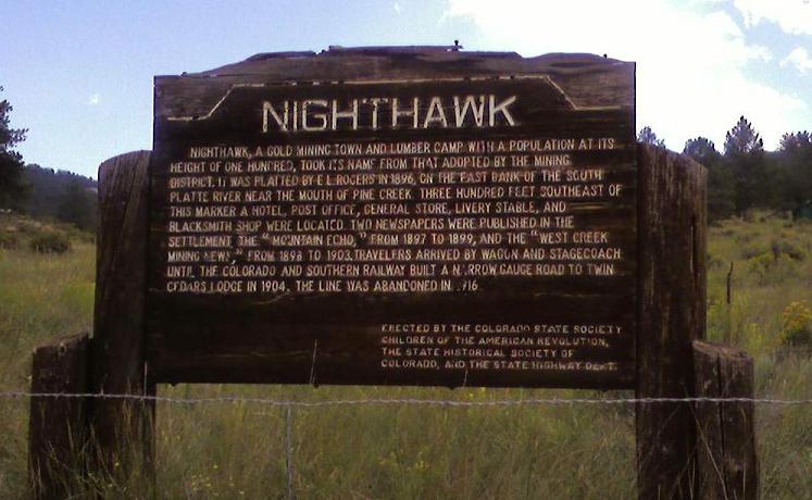
Construction started on this line in 1899 after the DSP&P had
become the Colorado and Southern. It was abandoned and completely
removed by 1916.
The line diverged from the main line and ran behind the South
Platte Hotel crossing the river to run south on the west side of
the river. It crossed over to the east side a mile or so south of
South Platte. From there to Nighthawk, it ran more or less right
where the road is today.
When this line was constructed, the railroad had in mind two things
(besides making some money, that is). It was to be a "short" line
that would go all the way to Cripple Creek via a connection with
the Colorado Midland at Lake George. This line was built as narrow
gauge but could have been converted to standard gauge at a later
time. The other reason was to "defeat" the plans of the Denver and
Rio Grande railroad. The D&RG wanted to build a competing line
from Acequia through Waterton Canyon and then south on this very
same route. The C&S beat them to it but not before the D&RG
could actually grade some of their line only part of which you can
see today. One part is at South Platte heading into the canyon on
the south side of the river. If you head to the Critter Cache by
the River cache (GCY74Y), you will be hiking on that grade. No
rails were ever laid there, though. The other part of the grade
that I am aware of has been inundated by the Strontia Springs
Reservoir downstream in the canyon.
Additional Hints
(Decrypt)
Fgneg ng gur fgbc fvta naq urnq hc gur tragyr vapyvar gb gur fznyy gerr.
Treasures
You'll collect a digital Treasure from one of these collections when you find and log this geocache:

Loading Treasures