The Intracoastal Waterway is a 3,000-mile (4,800-km) waterway
which runs for most of the length of the Eastern Seaboard along the
Atlantic and Gulf coasts of the United States. It's unofficial
northern terminus at the Manasquan River in New Jersey, where it
connects with the Atlantic Ocean at the Manasquan Inlet, then
around the Gulf of Mexico to Brownsville, Texas. Some lengths
consist of natural inlets, salt-water rivers, bays, and sounds;
others are artificial canals. It provides a navigable route along
its length without many of the hazards of travel on the open
sea.
The Intracoastal Waterway connects the Atlantic Ocean and the
Gulf of Mexico to several navigable rivers and inlets where
shipping traffic can travel to inland ports, including the
Mississippi, Alabama, Savannah, James, Susquehanna, Delaware,
Hudson, and Connecticut Rivers.
Cape May Canal ~ Intracoastal Waterway
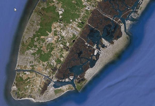
The Cape May Canal is a waterway that stretches nearly three
miles from Cape May Harbor to the Delaware Bay, at the southern tip
of Cape May County, New Jersey. The canal was constructed by the
United States Army Corps of Engineers during World War II to
provide a protected route to avoid German U-boats operating off
Cape May Point and to become part of the Intracoastal Waterway. The
canal was dredged as a wartime emergency measure in 1942 and was
the final link in a protected waterway intended to allow coastal
shipping to travel along the coast with a greatly reduced risk of
attack from German submarines.
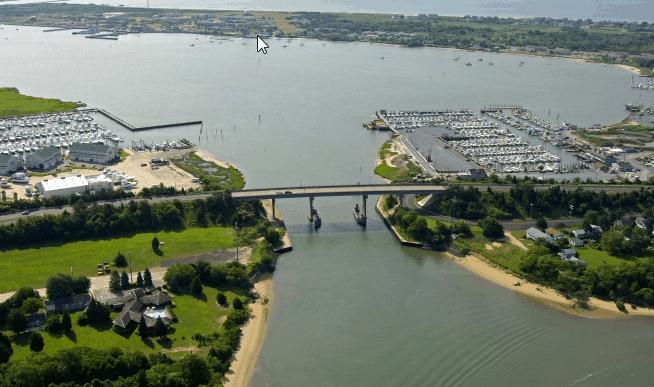
 The Cape May Canal ~ West to the Delaware Bay
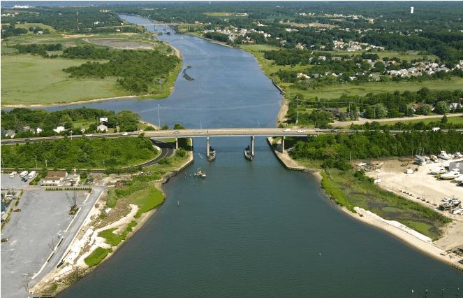
 The Cape May Canal ~ East to the Atlantic
 Arial view of the Cape May Canal
The canal completed Cape Island, which includes Cape May, Cape
May Point, West Cape May and the southernmost portions of Lower
Township. The island is separated from the mainland and the rest of
Cape May County by the Cape May Canal, Cape Island Creek and Cape
May Harbor which cut it off from the rest of the peninsula.
There are three bridges across the canal: Route 109 (the link
from the Garden State Parkway into Cape May), Route 162 (Seashore
Road into West Cape May), and the railroad drawbridge of the Cape
May Seashore Lines.
CAPE MAY CANAL TIDE / CURRENT:
The current in the canal flows the opposite way that it would if
the canal were a river emptying into the bay. When the tide is
moving from low to high (flood tide), the canal current is flowing
west toward the Delaware Bay.
EARTHCACHE.ORG GUIDELINES FOR LOGGING AN EARTHCACHE:
EarthCache sites must provide Earth science lessons. They take
people to sites that can help explain the formation of landscapes
or to sites of interesting phenomena such as folds, faults,
intrusions or reveal how scientists understand our Earth (such as
fossil sites etc.) EarthCache sites must be educational. They
provide accurate but simple explanations of what visitors will
experience at the site. Logging of an EarthCache must involve
visitors undertaking some educational task that relates to the
Earth science at the site. This could involve measuring or
estimating the size of some feature or aspect of the site,
collecting and recording data
TO LOG THIS EARTHCACHE YOU MUST LOG PER THE FOLLOWING
INSTRUCTIONS:
You must visit the area and answer an earth science question.
There is no container or logbook for you to sign just a beautiful
and unique natural feature to observe.
Take note of the tide and direction of current flowing water in
the canal, and describe the flow direction towards west, Delaware
Bay or towards the east ~ Atlantic ocean.
1. To log this cache you must record the time of your visit as
it relates to the incoming or outgoing tides, (see tide chart
below) and what you observe, height of the tide, rough or calm
water, and direction. Include anything else you observed. An
example of a log might be: Arrived at 4:30 p.m. which was 1 hour
after high tide, and the water was flowing to east, there was
turbulence with wave height up to two feet high. There were several
sea birds fishing, and many boats at the time of our visit.
2. You must post a photo of your and or your GPS with the Cape
May Canal in the background. Include as many canal photos as you
would like. Enjoy.
Over time, as the logs accumulate visitors will realize if they
want to have the best view of this tidal phenomenon, the time that
they should visit Cape May Tidal charts are available at:
Tides.Info: Tide Predictions for Cape May, Atlantic Ocean, New
Jersey
HISTORY:
The creation of the Intracoastal Waterway was authorized by the
United States Congress in 1919. It is maintained by the United
States Army Corps of Engineers. Federal law provides for the
waterway to be maintained at a minimum depth of 12 ft (4 m) for
most of its length, but inadequate funding has prevented that.
Consequently, shoaling or shallow water are problems along several
sections of the waterway; some parts have 7-ft (2.1-m) and 9-ft
(2.7-m) minimum depths.
First publicly conceived in 1808 by the U.S. Secretary of the
Treasury, Albert Gallatin, the concept of a national, protected,
north-south waterway was introduced in his report to President
Thomas Jefferson that year. Gallatin noted that the United States
possessed an inland navigation solution from Massachusetts to
Georgia (then the southernmost Atlantic state) that was
"principally, if not solely" interrupted by a mere four stretches
of land - Cape Cod, a section of New Jersey between the Raritan and
Delaware rivers, the peninsula between the Delaware River and the
Chesapeake Bay, and the marshy tract between the Chesapeake Bay and
the Albemarle Sound.
By 1808, there were but a handful of fairly successful manmade
canals in the country, and many more were either already under
construction or soon would be. Gallatin explained in his report
that if the federal government would appropriate the necessary
funds then these mere four stretches of land could be dredged with
new canals, therefore a sea vessel could travel by rivers, bays,
sounds, and a handful of canals from Boston to Beaufort, North
Carolina, on down to the Cape Fear River, then broken by a short
ocean run the inland navigation could continue again inside the
chain of barrier islands skirting the coasts of South Carolina and
Georgia.
Secretary Gallatin estimated that the cost of the four canals
would be $3 million. His entire scheme for roads and canals would
cost an expected $20 million. By setting aside $2 million per year
from the annual Treasury surplus (then in excess of $5 million),
the whole project envisioned could be accomplished within ten (10)
years.
Delayed by foreign problems (the War of 1812 comes to mind) and
further frustrated by domestic obstructions (President Jefferson
was not entirely sold on the idea), Gallatin's plan was never fully
implemented. His concept of an Intracoastal Waterway never died,
but the waterway ultimately came into being mostly due to local
projects rather than centralized planning during the nineteenth
century. And instead of taking ten years, its construction spanned
more than a century.
The Atlantic Intracoastal Waterway, conceived by Secretary
Albert Gallatin in 1808, was not essentially completed until the
1930s - in the midst of the Great Depression. It is a hybrid
creation of man comprised of many existing (although upgraded)
riverways, man-made canals, and existing sounds and bays. The
waterway came into being through a series of local projects
developed in expectation of local benefits. Today, commerce south
of Norfolk is almost entirely domestic and mostly short haul. It is
now used more for recreation than for commerce. And, it is no
longer maintained to the width and depth as it was during the peak
of its usage.