Großes Torfmoor
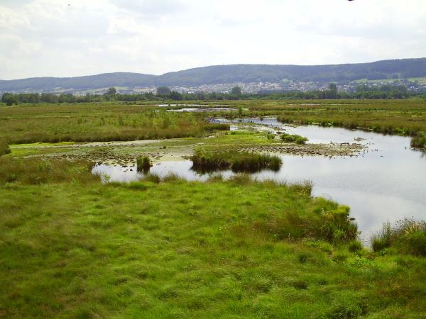
Das Große Torfmoor (auch: Hiller Moor oder Nettelstedter Moor) ist ein Hochmoor und Naturschutzgebiet im Nordosten Nordrhein-Westfalens in den Gemeinden Lübbecke und Hille. Das Moor liegt in einer Niederung zwischen Wiehengebirge und Mittellandkanal und ist mit 467 ha das bedeutendste Hochmoor Westfalens.
Fauna und Flora
Das "Große Torfmoor" weist heute eine gebüsch- und gehölzarme Kernzone mit ausgedehnten Hochmoorregenerationsstadien und umfangreichen Feuchtheideflächen und degenerierten Pfeifengrasbeständen auf. Die Randbereiche bestehen überwiegend aus Moorwäldern, Moorgebüschen, Röhrichten, Rieden und zahlreichen Gewässern.
Das Gebiet dient einer Vielzahl von Vögeln, wie z. B. der Bekassine, der Krickente, dem Großen Brachvogel, dem Weißstorch und sogar dem Kranich als Brut-, Nahrungs-, Durchzugs- und Siedlungsraum.
Entstehung
Vor etwa 11.000 Jahren bildete die Weser im Bereich des heutigen Moores einen Rinnensee. Die Weser wurde damals durch Gletscher daran gehindert, wie heute einen nördlichen Verlauf zu nehmen, und verlief nördlich des Wiehengebirges in westlicher Richtung. Als die Gletscher abschmolzen und die Weser wieder nordwärts floss, verlandete der Rinnensee und wurde ein Moor, das sich über 20 Kilometer nördlich des Wiehengebirges parallel zu diesem Gebirge hinzog.
Die maximale Breite dieses "Urmoores" betrug damals noch drei Kilometer. Zunächst entwickelte sich ein Niedermoor, dann aber nach und nach ein Hochmoor, dessen Reste heute als Großes Torfmoor bezeichnet werden.
Hochmoore
Hochmoore sind einzigartige Landschaftselemente. Sie zeichnen sich durch einen fast stets vorhandenen Wasserüberschuss aus. Man könnte sie mit vollgesogenen Schwämmen vergleichen (bis zu 90% Wasser), die erhaben in der Landschaft liegen. Daher rührt die Bezeichnung Hochmoor. Hochmoore leben allein vom Regenwasser.

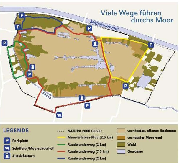
Im Rahmen des EU-LIFE-NATUR-Programms wurden Aussichtstürme und ein toller Moor-Erlebnispfad errichtet, der an den o. a. Koordinaten gestartet werden kann (auf der Karte der Parkplatz oben rechts) und auch für Kinder sehr spannend und erlebnisreich ist.
Loggen
Um den Cache zu loggen, musst du ein Foto mit der Informationstafel an den Startkoordinaten uploaden. Auf dem Foto kannst du selbst sein oder wenn du das nicht möchtest, ein Zettel mit deinem Cachernamen.
Außerdem beantworte bitte folgende Fragen und sende mir die Ergebnisse per Mail oder Message:
- Wann begann die Entstehung des Großes Torfmoors?
- Ist das Große Torfmoor ein Hochmoor, Übergangsmoor oder Niedermoor? Bitte begründe deine Annahme.
- Wo kann ein Moor wie das Große Torfmoor nicht entstehen? Nenne ein Gebiet und begründe, warum du meinst, dass es dort nicht entstehen kann.
Du kannst sofort loggen, sollte etwas nicht in Ordnung sein, melde ich mich.
English version:
The Großes Torfmoor (also Hiller Moor or Nettelstedt Moor) is a moor and nature reserve in north-eastern North Rhine-Westphalia in the communities Lübbecke and Hille. The moor is located in a valley between Wiehengebirge and Mittellandkanal and having 467 ha it is the largest hill moor in Westphalia.
Fauna and Flora
The "Großes Torfmoor" has a bushes and flowering poor central zone with extensive hill moor regeneration stages and degenerated Molinia stands. The borders consist mainly of moor woodland, moor-bushes, reedbeds, vineyards and many waters.
The area serves as breeding, feeding, transit and settlement to a variety of birds such as snipe, the teal, the Eurasian curlew, the stork and even the crane.
Formation
About 11,000 years ago the Weser formed a small lake in the area of present-day. At that time the Weser was prevented by glaciers to take a northern course and went north of the Wiehengebirge to the west. As the glaciers melted away and the river flowed northward again, the small lake silted and became a swamp with an extension of 20 km. The maximum width of this old moor was 3 km. First there developed a low moor, but gradually a hill moor. The remains of this hill more are the "Großes Torfmoor".
Hill moors
Hill moors are unique landscape features. They are tagged with excess water and might be compared with saturated sponges (up to 90% water), which are sublime in the landscape. Hence the term hill moor. Hill moors are living on rainwater only.
As part of the EU LIFE NATURE-program observation towers and a great moor-trail were set up. It can be started at the coordinates above (the parking area on the map above right) and also for children the trail is very exciting and eventful.
Sign in
To log the cache, you must upload a photo featuring the information board located at the starting coordinates. The photo can show you, or - if you prefer - a slip of paper with your cacher name.
In addition please answer the following questions and send me the results via email or message:
-
When did the formation of the Großes Torfmoor begin?
-
Is the Große Torfmoor a raised bog, a transitional bog, or a fen? Please explain the reasoning behind your conclusion.
-
Where could a bog like the Große Torfmoor not form? Name an area and explain why you think it could not form there.
You can log it right away; if anything is amiss, I’ll get in touch.