Oxbow (Mirror) Lakes on the road to Milford Sound EarthCache
Oxbow (Mirror) Lakes on the road to Milford Sound
Related Web Page
Please note Use of geocaching.com services is subject to the terms and conditions
in our disclaimer.
A very easily accessible earthcache, which appears to be one of the stopping points for all the tour buses on the road to Milford Sound from Te Anau (and Queenstown). It is probably wheelchair accessible. All information required can be gathered from the public information signs posted there.
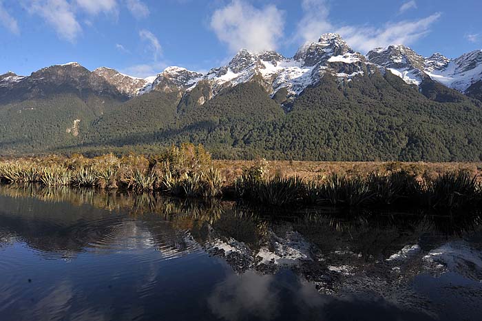
It's easy to see where the name "Mirror" comes from...
Some rivers flow in fairly straight lines. Other rivers snake around in large S shapes. It is these latter rivers that can cause Oxbox lakes (or as the Aussies like to call them - Billabongs).
Essentially these snaking rivers will straighten out over a long period of time. Natural erosion will nibble away at the bend of the S shape, and eventually take a short cut through. The bend will then get cut off from the river and can leave a horse shoe shaped lake behind.
Natural erosion occurs because water on the outside of a bend travels faster than water on the inside of the bend. The outside therefore erodes, whilst sediments and silt get deposited on the inside of the bend. The distance between either sides of the bend in the river there gets smaller and smaller, until one day the river cuts all the way through and then the oxbow lake starts to form.
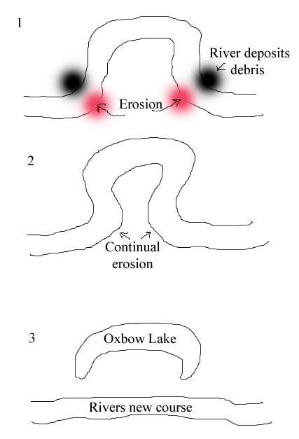
My simplified picture showing the creation of an Oxbow Lake
Sometimes Oxbow lakes can occur when a river is artificially straightened, or when for example a huge flood bulldozes the river banks and straightens a river out.
The related Wikipedia article linked at the top of this page explains the process very well.
The lake you will see here is now several hundred metres from the current path of the Eglinton River (the river that formed this Oxbow Lake), so you can get an idea of just how much a river can change its course over time.
To log this cache, please answer the following questions by email (please do NOT put the answers in your log):
1) - What is the name of this South West New Zealand World Heritage Area (I am looking for 2 words, a very short one, and a very long one)
2) - What range of Mountains is shown on the Mirror Lakes sign?
3) - On the last of the picture signs you come to before you get back on your bus (i.e. the sign nearest to Milford Sound), there are the words "What's Out There?". Then there is a line of text just underneath it which is 5 words long and starts with "in the". Please tell me what the last 3 words are.
4) - Optionally - take a photo of yourself or your GPS in front of the Oxbox / Mirror Lake.
Additional Hints
(Decrypt)
Ernq gur Choyvp Vasbezngvba Fvtaf sbe gur nafjref
Treasures
You'll collect a digital Treasure from one of these collections when you find and log this geocache:

Loading Treasures