
EN:
General description
Its name "Red Lake" comes from the color of surrounding cliffs, which contrast with the bright blue color of lake. These walls are reddish-brown.
Sinkhole is roughly circular, with nearly vertical, extremely tall walls and deep blue lake far below. Walls are nearly vertical from three sides and slanted from the fourth. This fourth side collapsed during the earthquake in 1942.
Color of the lake changes from green to dark blue, depending on the sky above it.
Volume of whole sinkhole is estimated to be 25 - 30 million m3, volume of lake is at least 7 million m3.
Diameter of the lake is some 200 m. The known depth of lake is 280 - 290 m. Data about the depth of lake are somewhat controversial. This can be easily explained - the level of lake may change per 30 - 50 m.
Level of lake can change even 1 m per day - what requires a flow of hundreds of millions of litres per day.
Bottom of this lake is located at least 5 metres below the level of sea. Thus the original cave, which formed this sinkhole, formed during the ice ages, when sea level was lower.
When the level of lake is lower, it is not available - cliffs over the last 30 m are overhanging all around the lake. Though - if the level of lake rises, it becomes available - but also after hard and risky climb.
Bathing in the lake water for most part is really chilly - above it may warm up - but not too much as the Sun reaches it for too short time. Deeper the temperature of water falls to 7 - 8 °C, water is very very clean and lucid.
The Red Lake has been most likely formed by collapse of enormous cave hall. It seems to be the youngest of Imotski sinkholes - due to its vertical walls. But may be it simply has more active underground river which does not let to accumulate sediments.
Smaller caves
Near the water level of lake there have formed smaller caves. One of such caves - Czepitschka Cave - has been explored in 1998. It has one entrance above the water level and another - below it. Total length of this cave is 670 m.
Some other caves are Kik-kak (some 15 m long), Balkon Prijatelstva. These caves have formed by the intermittent level of water in the lake.
Exploration
The Red Lake is known since ancient times. But I know about just one serious exploration expedition to this sinkhole. This expedition was organised in 1998 by German, Austrian and Croatian speleologists and scientists, led by Aspacher, Behrend, Haslinger, Hilbert. This was complex expedition, requiring very high expertise and experience in climbing and deep diving.
In hard work there was obtained valuable information. Fore example, explorers met powerful underwater stream at 170 m depth. Thus most likely this sinkhole is crossed by a powerful underground stream.
This explains also why there was not noticed a layer of debris on the floor of lake.
In fact one of the highest dangers for any explorer here is posed by the falling cliffs. On their way back to the surface explorers learned how dangerous it may become: during the thunderstorm collapsed enormous cliffs and after several hundred metres high free fall splashed in the lake. Even in calm weather occasional stones fall in the lake.
Mysterious fish
The Red Lake contains several organisms who live only here and nowhere else in the world. One of them is small, up to 12 cm long fish - Delminichthys adspersus (Heckel, 1843). In fact this fish occasionally, during dry winters and springs, can be seen in springs in the region around the sinkhole - it then spreads even in the surrounding rivers and lakes. This means that Red Lake has underground connections to these springs.
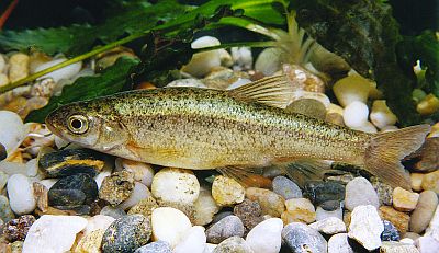
This fish is known to science since 1840 - but only in 1998 explorers managed to see it in its natural environment.
The lake contains lots of this fish. Even at 70 m depth there have been observed large swarms of Delminichthys adspersus - with up to 200 fishes in such groups. In evening they rise up to the surface of water and are seen from above as "mysterious" black spots.
In Dinaric Alps there are found several more related species of Delminichthys genera - but none outside Dinaric Alps. These fishes require extremely clean water of Dinaric karst and are highly endangered.
The legend says: If you throw the stone hard enough and if it falls into the lake you will get married! 
HR:
Na prostoru Imotske krajine najpoznatije je Crveno jezero, inace najdublje krško jezero u Europi, a medu najdubljima i u svijetu. Rijec je o jednoj od najvecih ljepota Imotske krajine, a i šire. Znanost njegov nastanak tumaci kao proces nagloga urušavanja dna ponikve, koji još traje. Jedno od vecih urušavanja dogodilo se 1942. godine, kada je Imotsku krajinu pogodio jak potres. Jezero se smjestilo kilometar zapadno od Imotskog. Ime mu potjece od crvenkaste boje stijena koje ga okružuju. Prema najnovijim istraživanjima, dno jezera je šest metara ispod razine Jadranskog mora, a vodostaj mu varira, jer ga vodom opskrbljuje rijeka koja protjece pri samom dnu jezera. Jedan od izvora jezera je u Jažvi u Glavini, na kojem se lovi poznata riba gaovica. Inace, u jezeru se nalazi više od 16 milijuna kubika pitke vode. Nikada nije presušilo.
Zastrašujuca provalija
Zastrašujuce djeluje kada se s ruba jezera pogleda u provaliju. Tišina nad jezerom još više pojacava taj dojam. Koljena pocnu klecati, a ima onih koji od straha ne mogu pogledati u crveno grotlo. Ako pokušate baciti kamen u jezero, budite oprezni, koristite dobru tehniku i aerodinamican kamen. Neuspješno bacen kamen pada na rubove jezera, uzrokujuci urušavanje drugog kamenja, što izaziva buku, ali i strah drugih posjetitelja jezera.
Engleski arheolog Wilkinson, koji je svojedobno istraživao jezero, zabilježio je cinjenicu da se domace stanovništvo spušta u grotlo jezera kako bi posjeklo oskudno drvece za ogrijev. Bio je sav u cudu dok ih je gledao kako s drvecem na ledima izlaze iz jezera, dok se iza njih culo kotrljanje kamenja. Drugi putopisci žalili su što Dante nije vidio jezero, jer bi ga zasigurno opisao u nekom pjevanju Pakla u "Božanstvenoj komediji".
Za Crveno jezero vežu se i neki tragicni dogadaji. Tijekom Drugog svjetskog rata, njemacki vojnici u jezero su srušili dva americka bombardera B-24. Poginulo je petnaest clanova posade, a pet ih se spasilo iskocivši padobranom. Bilo je i lijepih dogadaja, poput onog iz 1958. godine, kada je jezero preplivala Tatjana Kosanovic. Njezin je pothvat i danas vrijedan poštovanja, jer se u jezero teško spustiti i uz najbolju alpinisticku opremu.
Potvrdit ce to i sudionici avanturisticke utrke "Imo adventure", koju organiziraju clanovi ronilackog i planinarskog kluba Imotski. Utrka spada u najteže utrke takve vrste u Hrvatskoj.
Legenda o Gavanu
Na mjestu današnjeg Crvenog jezera, prema legendi, živio je bogati Gavan sa svojom ženom i djecom. Bili su poznati po raskalašenim proslavama, ali i po svojoj oholosti i preziru prema siromasima.
Njihova oholost razljutila je Boga, te im je poslao andela prerušena u prosjaka. No, Gavan i njegovi ni prema njemu nisu imali milosti, pa im se dogodi prokletstvo i njihovi dvori nestadoše u velikoj provaliji koja se ispuni vodom.
Bezdan
Crveno jezero do sada je bilo predmet istraživanja nekoliko znanstvenih ekspedicija. Jedna od vecih bila je medunarodna speleoronilacka ekspedicija Crveno jezero 98., koja je prvi put znanstveno istražila ovaj jedinstveni spomenik prirode.
Source: internet
Your tasks for to log this earthcache:
1. Not mandatory - just optional: Make a photo of yourself (or your GPS) with Red Lake sinkhole and visible water surface in background on the referecne coordinates (N43 27.216 E17 11.821) (see the example photos) and add this photo to your log. I don't want you to climb down the cliffs, just make picture from up - next to the path.
2. What is original (Croatian) name of the Red Lake ?
3. What exactly causes reddish-brown color of the lake cliffs - from the chemical point of view ?
4. How deep is located the bottom of Red Lake according near information table (N43 27.208 E17 11.840) (how many meters above or under sea level) ?
5. Add your aswers for tasks No.2-4 to email and send it to: mates333@gmx.com with subject "Red Lake" or via message directly on geocaching.com .
The logs which will not comply with the requirements will be deleted (correct answers).
This is my first Earthcache.
