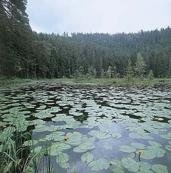

Der Huzenbacher See ist einer der schönsten Karseen des Nordschwarzwaldes. Der See liegt in 747 m Höhe in einer nach Nordosten offenen Karnische. Er ist etwa 2,7 ha groß und bis zu 7,5 m tief. Die steile bewaldete Karwand steigt 160 m hoch an.
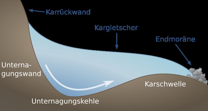
Die Kare im Nordschwarzwald verdanken ihre Entstehung der Vergletscherung während der letzten Eiszeit, der Würmeiszeit, die erst vor etwa 10000 Jahren endete. Die ergiebigen Schneefälle zu Beginn der Eiszeit sammelten sich auf nach Norden und Osten ausgerichteten Hangmulden zu gewaltigen Schneemassen an, die sich unter ihrem Eigengewicht zu Eis zusammenpressten.
Im Laufe der Zeit entwickelte sich ein Gletscher, der mit der Zeit zu groß für die Karmulde wurde und allmählich talwärts glitt. Bei diesem Gleiten hobelte der Gletscher seine ursprüngliche Mulde, das Kar, sehr tief aus. Zusätzlich glättete er auch die Talhänge an denen entlang er sich talwärts schob. Durch die Erosionskräfte des gleitenden Eises wurde die Rückwand des Kares extrem steil.
 Nach Abschmelzen des Gletschers blieben in den Karen hinter einer Felsenbarriere, dem „Karriegel“, Seen zurück, die meist im Laufe der Zeit verlandet sind.
Da der See früher aufgestaut wurde löste sich der ehemalige Schwingrasen vom Ufer ab und schwimmt als Insel auf dem See. Zwischen Ufer und Schwingrasen findet man Teichrosenbestände.
Quelle:
„Meyers Naturführer Baden-Württemberg“
Meyers Lexikonverlag Mannheim/Wien/Zürich von Dr. Adolf Hanle 1989 S.190
Um diesen Cache loggen zu dürfen, musst du folgende Aufgaben erledigen:
Am See findest du eine Hütte mit Informationstafeln. Diese werden dir helfen die Fragen zu beantworten.
Bitte sende eine Mail an Antwort1Antwort2Antwort3Antwort4@gmail.com. Ihr bekommt in den nächsten Minuten eine Antwort mit der Logfreigabe. Falls nicht sendet bitte eine Mail an mein Profil. Macht ein Bild von euch und / oder eurem GPS mit dem See und fügt dieses Bild eurem Log zu.
"Sende mir die Antworten auf die Fragen per Messenger oder Email. Danach kannst Du sofort loggen. Ich melde mich, wenn etwas nicht stimmt. Es wäre schön, wenn ihr ein Bild von euch und / oder eurem GPS mit dem See macht und dieses Bild eurem Log zufügen würdet."
(Wegen eines Trolls im Mai 2019 geändert. Der Autoresponder ist immer noch aktiv.)
Fragen:
1. Fachbegriff für einen See der als Wasserspeicher für die Flößerei verwendet wird? (Der Begriff in Klammer)
2. „Über den geheimnisvoll in der Bergnische liegenden See ranken sich viele Sagen über Nixen und ...“ Das folgende Wort.
3. Fläche des Karbodens in Hektar (ha) (Einstellige Zahl).
4. Nach welchem Berg sind die beiden hier liegenden Kare noch benannt (7 Buchstaben)


The Lake Huzenbach is one of the most beautiful cirques lakes in the northern Black Forest. The lake is situated at the altitude of 747m and opens in direction north east. The surface has 2.7ha and is 7.5m deep. The almost vertical forested headwall is very steep and 160m high.
The cirques lakes in the northern Black Forest originate from the glaciation during the Ice Age which ended only 10000 years ago. The heavy snow falls at the beginning of the Ice Age gathered at the northern and eastern slope hollows. These gigantic amounts of snow squeezed together under their own weight and turned into ice.
In the course of time, a glacier expanded that became too big for the corrie hallows and descended the valley. Sliding down, the glacier planed its initial corrie deeply. In addition it smoothed the slopes of the valley where it moved downhill. Due to the eroding forces of the sliding ice the headwall of the corrie became extremely steep.
 After the melting of the glaciers, lakes remained in the corries behind a rock barrier. Most of these lakes dried up in the course of time.
Because the lake was dammed in order to raft for wood, the quaking bog broke from water's edge and is swimming as an island in the middle of the lake. Between strand and quaking bog cow lily put forth.
Source:
„Meyers Naturführer Baden-Württemberg“
Meyrs Lexikonverlag Mannheim/Wien/Zürich from Dr. Adolf Hanle 1989 p.190
In order to log this cache you must do the following:
At the lake you will find a refuge with information plates. If you read those, you should be able to answer the questions without any problems.
Please send a mail to Answer1Answer2Answer3Answer4@gmail.com. You immediately get an answer with the log release. If not send a mail to my profile. Please take a picture of you and / or your GPS with the lake as background and add this picture to your log entry.
"Send me the answers to the questions via messenger or email. After that you can log immediately. I'll contact you if something is wrong. It would be nice if you took a picture of you and / or your GPS with the lake and added that image to your log."
(Changed due to a troll in May 2019. The autoresponder is still active.)
Questions:
1. Technical Term for a lake who is used as a reservoir to use to raft for wood? (the solution stands in brackets)
2. „Über den geheimnisvoll in der Bergnische liegenden See ranken sich viele Sagen über Nixen und ...“ The next word.
3. Size of cirque ground (Karboden) in hectare (ha) (one digit).
4. Which mountain gives the two cirques in that region the name. (7 characters)