SERPENTINITE STEPPE OF MOHELNO
| [ENG] National Nature Reserve Serpentinite steppe of Mohelno |
| Cadastral community |
Mohelno |
| Area |
50,34 ha |
| Altitude above sea level |
260 - 384 m |
| Proclaimed |
1933 |
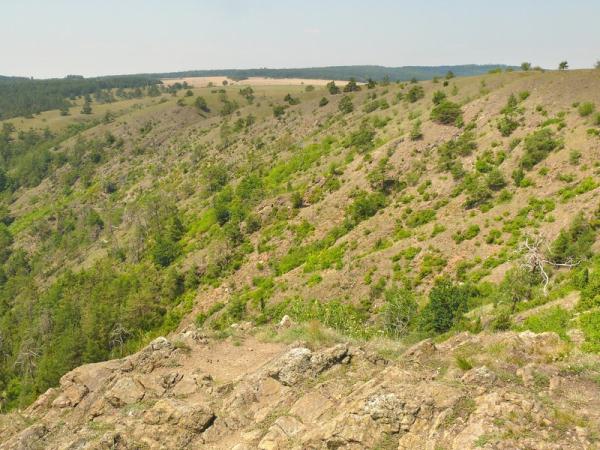
Mohelenská hadcová step (Serpentinite steppe of Mohelno) covers an extensive complex of xerothermal communities of serpentinite rocky steppe, thermophilous grasslands and serpentinite pinewoods and is a unique territory from a number of viewpoints. The territory has been protected since 1933. The physical and chemical properties of the serpentinite rock, together with the ruggedness of the relief and the variations in microclimatic conditions have led to the unusually varied vegetation, flora and fauna communities which are found here. The specific character of the serpentinite basement has influenced the formation of some of the morphological peculiarities of the flora and fauna in the reserve, especially the nanism (dwarfed growths).
The NNR is a rocky and predominantly south-facing amphitheatre on the left-side valley slopes above the Jihlava river and the neighbouring peneplaned plateau which lies 150 metres south of the village of Mohelno in the south-east of the kraj Vysocina – Bohemian-Moravian Highlands Region. The buffer zone includes the rocky headland on the right bank of the Jihlava river – the so-called Certuv ocas – Devil’s Tail and the surrounding slopes around a sunken meander. The reserve covers an area of 50.34 ha at elevations of 260 – 384 metres above sea level, with the buffer zone covering a further 8.89 ha. The NNR lies in the parish of Mohelno and the buffer zone is in the parish of Dukovany.
The basement is formed predominantly of serpentinite, which was formed by regional metamorphism of basic rocks. The serpentinite consists of minerals of the serpentine group, especially antigorite and chrysotile with a high magnesium and iron content. Coarse-grained gabbro also accompanies the serpentinite. The serpentinite body near Mohelno is enclosed in granulites of the Námešt – Krumlov massif. Parts of the granulites are recrystallized and such minerals are close in character to gneisses. The etchplain of the Znojemská pahorkatina hilly land is broken up by the deeply incised meanders of the Jihlava river valley with frost-riven cliffs on the serpentinite and talus aprons. The Certuv ocas (Devil’s Tail) rocky headland lies on the right bank of the river. In places the serpentinite is covered with Pleistocene loesses and loess loams which also include calcareous nodules (“cicváry”). The majority of the surface of the serpentinite body lacks a covering of weathering products. Boulder fields, boulder streams and serpentinite rock formations are found on the valley slopes. On the plateau above the valley the serpentinite is weathered with a thin soil cover. The granulite breaks down into sand-dominated elluvium, on which eutric cambisol has formed. On the lower parts of the slopes this passes into accumulated forms of cambisol of higher thickness and lower sand content. In localities where loesses cover the serpentinite, luvisols also occur. High concentrations of cobalt, chrome and nickel have been measured in the soil, reflecting the presence of these metals in the serpentinite.
Further information about flora and fauna together with a protection of this area you can find here.
Source: The Agency for Nature Conservation and Landscape Protection of the Czech Republic (ANCLP CR)
More information about the serpentinite is available e.g. here.
Log conditions:
1. Add your photo or a photo of your GPS device at the locality to your log. The best place is the look-out.
2. Send me answers to these questions by e-mail by my profile.(optional according to the new rules)
a) What does an apperance of the stone evoke and give it the name?
b) Which cancerogenic mineral does form dikes in the serpentinite?
c) What is the altitude of the look-out measured by your GPS device?
You can log without waiting for confirmation but if the conditions aren't fulfiled, you'll be contacted or your log will be deleted.
Recommendation:
If you want to see the interesting sites of the steppe, I can warmly recommend you to pass a local sight-seeing nature trail, which could be connected with hunting of the nice multicache GC115FQ Mohelno - step.
MOHELENSKÁ HADCOVÁ STEP
| [CZE] Národní přírodní rezervace Mohelenská hadcová step |
| Katastrální území |
Mohelno |
| Výměra |
50,34 ha |
| Nadmořská výška |
260 - 384 m |
| Vyhlášeno |
1933 |
Rozsáhlý soubor xerotermních společenstev hadcové skalní stepi, teplomilných trávníku a hadcových borů představuje unikátní území z řady hledisek. Byl vyhlášen chráněným územím již v roce 1933. Fyzikální a chemické vlastnosti hadců spolu s členitostí reliéfu a proměnlivostí mikroklimatických podmínek v území jsou příčinami neobyčejné pestrosti vegetace, květeny i zvířeny. Specifika hadcového podloží ovlivnila i vznik některých morfologických zvláštností flóry i fauny, zejména nanismu.
Jde o skalnatý, prevážne k jihu obrácený amfiteátr na levém údolním svahu Jihlavy a přilehlou plošinu holoroviny, 150 m jižně od obce Mohelno. Na pravém břehu je do ochranného pásma NPR zahrnut skalnatý ostroh zakleslého meandru Jihlavy, tzv. Čertův ocas, a přilehlý svah. Území leží v nadmořské výšce 260–384 m a má výměru 50,34 ha, ochranné pásmo zaujímá dalších 8,89 ha. Území leží v katastrálním území Mohelno, ochranné pásmo se nachází v k. ú. Dukovany.
Geologický podklad je tvořen převážne hadcem (serpentinitem), jenž vzniká regionální metamorfózou bazických hornin. Serpentinit tvoří minerály skupiny serpentinu, zvláště antigorit a chryzotil s vysokým obsahem hořčíku a železa. Hadce jsou doprovázeny i hrubozrnnými gabry. Mohelenské hadcové těleso je uloženo v granulitech námešťsko-krumlovského masivu. Část granulitu je rekrystalována a takové horniny odpovídají již rulám. Do holoroviny Znojemské pahorkatiny jsou hluboko zaklesnuté meandry údolí reky Jihlavy s mrazovými sruby na hadcích a suťovými plášti. Na pravém údolním svahu je skalnatý ostroh Čertův ocas. Na hadcích jsou místy uloženy i pleistocenní spraše a sprašové hlíny, v nichž se vyskytují vápnité konkrece, tzv. cicváry. Většina povrchu hadcového tělesa je bez zvětralinového pláště. Na svahu údolí jsou kamenná moře a proudy, serpentinit vytváří skaliska, ale na plošině nad údolím je serpentinit zvětralý, s mělkými půdami. Granulit se rozpadá na písčité eluvium, na kterém vznikla kambizem eutrická. Posledně jmenovaný typ přechází ve spodních částech svahu v hlubší a těžší akumulované formy kambizemě. Pomístně se na sprašových překryvech hadce vyskytuje hnědozem typická, v malé míře v lese také luvizem typická. V půdách byly naměřeny vysoké obsahy kobaltu, chromu a niklu, které jsou dány přítomností těchto težkých kovů v hadcích.
Další informace o floře a fauně i o ochraně tohoto území najdete zde.
Zdroj: Agentura ochrany přírody a krajiny ČR (AOPK ČR)
Více informací o hadci se dozvíte např. zde.
Podmínky pro zalogování:
1. Připojte k logu svoji fotku nebo alespoň fotku svého GPS přístroje, pořízenou na lokalitě, nejlépe na vyhlídce.(podle nových pravidel nepovinná podmínka)
2. Pošlete mi odpovědi na uvedené otázky pres e-mail u mého profilu.
a) Co připomíná vzhled kamene a co mu též dalo jeho jméno?
b) Který rakovinotvorný minerál tvoří v kameni žilky?
c) Jaká je nadmořská výška vyhlídky změřená GPSkou?
Logovat můžete bez čekání na potvrzení správnosti odpovědí. Pokud nebudou splněny podmínky pro zalogování, budu Vás kontaktovat, popřípadě bude log smazán.
Doporučení:
Chcete-li se blíže seznámit se zajímavostmi Mohelenské hadcové stepi, vřele doporučuji absolvovat okružní naučnou stezku, a případně to spojit s odlovem pěkné multicache GC115FQ Mohelno - step. A když už půjdete kolem, nezapomeňte na zábavnou mysterku GC6PE1H Mohelensky mlyn.