Hasta See Shasta EarthCache
Please note Use of geocaching.com services is subject to the terms and conditions
in our disclaimer.
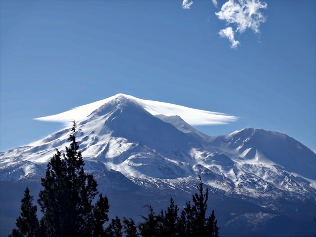
Mt. Shasta rises abruptly, 10,000 feet over the surrounding landscape, capable of being seen from over 100 miles away. At 14,162 feet it is the second highest peak of the Cascades, the largest in sheer volume, and is a majestic sight from almost any viewpoint. The coordinates will take you to a designated viewing area along the highway. You will not find a container here, but instead you are invited to learn more about this mountain and its geology.

"Lonely as God, and white as a winter moon, Mount Shasta starts up sudden and solitary from the heart of great black forests of Northern California"
- Joaquin Miller |
The mountain has inspired many. For the Shasta people, it was the center of creation, a dwelling where the Creator lived, smoke rising from the center hole of the lodge, or a place where Coyote obtained fire for the people. The Wintu still practice healing rituals at the springs that flow from the mountain. More recent arrivals to the area have said that masters from the lost continent of Lemuria roam through jeweled corridors deep inside the mountain or otherwise identified it as a "power center." Many people have a similar experience to that of John Muir:
"When I first caught sight of Shasta, I was fifty miles away and afoot, alone and weary. Yet all my blood turned to wine and I have not been weary since. Go where you may, there stands before you the colossal cone of Shasta, clad in ice and snow, the one grand unmistakable landmark - the pole star of the landscape."
The Geologic History
The mountain's geological tale is as fascinating as any of the legends surrounding it. It extends back to when smaller plates of the earth's crust slid (or were subducted) beneath the North American plate. This process carried sea water into the earth's mantle. As the plates heated, this water was released and caused the surrounding rocks to partially melt. The molten rock, called magma, rose toward the surface. Some cooled to form bodies of crystalline rock deep within the surface, but other magma erupted to form volcanoes.
Subduction has continued along the Northwest coast for millions of years, but the Cascade peaks we see today record only a short span of this activity. The ancestor of Shasta erupted 300,000 years ago, creating the largest known landslide on earth. From there, the Shasta began to rise again. Shasta is not a single peak but a multiple formation that can be identified from this site..
The oldest cone is Sargents Ridge, which was deeply dissected by glaciers, and only remnants can be seen today. Misery Hill is the second cone that grew atop the glaciated northwestern flank and makes up a large part of the present mountain. Shastina forms a separate peak, west of the Summit. If Shastina stood alone it would rank as the third highest mountain in the Cascades. Hotlum Cone forms the present summit. Most of its growth occurred after the glaciers retreated 6000 years ago. Its last eruption occurred in 1786, seen from the coast by the explorer La Perouse.
The Mountain's Future
In light of the Mount Shasta volcanic system's nearly 600,000 year eruptive history and the continuing geothermal and seismic activity on and around the mountain today, future eruptions are considered very likely. Shasta is monitored for physical changes -- increased seismic activity, uplift, and the emissions of heat and volatiles -- that might be associated with the rise of magma into the shallow crust. Under favorable circumstances such changes may give warning in advance of an eruption. Some geologists have reconstructed its eruptive history to calculate the intervals for various types of events and found that the mountain erupts roughly once every 250-300 years. The mountain may be "sleeping," but it remains quite active.
Logging Requirements
Please email me through my profile rather than use the message center.
Use the information from the signs at this viewpoint and your own observations to learn more about the mountain. If you are pulling a trailer you have to park in a safe spot by the road. Email the answers to the following questions to the developer of this earthcache (be sure to identify the name of the cache).
- Name at least two other volcanic mountains or rock formations that you can see from this spot. What do these formations tell you about the geological history of the area?
- Name two glaciers can be seen from this spot. Based on your knowledge, the observations you make, and the signage do you believe the glaciers have been growing or retreating?
- Based upon your observations, estimate the distance between Shastina and the main summit.
- Include a photo from the earthcache location with Shasta in view. You do not have to be in the photo - a personal item, your gpsr, or the informational signs (that do not show any answers) are all fine under current (June 2019) guidelines.
Please submit your answers before logging this as a "find." Logs that have not fulfilled the logging requirements will be deleted.
Additional Information
The Geology of Mount Shasta: The definitive guide to Shasta's geology by Dr. William Hirt, professor of Geology at the College of the Siskiyous. Related pages include information on the mountain's lore, environment, history, and literature.
Introduction to the Geology of the Mount Shasta Region: Dr. Hirt's geological overview.
The Volcanic Legacy Scenic Byway: Learn more about the volcanic features, history, and travel through this region.
Additional Hints
(No hints available.)
Treasures
You'll collect a digital Treasure from one of these collections when you find and log this geocache:

Loading Treasures