|
 
The underground river systems of the Yucatan flow beneath
the entire peninsula. During the ice ages when the ocean levels
were much lower than they are today,what was once a giant
coral reef became exposed to the atmosphere and eventually became
the Yucatan Peninsula. Massive cave systems were formed by gradual
dissolving of the highly porous coral limestone.These caves are called
"solution caves" because they were formed by the slightly acidic
rainfall dissolving the alkaline limestone.Inside the caves the geological
formations such as stalactites and stalagmites are a spectacular sight to see.
Many of the caverns eventually collapsed and the sea levels rose
partially or completely flooding the cave systems.The water table
of the entire peninsulais filled with consists of seawater at sea level
and freshwater 'floating' on top at varying depth depending
on the distance from the sea.
Stages in the formation of cenote
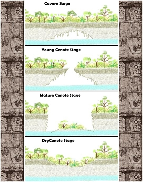
( Copyright "Cenote Stage Pictures" Luca Ridarelli )
Learn more about cenotes http://www.ridarelli.net/cenotes/english/index.htm
Cenotes are complexes of sinkholes and caves in the Karst geological
landscape of the Yucatán. Some cenotes contain spectacular cave formations,
while others are important archaeological sites,and several were considered
sacred by the Mayans. A few are open to the public for swimming and
diving. Of the estimated 30,000 cenotes, many of them unexplored, many are
considered to be Mayan cultural and archaeological sites.Ancient fossilized
remains of Camels, giant Jaguars and Mammoths are among the interesting
archaeological finds in recent years.
One of the most impressive is the Cenote Sagrado, which is 60 metres (200 ft)
in diameter, and sheer cliffs that drop to the water table some 27 metres
(89 ft) below. The Cenote Sagrado was a place of pilgrimage
for ancient Maya people who, according to ethno historic sources,
would conduct sacrifices during times of drought.
Archaeological investigations support this as thousands of objects have
been removed from the bottom of the cenote, including material such
as gold, jade,obsidian, shell, wood, cloth, as well as skeletons
of children and men.
( source: wikipedia.org, wikitravel.org, ridarelli.net )
|
|
Log Requirements  
You may log this cache and email the answers at the same time.
Logs containing any answers to questions will be deleted.
1. Describe the walls of the cenote!
Make a small drawing and paste it to the log! (optional)
2. What color is the water of the cenote?
3. Describe a plant species at the edge!
4. This cenote was once a place of sacrifice. Describe your feelings regarding this fact.
5. Send me an e-mail with the answers to 1,2,3 and 4.
6. Upload two photos from you or your gps-device
*at the pyramid - castillo / * near the cenote (optional)
|