TB Hotel du Chemin de Croix
Multicache qui va vous faire traverser Fresse à la recherche d'indices nécessaires aux calculs des coordonnées de la cache finale. Cette quête peut être faite à pied ou en tout autre moyen de locomotion sauf l'avion. Le terrain d'aviation est en construction! La distance entre Le Magny et Le Vatey, aller et retour est d'environ 5 Km.
Multicache will take you through Fresse in search of clues necessary for calculations of coordinates of the final cache. This quest can be done on foot or by any other means of locomotion except aircraft. The airfield is under construction. The round trip Magny and Vatey is about 5 km.
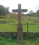 |
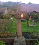
Notre Chemin de Croix commence au Magny, en N47° 45.802, E006° 38.166 (Waypoint: QUEST1)
Our Way of the Cross begins at Le Magny in N47° 45.802, E006° 38.166 (Waypoint: QUEST1)
Question:
A B C D = Date gravée sur la croix / A B C D = date engraved on the cross
|
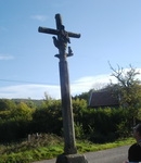 |
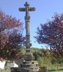
Continuer jusqu'à Grande Croix, en N47° 45.697, E006° 38.234 (Waypoint: QUEST2)
Continue on one's way to Grande Croix, N47° 45.697, E006° 38.234 (Waypoint: QUEST2)
Question:
E = Nombre de personnages se trouvant sur la Croix / E = Number of figures located on the Cross
|
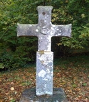 |
Allez au Jovis, en N47° 45.836, E006° 38.615 (Waypoint: QUEST3)
Go to Le Jovis in N47° 45.836, E006° 38.615 (Waypoint: QUEST3)
Question:
F = Nombre de cœur(s) visible(s) sur la croix / F = Number of heart (s) visible (s) on the cross
|
 |
Dirigez vous au Volvet, en N47° 45.495, E006° 39.158 (Waypoint: QUEST4)
Head over to Le Volvet in N47° 45.495, E006° 39.158 (Waypoint: QUEST4)
Question:
G H I J = Date que vous lirez sur la croix de l'oratoire; Ste Barbe vous aidera! Date you read on the cross of the oratoryl. St. Barbara will help!
|
 |
Avancer jusqu'au Centre du village, en N47° 45.492, E006° 39.306 (Waypoint: QUEST5)
Advance to the center of the village, N47° 45,492, E006° 39,306 (Waypoint: QUEST5)
Question:
K L M N = Date de la Mission d'Indulgence / K L M N = Date of Indulgence's Mission
|
 |
Enfin allez jusqu'au Vatey, en N47° 45.417, E006° 39.553 (Waypoint: QUEST6)
Finally go to Le Vatey in N47° 45.417, E006° 39.553 (Waypoint: QUEST6)
Question:
O P Q R = Date sculptée sur la colonne / O P Q R = Date carved on the columnn
S T U V = Date que vous pouvez lire sur la croix / S T U V = Date you can read on the cross |
La cache finale qui abrite un TB Hotel, se trouve en:
Nord (N)(V)° (E)(P-O).(C-A)(D)(R-Q) Est (J)(J)(H-G)° (C)(L-K).(T-S)(F)(I-H)
The final cache, which houses a TB Hotel is located in:
North (N)(V)° (E)(P-O).(C-A)(D)(R-Q) East (J)(J)(H-G)° (C)(L-K).(T-S)(F)(I-H)
-
Rendez vous au parking de la cache (Waypoint: PARKFINAL: N47° 45,244, E006° 37.702):
-
soit en marchant par le Sentier des Deux Vallées au départ du parking de l'Auberge La Bormillière (Waypoint: INN: N47° 45.755 E006° 38.414) suivre les ronds jaunes. Distance aller et retour: 5 km. Ce sentier de moyenne montagne est mal entretenu mais très agréable. Prévoir de bonnes chaussures de marche.
-
soit en suivant la route, à pied ou en voiture, au départ du Terrain de Camping (Waypoint: CAMP: N47° 45.325, E006° 39.156) Distance aller retour environ 6,5 km. Vous pourrez profiter d'un beau point de vue sur la vallée de l'Ognon (Waypoint: VIEWPOINT N47° 45,441 E006° 37,463). En hiver, se renseigner sur les conditions d'enneigement et de circulation.
-
To go to the parking of the cache (Waypoint: PARKFINAL: N47 ° 45.244, E006 ° 37.702):
-
Or take the signposdted foot path called "Sentier des Deux Vallées", marked yellow dots and starting from the parking of the Auberge La Bormillière (Waypoint: INN: N47° 45.755, E006° 38.414). Distance round trip: 5 km by mountain path, poorly maintained, but very enjoyable. Bring your hiking shoes.
-
Either follow the road, by foot or by car from the camp (Waypoint: CAMP: N47° 45.325, E006° 39.156) You can enjoy a beautiful view over the valley of L'Ognon (Waypoint: VIEWPOINT: N47° 45.441, E006° 37.463). Round trip distance about 6.5 km. In winter, learn to snow conditions and traffic.
 |
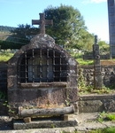
Ne manquez pas d'allez brûler un cierge à la dernière station de votre chemin de croix; L'Ancienne Abbaye du Mont de Vannes (Waypoint: ABBEY: N47° 45.211, E006° 37.658) elle est située à 200 m du parking de la finale et est ouverte en journée. Vous devrez vous y rendre, à pied, car elle n'est accessible que par la cour de la ferme.
Do not forget to go burn a candle at the last station of the cross; The Abbey of Mont de Vannes (Waypoint: ABBEY: N47° 45.211, E006° 37.658). It' is located 200 m from the parking and it is open during the day. You will get there on foot, because it is accessible only from the farm.
|
Pour plus d'information sur cette Abbaye datant de 1681, consulter le site:
For more inforamation about this Abbey datted 1681 visite:
Milles Etangs