Die Brücken des
Weißenbach - 4
The Weißenbach Bridges -
4
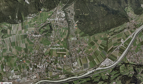
Der Weißenbach entspringt oberhalb der
Herrenhäuser im Halltal und fließt durch das Halltal.
Er bildet die Gemeindegrenze zwischen Hall i.T., Mils und
Absam.
Er ist ca. 8,3km lang - die Quelle liegt auf 1.580m.
Der Bach überwindet einen Höhenunterschied von ca. 1000m bei einem
Gefälle von 8-9%.
Er mündet in der Nähe der Westbahnstrecke in den
Inn.
Das ist der 4. Cache einer 7-teiligen Serie am
Unterlauf des Weißenbach.
Die Serie führt von der Mündung des Weißenbach in den Inn bis zum
Eingang des Halltales.
Um die gesamte Serie zu machen benötigst du 3 h reine Gehzeit (2 h
aufwärts; 1 h abwärts).
Dieser Fußsteg führt über den Weißenbach von Mils nach Absam.
Er ist bei Wanderern sehr beliebt - man kann hier auch sehr oft
spielende Kinder treffen, die den Weißenbach aufstauen.
Beachte die Hinweise in den Deckeln der Caches - sie führen dich zu
einem Bonuscache, den du am Rückweg suchen kannst!
The Weißenbach rises above the
Herrenhäuser in the Halltal and flows trough the Halltal.
It marks the borderline between Hall i.T. and the villages of Mils
and Absam.
It is about 8.3km (5.2mi) long - the spring is located at
1.580m.
The brook overcomes an altitude
difference of 1.000m and has a gradient of
8-9%.
It merges near
the Austrian Railways route with the Inn River.
This is the 4th cache of a series
of 7 Caches at the lower reaches of the
Weißenbach.
The series leads from the merging
of the Weißenbach with the Inn river up to the entry of the
Halltal.
It takes about 3 hrs walking time for the whole series (2 hrs up; 1
hr down).
This pedestrian bridge leads you across the Weißenbach from Mils to
Absam.
It is very famous for walkers - you can find here playing kids who
are daming the Weißenbach very often.
Don't forget to collect the hints
in the lids of the caches - they will lead you to a bonuscache,
which you can search on your way back!
© Land
Tirol
Stage 1:
Wo der Cache liegt, kannst du wie folgt bei der Stage 1
ermitteln.
Wenn du bei den Koordinaten stehst und nach Süden schaust, wirst du
ein gelbes Schild entdecken.
A=Einstellige Quersumme der 1.Reihe
B=Zahl in der 2. Reihe von oben
C=Zahl in der 4. Reihe *10
D=Gasnotruf
To find the cache you have to
calculate the coordinates at the Stage 1
If you are standing at the coordinates and look to the south you
will discover a yellow sign
A=Single-digit cros sum of the numbers of topmost row
B=Number of the 2nd row from the top
C=Number of the 4th row from the top multiplied by 10
D=Gas emergeny number (Gasnotruf)


Final:
N 47 17.(B*3-C+2) E 11 31.(B+C+D-A+6)


Hinweise/Hints:
Wenn du auf der Tour "Die Brücken des Weißenbach" bist,
solltest du von der Stage 1 kommend,
über WP3 und WP4 leicht hierher finden.
Zum nächsten Cache der Serie solltest du die Brücke auf die
Westseite überqueren,
dem Wanderweg folgen und bei WP5 rechts abbiegen und zu den
Koordinaten des nächsten Caches gehen.
Ganz in der Nähe des Final dieses Caches befindet sich übrigens
Samorial GC2TBKW von Widderin.
If you are on the tour "Die
Brücken des Weißenbach"
is should be easy to come to this point follwing WP3 and WP4
To continue to the next cache of the series you should cross the
bridge to the west bank and turn right at WP5.
Nearby the final of this cache you can search for Samorial GC2TBKW from Widderin.
Cache #5
von: