Der Barnim im Tegeler Fließtal
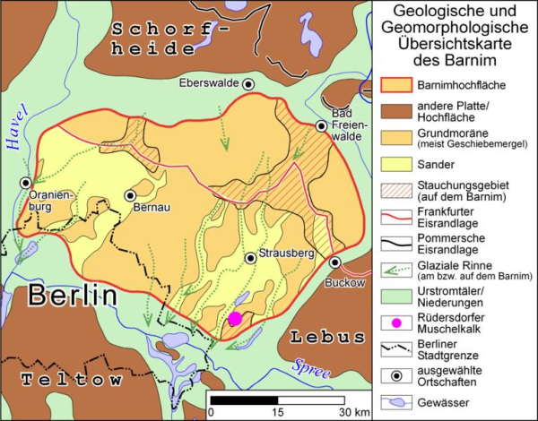
Der Barnim ist eine eiszeitlich gebildete Hochfläche und gleichzeitig eine historische Landschaft im mittleren und nordöstlichen Brandenburg und im Nordosten Berlins. Als Teil der in der Weichseleiszeit gebildeten Zone der Brandenburgischen Platten und Urstromtalungen, besteht der Barnim aus Grundmoränen, einem Endmoränenzug und Sanderflächen zwischen dem Berliner Urstromtal im Süden und dem Eberswalder Urstromtal im Norden. Anteil am Barnim haben heute die Landkreise Oberhavel, Barnim, Märkisch-Oderland und Oder-Spree. Auf Berliner Stadtgebiet liegen die Stadtbezirke Reinickendorf, Pankow, Lichtenberg und Marzahn-Hellersdorf zu großen Teilen auf dem Barnim.
Die Grenze des Naturraumes Barnim kann recht genau gefasst werden, da sie deutlich ausgeprägt ist. Die Südgrenze bildet das Berliner Urstromtal, welches von der Spree durchflossen wird. Weiter südlich schließt sich die Hochfläche des Teltow an. Die Grenze zwischen dem Barnim und dem weiter westlich gelegenen Ländchen Glien wird von einer von Nord nach Süd verlaufenden Urstromtalung eingenommen. Der Höhenrücken auf diesen Hang wurde unter dem Eis zusammengedrückt. Er ist Ausläufer der Grundmoräne des Barnim.
Quelle: Wikipedia
Um den Earthcache loggen zu dürfen, müssen 3 Fragen beantwortet werden, die ihr mir bitte über das Nachrichtencenter schickt. --- Ihr könnt sofort loggen, sollte etwas nicht stimmen melde ich mich bei euch !---
Die Fragen ergeben sich wenn ihr euch an den Koordinaten befindet. Dort befindet sich eine Informationstafel. Lest den Text und schaut euch um.
1. Welche Objekte befinden sich außer der Tafel noch hier?
(direkt am Schild und links daneben)
2. Wie lautet der Sponsor der Infotafel?
3. Welches Jahr wird gesucht?
Am Ende der Eiszeit vor ….. Jahren?
_______________________________________________________
 Version
Der Barnim im Tegeler Fließtal
The Barnim was created in the glacial period and is a High level plain and a historical scenery in middle and northeast Brandenburg and in the north-east of Berlin. As a part of the zone Brandenburger Platten and Urstromtalungen created in the last glacial period, the Barnim developed of ground moraines, a terminal moraine train and Sanderplains surfaces between the Berlin Urstromtal in the south and the Eberswalder Urstromtal in the north. Today the administrative districts Oberhavel, Barnim, Märkisch-Oderland and Oder-Spree have interest in the Barnim. In Berlin lie the parts of Barnim in the city districts Reinickendorf, Pankow, Lichtenberg and Marzahn-Hellersdorf.
The border of the Barnim is exactly. The south border forms the Berlin Urstromtal. The Spree-River is floating here. Further to the south the high level plain of the Teltow joins. The border between the Barnim and the Glien in the west is formed by the Urstromtalung running from north to the south. This Place on this slope was crushed under the ice. He is a stolon of the ground moraine of the Barnim.
Source: wikipedia
To be allowed to log the Earthcache, 3 questions must be answered. Please send the answers via Message Center.
There is a Signboard here. Read the text and look around.
1. Which objects are near the Signboard?
(directly near the signboard and to the left of it)
2. What is the Name of the sponsor of the Signboard?
3. Which year is searched?
Am Ende der Eiszeit vor ..... Jahren?