Ground Water and U S. Geological Service Drought Indicator Wells
Ground water is simply water that is below the surface of the ground upon which we stand. The old adage, “out of sight, out of mind,” is sometimes the thought given to ground water. The vision of underground water for some people is the idea of under ground streams flowing like one reads about in some fiction and even non-fiction works. There are occasional flows of water that meet this scenario as seen in caverns. In normal circumstances, groundwater flows through the sand and rocks of the ground beneath our feet. How far down below depends on the aquifers in the region the individual is standing.
The material that holds the water is an aquifer. By observing as one pours a soft drink over crushed ice in a cup, one sees how water flows through sand and rock. The fluid runs down through the crushed ice simulating the rock and sand to the bottom of the cup. The bottom of the cup simulates the bottom of the confining unit demonstrating a model of an aquifer. Now if one places a straw in the glass, this represents a well placed in the aquifer. A note on aquifers is that in this part of North Carolina there are many aquifers. One prominent deep aquifer in the area is the Middendorf Aquifer. Many of the local municipalities in this area pump water from this aquifer for their city/town water source. It is a continuation of aquifers from the western part of the state. For the purpose of this Earthcache, I am not going to deal with the deeper aquifers. This Earthcache will to pertain to a more shallow aquifer that holds ground water. The aquifer in this presentation will be the Black Creek Aquifer.
Ground water always moves away from an area of high pressure toward an area of low pressure. The term we use for this is down gradient. Gradients exist because as mentioned above water enters the water tables at higher elevations and eventually flows towards the ocean. The natural gradients are frequently altered by withdrawing water from the aquifer through wells, natural springs, and seeps.
One sees a source of ground water each time it rains. Often, the thought is the rain just feeds vegetation in an area. While it is true that the rain gives life sustaining moisture to the plants, trees, grasses, and flowers, not all of the rain is taken up by vegetation. A certain portion is filtering down through the soil, as in the example of the soda in a cup of crushed ice, to be captured in the aquifer below. It is this water that a large portion of the people in this region rely on for there water supply. This slow seepage down of water helps recharge the aquifer that flows in an easterly direction toward the sea. One of the problems with the use of shallow ground water wells in a small area is it leads to a drop in the water table. Usually, the water table replenishment is from the normal periods of rain. When there is insufficient rainfall coupled with unbridled usage, the aquifer suffers resulting in wells drying up or yields diminishing. With prudent water use and distribution of wells in an area, there is a reduction in the draw down effect. The drawing below, from the NC Division of Water management, illustrates the cycle of ground water.
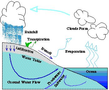
In the coastal plains area of North Carolina, it is standard practice to remove water from aquifers confined in clay strata. The layers of clay above and below the flow of water create pressure and prevent upward flow. Wells placed into the water containing strata to access the water allow the water to come toward the surface to a level equal to the pressure of the water. The term for this is potentiometric surface.

Often the water level is above that of the surrounding land. This well is a flowing well. It gets its pressure from being lower that the higher elevations of the aquifer recharge area.

A benefit of the confining strata is the water is able to move longer distances due the effect of powerful pumps of municipal, county, agricultural and industrial systems. The downside to this is the interference the competing system have trying to draw water from the same areas.
An example of this problem is seen in the Kinston, NC area. "In the area surrounding Kinston, North Carolina flowing wells were common in the 1920s. Between then and now, water levels in wells have fallen more than 150 feet in response to the aggregate pumping from public water systems, agriculture, and industry. Concerns grow with poor management of water resources for the effects on the aquifer. In addition, water level draw downs put pressure on communities with increasing populations to find alternate sources of water. That means use of surface water or a shallower aquifer which is more easily recharged."
With draw downs of the fresh water aquifers occurring, there is the worry that salt water will filter into the voids and areas of decreased water pressure in the aquifers. With more pumping of freshwater in the zone where the freshwater-saltwater interface occurs, the risk of salination of the water is a real possibility. Treating water in this area would become more costly which eventually results in higher cost to the consumer.
Approximately 27% of North Carolinians receive their water from ground water sources. If one considers only the coastal plains area, the number using ground water sources increases to 90%. It goes without saying the importance of each one of us understanding the need to preserve not only water resources but to preserve all natural resources.
The North Carolina Division of Water Resources and the USGS operate a network of monitoring wells throughout North Carolina. At present there are 563 groundwater monitoring wells at 186 locations. These wells serve as monitoring points for the water resources we all use. This well is located on the Sandhills Game Land Management Area near Marston, NC. While one may think this is an odd place for the placement of such a well, it really is an ideal place for this organization to monitor the aquifer that runs through the area. This well is identified as USGS 345812079313401 SC-080 (NC-194) NR MARSTON, NC (BLACK CREEK). It is managed in cooperation with the NC Department of Environment and Natural Resources’ Raleigh office. Data is collected related to a variety of parameters to give information on the health of the aquifer. Chart below gives one basic data on this well.
Latitude 34°58'14"
Longitude 79°31'42"
Scotland County, North Carolina
Hydrologic Unit 03040204
Well depth: 39 feet
Hole depth: 39 feet
Land surface altitude: 433 feet above sea level NGVD29.
Well completed in "Northern Atlantic Coastal Plain aquifer system" (S100NATLCP) national aquifer.
Well completed in "Black Creek Aquifer, Upper" (211BAKCU) local aquifer “
For a map of current well locations, click here. NC Division of Water Resources monitors these wells to assess natural and man-made impacts to the ground water resources of North Carolina. Currently these groups work within the North Carolina district of the United States Geological Survey through the USGS-NCDENR Cooperative Agreement to monitor 17 wells at 17 locations. NC Division of Water Resources has active monitoring wells in 57 of the one hundred NC counties. The USGS cooperative agreement adds wells in 7 additional counties. Monitoring Well Network News is available to keep up with DWR network changes. ”
In the Coastal Plain, NC Division of Water Resources typically installs monitoring wells in areas with actual or potential ground water management issues, most relating to ground water overuse. This arrangement provides NC Division of Water Resources data necessary to assess how climatic conditions impact ground water supplies. In addition, The hope is that collecting data by river basin will help us understand how these climatic conditions affects the base flow to streams and rivers, which in turn can dramatically affect the surface water supplies of dozens of North Carolina communities. View the Drought Indicator Wells, a page designed to show the changing availability of ground water as it with influence by rainfall in a 48 well subset of the network.
The construction of the well is important to prevent contamination of the aquifer. Below is a diagram of the construction of the well at this location.

So now we have wells in place to monitor the water, how do gather the data in order to have some useful information? Of the 25 wells in the system, statewide, 24 have satellite data uplinks that periodically send the data to a receiving station in Raleigh. The 25th station has monitoring equipment read on site by computer uplink connection. What is the data received telling us about the health of the aquifer? The following map and legend demonstrates the level of drought in the areas of the monitoring wells in North Carolina.

Requirements for claiming this EarthCache:
To log this EarthCache, send me an e-mail (Not part of your log entry!) with the following:
A. Make the first line of your e-mail: "Black Creek Ground Water & Drought Indicator Well"
B. Tell me how many are in your party.
C. Send me answers to the following questions and include the photo with your log entry.
D. There are two sites very close together that need to be visited to claim this cache:
First co-ords: N34 58.491 W079 31.558
Second co-ords N34 58.233 W079 31.700
First site.
1) What is the soil type in the immediate vicinity of the well?
2) This well is for ground water monitoring, what is the impact of many household close together wells on the same aquifer, such as the Black Creek, and on wells further down the aquifer’s flow?
3) Why is ground water monitoring so important, other than for the obvious that we need to know the amount of water available?
4) What is the current drought level for this area? Use this link for obtaining this data.
2. Second site.
1) What is at the second site?
2) What organization’s name is on placard?
3. Photo of area at first co-ords. While a photo of the cacher is appreciated, that way I may recognize you on the geo-trail, I am not so much interested in a photo of the cacher as I am for the site. Please no spoilers, logs with spoiler photos and information will be deleted.
A word of caution to cachers: This is a hunting area. The Sandhills Game Lands are a 3 day a week hunting area; Monday, Wednesday, Saturday & Holidays. When hunting season is open, one must use caution when entering the Game Lands. This link gives a link to the current Regulations Digest for cachers to read the pertinent rules for using the Game Land.
DISCLAIMER: Remember to use caution and safety any time you are out caching. This area of North Carolina has many critters, creatures and plants that are just not as hospitable as other denizens in this fair county. Poison ivy/oak, ticks, mosquitoes, deer flies, fire ants, briars, and snakes are common. In the words of the late Cajun Cook Justin Wilson, "I am a safety engineer by trade; I wear a belt and suspenders." I suggest wearing proper clothing for the area. This may include long pants, long sleeves, and if you ignore the hunting season warning, BLAZE ORANGE. So be safe out there!
1) NC Division of Water Resources, DENR - 1611 Mail Service Center - Raleigh, NC 27699-1611, http://www.ncwater.org/Education_and_Technical_Assistance/Ground_Water/What/
2) Contact Information: North Carolina Water Data Support Team Page Last Modified: 2010-12-12 13:07:25 EST, USGS 345812079313401 SC-080 (NC-194) NR MARSTON, NC (BLACK CREEK)
| I have earned GSA's highest level: |
 |
 Dirtbag Geocaching Society