Ceunant Mawr (which translates as the waterfall of the
great ravine) is probably one of the most impressive waterfalls in
Wales on the course of Afon Arddu (River) and plunges in two stages
into the gorge below.
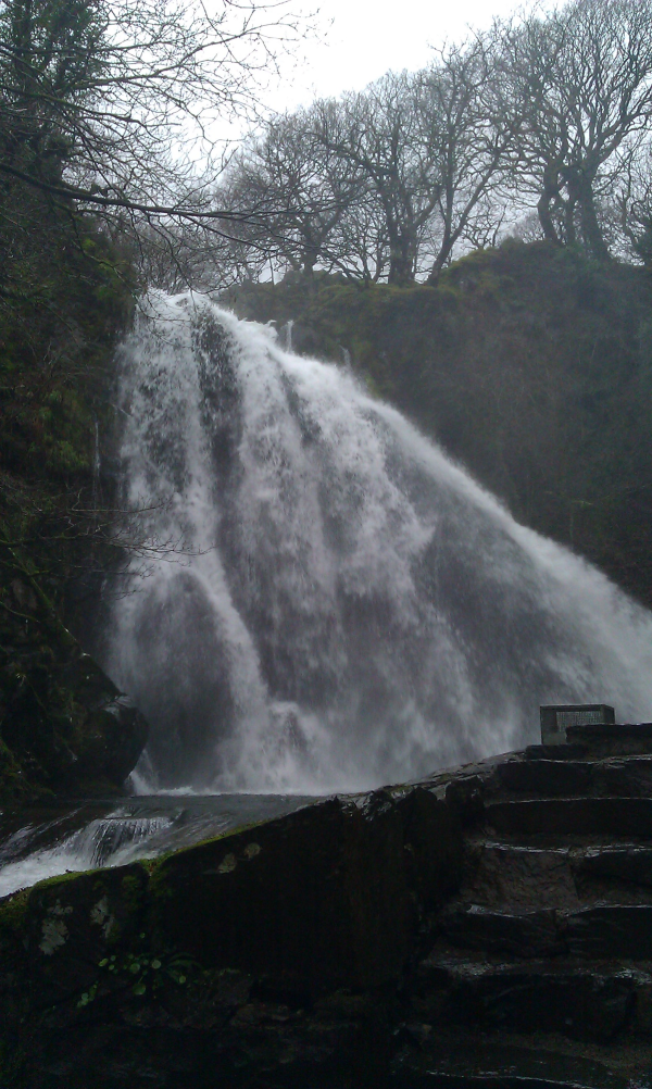
View From Below The Falls
Only 15 minutes from the High Street of Llanberis. This can be
spectacular after rain.
Start at the junction of the High Street and Church Lane (See
Waypoint), between the Parish Church and the garage.
Follow Church Lane around a curve until the Snowdon Railway viaduct
is in sight. 100m before reaching it turn right on a tarmac track
by a cattle grid.
After a few yards take a narrow unsurfaced path to the left,
skirting the house garden to reach a concrete path that runs up the
side of the Afon Hwch. Five minutes easy walking brings you to the
falls. A view from above is also possible.(This is the coordinates
given) For this follow the tarmac track uphill from the cattle
grid. Where this meets the railway a gate allows you to cross the
track (Take care!) to get a view of the falls.
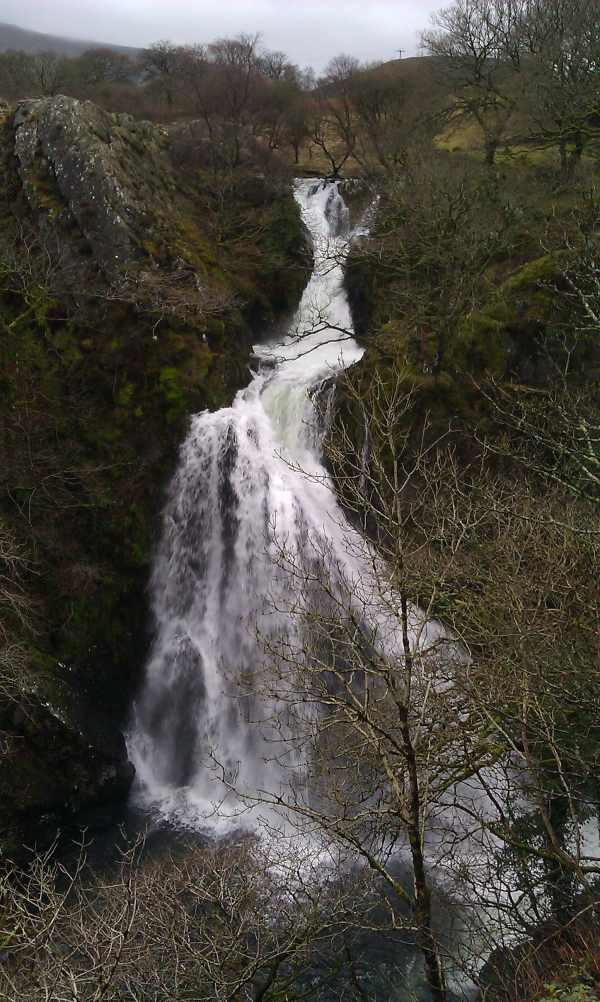
View From Above The Falls
Formation of Waterfalls
Waterfalls are most commonly formed when a river is young.
At these times the channel is often narrow and deep. When the river
courses over resistant bedrock, erosion happens slowly, while
downstream the erosion occurs more rapidly.
As the watercourse increases its velocity at the edge of the
waterfall, it plucks material from the riverbed. Whirlpools created
in the turbulence as well as sand and stones carried by the
watercourse increase the erosion capacity.
This causes the waterfall to carve deeper into the bed and to
recede upstream. Often over time, the waterfall will recede back to
form a canyon or gorge downstream as it recedes upstream, and it
will carve deeper into the ridge above it.
The rate of retreat for a waterfall can be as high as one and half
meters per year.
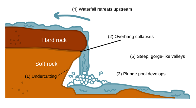
Image used under GNU Free Documentation License
Often, the rock stratum just below the more resistant shelf will
be of a softer type, meaning that undercutting due to splashback
will occur here to form a shallow cave-like formation known as a
rock shelter under and behind the waterfall. Eventually, the
outcropping, more resistant cap rock will collapse under pressure
to add blocks of rock to the base of the waterfall. These blocks of
rock are then broken down into smaller boulders by attrition as
they collide with each other, and they also erode the base of the
waterfall by abrasion, creating a deep plunge pool or gorge.
Streams become wider and shallower just above waterfalls due to
flowing over the rock shelf, and there is usually a deep area just
below the waterfall because of the kinetic energy of the water
hitting the bottom. Waterfalls normally form in a rocky area due to
erosion. After a long period of being fully formed, the water
falling off the ledge will retreat, causing a horizontal pit
parallel to the waterfall wall. Eventually, as the pit grows
deeper, the waterfall collapses to be replaced by a steeply sloping
stretch of river bed. In addition to gradual processes such as
erosion, earth movement caused by earthquakes or mudslides or
volcanoes can cause a differential in land heights which interfere
with the natural course of a water flow, and result in
waterfalls.
The Geology of Snowdonia
The complex and diverse geology of Snowdonia has done much to shape
the present landscape as land and sea have changed place more than
once. Great mountain ranges have been pushed up out of the oceans
only to be slowly eroded away, their debris carried by the rivers
and laid on the sea bed to form the substance of future
mountains.
Volcanic rocks have produced distinctive features on Snowdon,
Cadair Idris, the Glyderau, the Carneddau and Arenig. A
distinguishing feature of the rocks of Snowdonia is that some are
ancient. The fossil shell fragments on the summit of Snowdon are a
memory of life on the seabed over 500 million years ago. The oldest
physical feature of Snowdonia is probably the ‘Harlech
Dome’ created in the Cambrian era before the volcanoes
erupted. Snowdon and Cadair Idris form the northern and southern
extents of the dome respectively. What we now know as the Rhinogydd
stand at the centre, on what was the original ‘uplift’
of sedimentary rocks, composed of muds and sands, but later altered
by the volcanic activity to become the slates and grits of
today.
In recent geological terms, Ice Age activity has done much to
shape the landscape. The glaciers that were at their peak 18,000
years ago in Snowdonia scoured out great U-shaped valleys including
Llanberis and Nant Gwynant in the north and Tal-y-Llyn in the
south. The same period also formed rocky ‘cwms’ or
corries, hanging tributary valleys many of which have breath-taking
waterfalls cascading over them, whilst the characteristic pinnacled
knife edge ridges or arêtes like Crib Goch are found where two
‘cwms’ formed on either side of a mountain.
Other Geological features to look out for such as
volcanic rocks, sedimentary rocks including intrusive rhyolite,
dolerite, granite, gritstone, mudstone, slate, siltstone &
sandstone
carved rockfaces & ridges
prominent shaped peaks
rounded elevated mounds
geological layers of rocks
loose rocks & boulders
glacial mountain lakes
deep glacial valleys
mountains streams
hanging valleys
narrow gorges
volcanic rock, tuffs+ plugs
magma flow banding
ruins of mineral mines
slate quarries & slag heaps
To log this earthcache, please email via my profile with the
answers to the following questions
1:Estimate the height of the second section on the falls
You may find this
website helpful
2:What is the surrounding rock made from and how is it
created?
Also adding a photo to your log would be great but this is now
optional and not a requirement for logging the cache.